CHAPTER 10 – Venus

CHAPTER 10

Venus

The retrograde rotation of Venus is explained by
Kepler’s Second Law.

The Legend

The ancient Greeks had a legend about the god Zeus swallowing the goddess Metis, who was pregnant. She gave birth to Athena, inside Zeus, who was seized by a raging headache. Hephaestus, the son of Zeus, split open Zeus’s skull with an axe and Athena sprang out of Zeus’s skull as an adult, clothed in a suit of shining armor. Athena, associated by the Greeks with the planet Venus, became their goddess of wisdom.

Even by the usual standards of Greek mythology, this story is bizarre. One might ask why it became established at all if there wasn’t some allegorical interpretation to it. There was!

Velikovsky

A theme running through the famous book ‘Worlds in Collision’ by Immanuel Velikovsky, published in 1950, is that Venus came out of Jupiter as a comet trailing a prominent tail, and later turned into a planet. Velikovsky was an outstanding scholar who, nonetheless, included enough mistaken conclusions in his writings that many scientists failed to take him seriously. This was regrettable because he discovered ancient sources, long forgotten, which could have changed the foundations of astronomy and geology. Most scientists still fail to appreciate the significance of his accomplishments.

Velikovsky was mistaken in accepting the legend about the origin of Venus so literally. His claim that Venus came out of Jupiter as a comet which changed into a planet could not be true and astronomers knew it. He quoted numerous historical records of Venus having been observed coming from Jupiter but it apparently didn’t occur to him that Venus could have been a former moon of Jupiter, and the scientists weren’t about to help him out.

Galilean Orbits

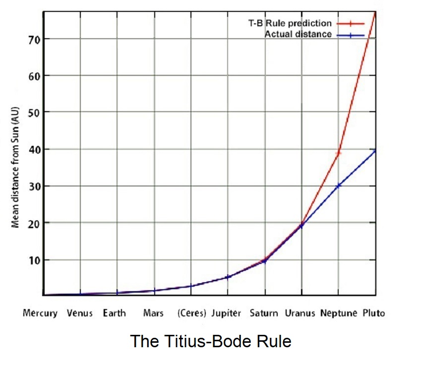
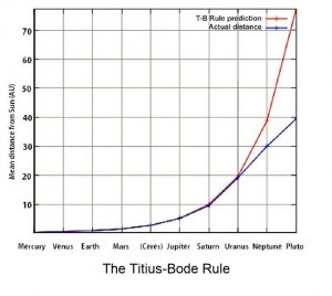
I am proposing that Venus was a moon of Jupiter until less than 4,000 years ago. It had been, in effect a fifth ‘Galilean’ moon. Jupiter’s four largest moons at present, progressing outward are Io, Europa, Ganymede, and Calisto, and the moon Ganymede is larger than the planet Mercury. They are known as the Galilean moons in honor of their discoverer, Galileo Galilei. Some scientists have claimed that the moons follow a principle called the Titius-Bode Rule and that all potential orbits from Io to Calisto are presently occupied. The rule describes how proceeding outward from the Sun, each planet is approximately twice as far from the Sun as the one before.

This ‘rule’ is something astronomers often discredit, but they still like to quote it when it suits them. The rule is absolutely real and is governed by the electromagnetic effect, but ‘fails’ ultimately with distance. Just because its influence does not extend to infinity does not make it any less a rule. The Titius-Bode Rule applies as far from the Sun as the planet Uranus before it breaks down for Neptune, although Pluto approximates the predicted position for the next planet out from Neptune.

There is another way of looking at this within the Jovian system. Astronomers have determined that the three inner Galilean moons are in orbital resonance with Jupiter. The result is that in the time it takes for Io to make four orbits around Jupiter, Europa makes two orbits and Ganymede makes one. One might suspect a presently unoccupied potential orbit since a moon between Io and Europa could have an orbital resonance of three. All four Galilean moons are tidally locked to Jupiter, presenting the same face, constantly to their planet. Venus is considerably hotter than Europa, with an interior that is cooler than that of Io, adding to the evidence that Venus once occupied an orbit between Io and Europa.

I support Velikovsky’s belief, not currently shared by most astronomers, that smaller worlds change their orbits from time to time and serve variously as planets or moons. There is not a shred of proof for astronomers’ claims that all planets and moons formed in their present orbits and have never left them. These claims directly contradict numerous ancient sources that Velikovsky identified, and are simply examples of notions that struck someone as a good idea at the time.
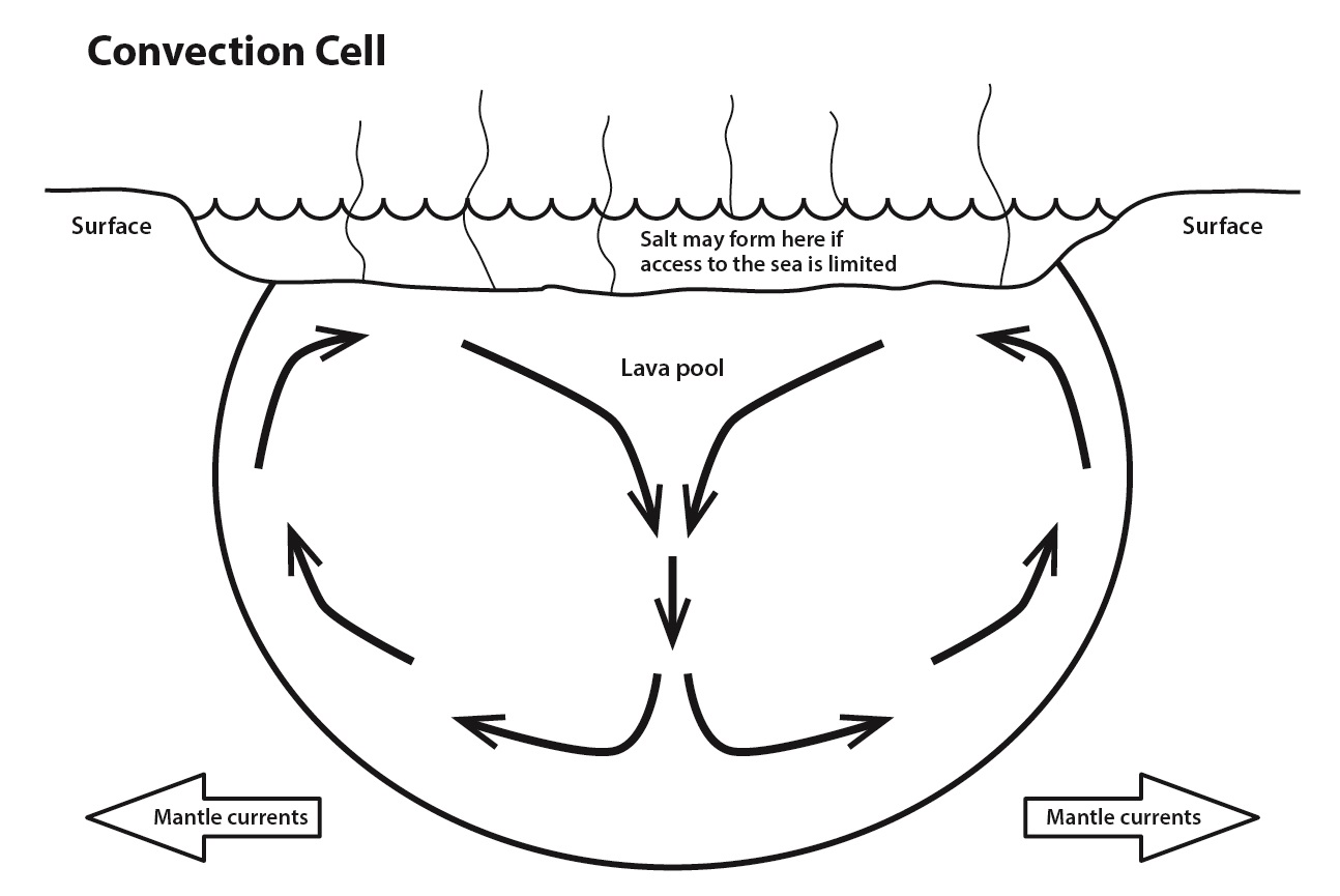
Volcanism

Io’s constant volcanism is commonly attributed to tidal heating as its interior is pulled by gravity between Jupiter and the other Galilean moons, although there is no proof of this either. Dr. Donald Scott (see below) has drawn attention to the fact volcanic centers on the surface of Io wander about, which is something that most volcanos simply don’t do. This activity is the result of electrical forces, rather than tidal attraction.

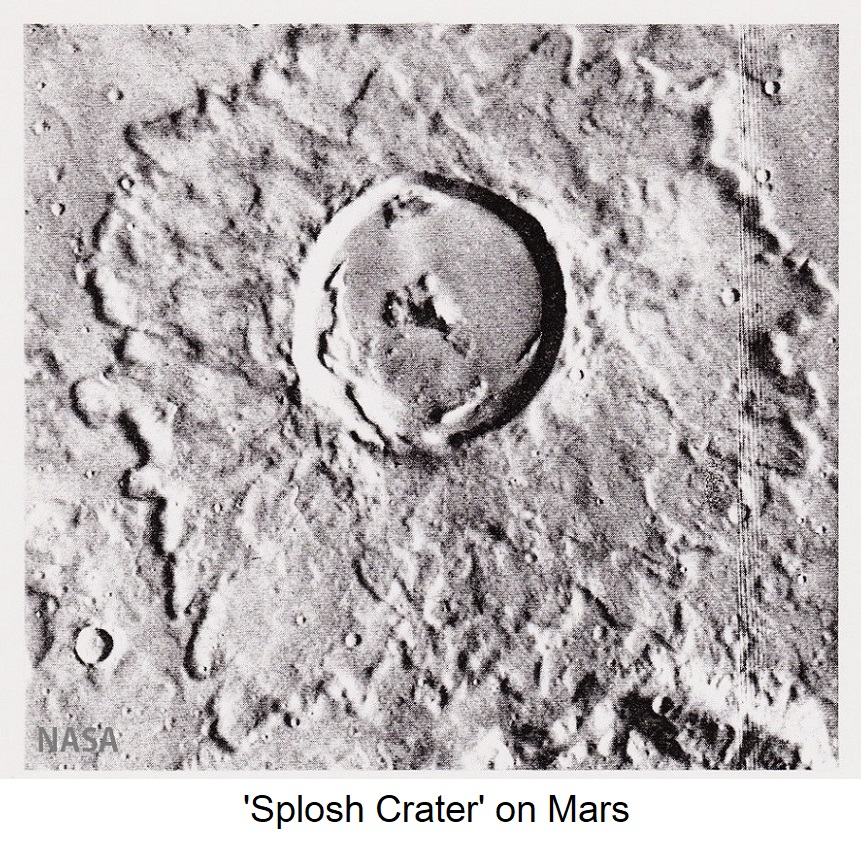
Volcanism on Venus may have been generated electrically while it was a moon of Jupiter and some volcanos appear to have moved along a circular path during their formation. Some that made less than a complete revolution formed horseshoe-shaped craters. The volcano ‘Buck’ on Venus is offered as an example of this phenomenon in ‘The Electric Sky’ (Page 138) by Dr. Donald Scott, a retired professor of electrical engineering and talented amateur astronomer. ‘The Electric Sky’, printed by Mikamar Publishing, is offered as “A Challenge to the Myths of Modern Astronomy”, and should be required reading for every astronomer.

It will not surprise my readers to learn that I do not accept every one of Dr. Scott’s conclusions. For example, I confidently attribute certain features in astronomy to distinctly different causes; such as Valles Marineris, the giant canyon on Mars (See: #12: Mars).

It could be preferable to train electrical engineers to become astronomers than to train astronomers to become electrical engineers. Be that as it may, while there is no recognized requirement for electrical engineers to become astronomers, the best thing that astronomers could do to further their understanding of the Universe would be to learn something about electrical engineering. Beliefs about our own Sun, stars, comets, our galaxy and the Universe itself too often attribute observed phenomena to gravity instead of to electromagnetism(See: #14: The Electric Sun).

The Hot Surface

Venus has the highest average surface temperature of all the planets and moons in the Solar System, including Mercury, which is only half the distance of Venus from the Sun. The surface of Venus, at almost 500o C (almost 900o F), is hotter than any atmospheric effect could achieve. Russian probes descending on parachutes indicated rising temperatures as the surface was approached, and a NASA report on the fly-by of Mariner II in 1962 confirmed high surface temperatures, also concluding: “Little greenhouse effect could occur there”.

Heat flow measurements have demonstrated that heat flows upward to the surface of Venus. (That is what Velikovsky claimed also, although he claimed Venus had a high internal temperature because it had come out of Jupiter.) The extremely high surface temperature of Earth’s sister planet has been retained since it was a Jovian moon, being heated by Jupiter’s strong electrical field.

Carl Sagan described Jupiter as a “failed star” because he believed it to be made up primarily of hydrogen and helium. He also recognized that Jupiter must take in electrical energy from its surroundings, although he failed to recognize that our Sun takes in electrical energy from its surroundings as well, as the source of its energy. Sagan didn’t have the benefit of results from the Ulysses program, but observations derived from it have been ignored by astronomers in any case.

Ulysses had the greatest potential to change astronomy of any project that ESA-NASA has carried out, but the lessons that should have been learned were ignored due to an inability of scientists to think outside of their current orthodoxy. A Ulysses-type experiment would show that electric currents enter Jupiter’s north and south poles. For those of you who are unfamiliar with the Ulysses program, the following extract is taken from Chapter #14: The Electric Sun.

The “Ulysses” Program

The Ulysses program has always been of particular interest to me. In 1994 I accepted an invitation to present a paper to the Planetary Geology group at NASA’s Jet Propulsion Laboratory in Pasadena, which is NASA’s main research and data processing facility. There, I had the opportunity of discussing the Ulysses program with scientists who were directly involved in it.

Launched from the Space Shuttle ‘Discovery’ in October 1990, Ulysses is still the only space probe to have been sent outside the plane of the ecliptic. Since there wasn’t a rocket on Earth with the capability of accomplishing this feat, a unique solution was employed. Ulysses was directed to swing around Jupiter, employing that planet’s gravity field to bring its trajectory close to a right angle to the ecliptic plane. As Ulysses sped toward the Sun, crammed with magnetometers, spectrometers, charged particle detectors, radiometers, etc. it sure looked as if science was about to be carried out.

A discovery was soon made. As Ulysses made its first approach to the south pole of the Sun NASA reported electric currents in the “trillions” of amperes flowing out of the Sun. Their point might have been made even more effective if a term like “gazillions” had been employed. (A space probe cannot measure voltage directly but it can distinguish an electric field.) One problem was that Ulysses was unable to measure the absolute strength of those currents or, apparently, to interpret the direction of current flow.

These currents constituted the most important information to come out of the entire program, but NASA’s claim that they flowed out of the Sun was made with no supporting data. It was made to agree with the prevailing belief of astronomers. Eventually, though, NASA recognized that the direction of current flow was into the Sun.

Even so, a senior member of the Solar Group at JPL assured me (by personal e-mail) that when Ulysses arrived at the Sun’s north-pole the Sun would be in the opposite phase of its 11-year cycle and then the currents would be flowing out of the Sun. (This was notable since they almost never make predictions like that.) I wrote back to tell him that there was no way this would happen (I suppose I should have been more diplomatic). I did not receive a reply.

The Atmosphere of Venus

The temperature of the Venusian atmosphere changes very little between the night and day sides, and from pole to pole, despite the slow rotation of the planet and its negligible surface winds. In fact, the only notable temperature variation occurs with altitude as ‘snow’ precipitates on the mountain tops. This is not water-snow but a different white substance, probably crystallized carbon dioxide, that precipitates out of the atmosphere. Long, narrow lava flows, frequently exhibiting an anastomosing (recombining) pattern, are an indication they formed on a hot surface. The lava remained liquid longer than it would have on a cooler surface, flowing easily and forming complex braided patterns.

Venus appears to have had an ocean, resulting in the development of a deep regolith (soil and other unattached material). If the regolith developed when Venus was a Jovian moon, superheated water and steam would have enabled deep weathering of the basalt surface. Some of the basalt probably occurs as pillow lava, which would have formed just as it does in Hawaii when molten lava plunges into the sea. Mars appears destined to attract more interest by space agencies, however, so the pillow lavas will have to wait a while before being confirmed.

The Comet Tail

A comet from the Oort Cloud was perturbed into an orbit around Jupiter and encountered Venus. Due to their disparate electrical charges, a flow of electricity surged through the comet when it encountered the moon. The comet disintegrated and its electric charge was transferred to Venus, with two immediate results.

The finer portion of the regolith was repulsed away from Venus electrically while continuing to be attracted gravitationally, enveloped by a highly reflective sheath of ice from the comet. This constituted the “comet tail” referred to by Velikovsky. Venus was propelled rapidly away from Jupiter because its electric charge was now incompatible with the charge of Jupiter. Planet and moon each carried a negative electrical charge.

Comets are powerful electrical capacitors, storing huge amounts of electrical energy. Countless comets in the Oort Cloud constitute the cathode for the entire Galaxy. Comets are commonly claimed to have been ‘leftover’ from the formation of the Galaxy, but they are not leftover from anything. Comets constitute an essential part of a beautifully functioning system that has not yet been appreciated.

The surface of Venus has been described as “clean and pristine” by NASA, for only coarse gravel and boulders now remain upon its surface. According to Velikovsky, rusty soil from Venus which entered Earth’s atmosphere accounted for the first of the ten plagues recounted in the Book of Exodus in the Old Testament and gave the Red Sea its name. Velikovsky described two close encounters between Venus and Earth, 52 years apart. It was at the first encounter that the plagues and other events recounted in Exodus occurred, and the Mayans, and others retained the memory of this interval in their tablets and monuments.

It is interesting that no magnetic field is associated with Venus, while a magnetic field has been recognized for each of the Galilean moons. Astronomers have attributed this to electric currents being induced by Jupiter’s strong field, so Venus might also have had a magnetic field when it was a moon of Jupiter. As far as is known, all the planets and moons of the inner Solar System share similar crustal rock types, the most common being basalt.

Removal from Orbit

Venus was propelled rapidly away from Jupiter since the electrical charge it had acquired from the comet was too strong for it to continue in its accustomed orbit. Since Venus moved toward the inner Solar System it was required to move ahead of Jupiter. This is explained by Kepler’s Second Law, which describes how an imaginary line from any planet to the sun sweeps out equal areas of space in equal amounts of time.

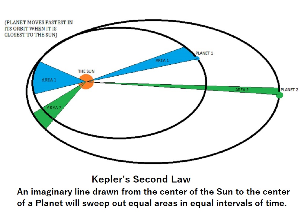
But Venus had a tidal lock on Jupiter, just as Earth’s moon has a tidal lock on Earth, always presenting its same face toward us. As Venus moved ahead of Jupiter it turned back, very slowly, continuing to face Jupiter. Distance eventually overcame this attraction, but even today Venus continues to rotate in a retrograde direction (opposite to that of the other planets), so slowly that on Venus, a day is longer than a year. One result of the retrograde rotation is that on Venus the Sun rises in the west and sets in the east. It is probable that most times a Galilean moon is displaced from its orbit around Jupiter it is propelled into the inner Solar System, due to the influence of the Sun.

The retrograde rotation of Venus is claimed to be slowing down. If this is so, Venus could eventually develop a tidal lock on the Sun (a planet behaving like a moon). It used to be thought that Mercury behaved in such a manner but Mercury is now known to have an orbital resonance of 1 1/2 rotations to each orbit it makes of the Sun. On Mercury also, the Sun rises in the west and sets in the east. The orbit of Venus is the most circular of any planet, which could not have been attained in response to gravitational capture alone; electromagnetism clearly played a role. Venus, just like Mars, is known to have a phase lock on Earth so that it presents its same face to Earth at every closest approach.

One must now recognize the electrical reality of the Solar System, a reality promoted by the late Swedish Nobel laureate Hannes Alfvén, the late Ralph E. Juergens, and continued by others, including Dr. Donald Scott, for gravity alone cannot begin to explain the wanderings of Venus and Mars as reported by Velikovsky in ‘Worlds in Collision’. He was disbelieved, although his sources are meticulously documented. One controversial source was the Old Testament, but as Velikovsky wrote in ‘Worlds in Collision’, (Page 307)….least of all do we place faith in books that demand belief, religious books, though we swear on these.”

Ancient Memories

“Or must we be in permanent collision with the planets and comets in order to believe in such catastrophes?” “Worlds in Collision” (Page 305)

Accounts of events that took place long ago have often been disregarded for no good reason. Cycles of Venus that were recorded by the Babylonians and Mayans do not agree with today’s cycles. Both civilizations, located far apart, attributed huge significance to a historical 52-year interval. Velikovsky established that this interval occurred between two close approaches of Venus to Earth, which threatened the lives of people around the world. As the new planet drew close to Earth it displayed phases, like Earth’s moon, which led to the cult of the bull in Greece, while Samoan tribes recounted that Venus grew horns.

Around the world, people retained memories of when Venus gave off smoke or had hair, or a beard. The Chaldeans compared the light of Venus to the light of the rising sun, while the Chinese astronomical text from Soochow (now Suzhou) records how Venus was visible in full daylight and rivaled the sun in brightness (‘Worlds in Collision’ Pages 164-5). Interestingly, a ‘full’ Venus is now only 1/14,000 as bright on Earth as is a full Moon. Earlier records of planetary movements, though meticulously kept, make no mention of Venus.

Velikovsky drew attention to stories about Venus that were shared by Babylonians, Greeks, Hebrews, Chinese, Polynesians, and American tribes. His investigative methods were anathema to the scientists, who imagined them to be inferior to their own. When practically identical stories are remembered by diverse groups around the world, however, there is no justification for dismissing them out of hand. People who lived only a few thousand years ago were no less intelligent or perceptive or thoughtful than us, and some recorded their observations by every means available to them.

It is wrong after historians have determined what took place in the past, for astronomers to totally disregard the product of their scholarship. They have no right to dismiss our history and replace it with their own dogma. It has been my observation that astronomers are rarely distinguished historians, and have typically taken precious little interest in human history.

I have stated that Velikovsky made mistakes, but most of them tended to involve interpretation. He recognized the influence of the electromagnetic force on the Galaxy and the movements of planets and moons away from their orbits. He knew that our geological history is mostly the result of catastrophism rather than uniformism and that the available wealth of legend and ancient history can provide a significant step toward an understanding of our past.

“It is very seldom that the same man knows much of science, and about the things that were known before science came.” Lord Dunsany (Edward Plunkett) 1878 – 1957.

Plasma Sheath

For as long as there has been life on Earth, our planet must have maintained an orbit around the Sun that is fairly close to the present one. This does not mean, however, that its orbit has never changed. Velikovsky described, from numerous sources, the length of a year changing from 360 days to 365¼ days. The circumference of Earth’s orbit increased by slightly less than 1 ½ % in 747 BC, as Venus took up its present orbit around the Sun. Mars was to take up its present orbit 60 years later.

In ‘The Electric Sky’, Dr. Donald Scott proposed that planets discharge electric currents to stabilize planetary orbits. A planet’s plasma sheath forms from electrical energy received from the Sun, which is streamed away from the Sun by the Solar Wind. The plasma sheath of Venus comes close to Earth at its closest approach, which could have required Earth to adjust its orbit slightly in 747 BC, to accommodate the insertion of Venus into its present orbit.

Earth has a plasma sheath as well, that is streamed away from the Sun by the Solar Wind. Most of the time, our Moon does not encounter this sheath due to the orientation of its orbit. Occasionally, however, our Moon encounters this sheath, and as it does it undergoes a physical shudder that can be seen from Earth, as strong electrical charges come together. I discussed this with NASA scientists when I visited JPL but they were unable to provide any explanation.

COMETS

Nucleate Comets

Life itself may originate on comets, perhaps when chains of amino acids occupying ice-crystal templates are impacted by the Solar Wind at speeds that may be high enough to result in nuclear processes. An infinite number of tiny natural factories working over infinite time may have forged reproducing life more than once, to be distributed throughout the Galaxy. When bacteria were discovered living happily in the core of a nuclear reactor, biologists were surprised that they could have evolved fast enough to tolerate such conditions. Perhaps they should not have been so surprised — these bacteria may just have felt they had come home.

I will explain in the chapter (See: #16: Cosmology 1) that microwave background radiation cannot be an echo of the big bang, as is supposed. I have proposed instead that microwave radiation results from electrical and nuclear activity on comets of the Oort Cloud. They are impacted by the solar wind as it accelerates from the Sun and from other stars.

The Oort Cloud, I propose, is not just a hollow sphere of comets surrounding our Solar System but a continuous interstellar construction throughout the Galaxy. Comets store large electrical charges which, as the Ulysses program implied, provide energy to power the Sun and the stars. Comets make up the negative terminal of the entire Galaxy. Debris and gasses from planets and moons, and crumbling asteroids, and the remains of other comets that strayed into the inner reaches of the Solar System are swept along before the Solar Wind to be added ultimately to nucleate comets in the Oort Cloud. One major population of asteroids, the carbonaceous chondrites, is interpreted here as the burned-out remains of comets that entered the Solar System in the past. They are rich in carbon, and all carbon on a previously barren Earth may have come from comets.

I propose that when planets and moons received their oceans they received the complete package. Consisting in large part of salt water, the package included bacteria, viruses (which exchange information between bacteria to initiate the process of evolution), and hydrocarbons (which provides food for bacteria). Earth received an additional gift at the catastrophe which ended the Proterozoic (late Precambrian) eon, more than half a billion years ago. Paleontologists refer to this event as the “biological big bang” due to the “explosion” of life forms that followed.

Rosetta Probe

The European Space Agency’s Rosetta Probe landed its ‘Philae Lander’ onto Comet 67-P in November 2014,  then communication with the lander was lost when its batteries died. So it was heartening news when communication was re-established eight months later. A spokesperson from NASA reminded us that…“Here is an opportunity to learn about comets, about which we know almost nothing.”  So far—so good.

The spokesperson then went on to explain how comets represent some of the oldest objects in the Universe, how they are made up of material which didn’t get included into planets, etc., etc. Does anyone detect a problem here? On the one hand, elementary research is being carried out, while on the other hand, it is essential that the results must fit into the presently accepted orthodoxy. This demonstrates one of the major problems in astronomy. No fresh thinking can be introduced which might upset the ‘Old Boys’ Network’, made up of those whose reputations are dependent upon maintaining the standing of their previously published conjectures.

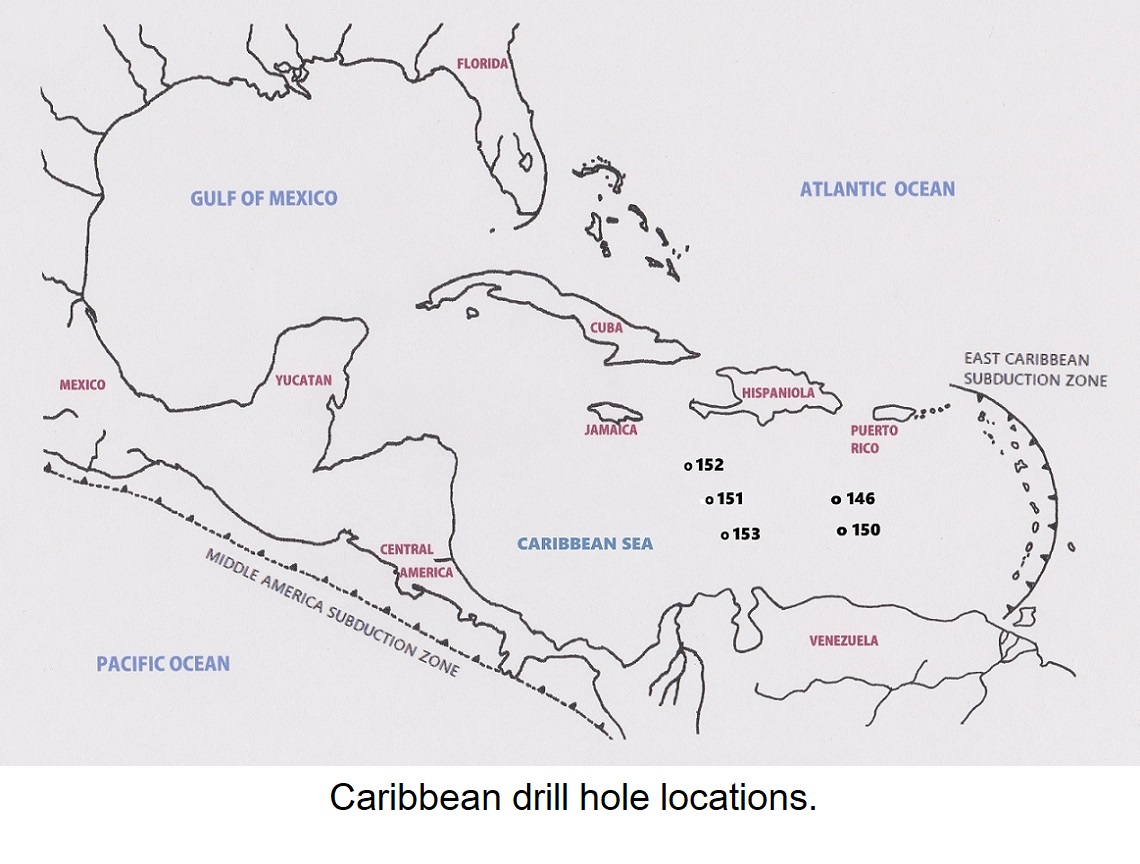
Its ‘déjà vu’ all over again. Those incredibly strong streams of electrons that Ulysses detected entering the poles of the Sun have not yet resulted in the realization that our Sun and the stars are powered by electricity. (See: #14: The Electric Sun.) Electron streams entering the poles of the Sun are no longer even mentioned on NASA’s website about Ulysses. It is preferred that anything contradicting established orthodoxy is quietly ignored, just as the USGS quietly ignored the young age of a volcanic rock formation beneath the Caribbean Sea.

Any study begun with such preconceived opinions practically guarantees flawed results. Recall what Ralph E. Juergens had to say about the Sun, long before the Ulysses program took place: “The modern astrophysical concept that ascribes the Sun’s energy to thermonuclear reactions deep in the solar interior is contradicted by nearly every observable aspect of the Sun.”

Cloud Comets

“A few Greek philosophers were aware that planets, on close contact, are greatly disturbed, and that out of their agitated atmospheres comets are born.”
(“Worlds in Collision”, Page 271).

“We do not live in a museum; we live in a factory.” M.W.

Velikovsky did not discuss these comets further, but those that formed when Venus and Mars drew close were not solid (‘nucleate’) comets from the Oort Cloud, but what I have termed ‘cloud comets’, formed in large part of highly reflective ice crystals from the nucleate comet that displaced Venus from its Jovian orbit. They came from the disintegration of the tail that had followed Venus from the time it left its orbit around Jupiter, until its encounter with Mars.

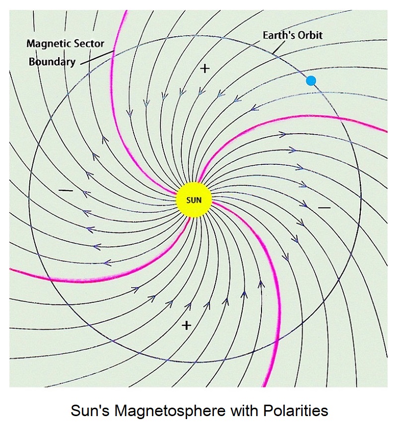
As the cloud comets passed through the quadrants of Sun’s encompassing magnetosphere, with its alternating polarities, they changed their shape as each magnetic-sector boundary was crossed. One iconic image, seen around the world and appropriated by North American natives and Hindu religious followers alike, was the swastika. Another “…took the striking form of a woman wearing a pointed hat, riding on a broom…” (“Worlds in Collision” Page 305).

For hundreds of years, these electrically charged clouds of ice crystals drifting in space were a familiar sight. Several could often be seen simultaneously, some bright enough to be visible throughout the day. Countless written reports of them still exist! Julius Caesar even retained a seer whose duty it was to predict events, based upon interpretations of these enigmatic omens in the sky which dramatically altered their shapes from time to time.

Velikovsky’s explanation of the swastika was criticized by some because they didn’t know that some ‘comets’ do not have a solid core. We don’t see comets as they occurred in Julius Caesar’s time because they have been swept away by the Solar Wind. Already, their ices, together with remnants of the regolith of Venus, may have been added to nucleate comets of the Oort Cloud.

Proofs

Critics were dismissive of the wealth of historical reports from around the world that Velikovsky had meticulously collected, substituting claims of their own instead. Nowhere is the ‘Old Boys’ Network’ more in evidence. People who lived around 4,000 years ago weren’t much different from us, and they recorded their observations by every means they could.

If uniformism is to be replaced by catastrophism, and I believe I have made a strong case for exactly that, numerous aspects of geology and astronomy will have to be reconsidered. The scientists are not going to like this much — they never do, but they’ll get over it. Ultimately science, which belongs not just to them but to all of us, stands to be enriched beyond present belief. Scientists must be challenged wherever they have ignored or denied the work of historians and archeologists and substituted a cult all their own.

CHAPTER 9 – Structural Geology

CHAPTER 9

Structural Geology

Axis change explains different latitudes recorded in rocks that formed
over the Hawaiian ‘hotspot’.

Places of Interest

One has only to glance at a physical world map depicting the ridges and canyons on the ocean floor to realize that a lot has taken place there. I hope my analysis of the history of the Caribbean and Mediterranean Seas will be helpful to geologists when it comes to interpreting other parts of the world. There are other places that I have found to be of particular interest.

The Emperor Mountain Chain

John Tuzo-Wilson (1908-1993) was an acclaimed Canadian geophysicist and geologist who made important contributions to the theory of plate tectonics. In 1963 he proposed that the Hawaiian-Emperor seamount chain resulted from the Pacific tectonic plate drifting over a ‘hotspot’ of volcanic activity. This left a trail of increasingly eroded volcanic islands and seamounts in its wake. He attributed a major kink in the chain to a change of direction in the movement of the plate, and this is the explanation that was generally accepted, until recently.

It has long been accepted, as Tuzo-Wilson proposed, that the Hawaiian Islands continue to be generated as oceanic crust moves over a hot spot, or plume, rising from deep within the Earth’s crust. Islands that sank beneath sea level as they were carried away from the hotspot continue as subsea-mountains in a fairly straight line to the northwest. The chain of islands then turns sharply to the north, with their ages continuing to increase. The last mountain at the Aleutian trench has an age of around 70 million years.

The sharp bend in the line, which happened about 43 million years ago, records the approximate age of the impact responsible. A direction of seafloor movement that had been fairly consistent for at least 27 million years, abruptly changed. Within hours, perhaps, mantle currents beneath the Pacific Basin changed from moving north to moving west.

A great circle extension of the present Hawaiian Island chain leads west directly to China, and it is inferred that the cause of the change of direction of the entire Pacific basin, from north to west could be the impact site now occupied by China. Minor dislocations in the Hawaiian subsea mountain chain reflect more recent, smaller impacts.

The direction of the mountain chain isn’t the only thing that changed. The ages provided, and the distances involved, indicate a significant increase in speed following the introduction of additional energy. Measured in seamounts per 1,000 kilometers, the volcanic activity rate increased from 13 for the Emperor Chain to 18 along the Hawaiian Chain, which suggests an increase in energy of close to 40%.

Super Computer

It has been reported that a world-leading super-computer has been added to the investigation, so you already know it will provide great results. Recent research, it is claimed, has revealed that it was really the hotspot itself that moved. ‘Wikipedia’ informs that if the hotspot had remained above a fixed mantle over the past 80 million years, the latitude of multiple samples of widely differing ages should have remained constant. The latitudes were calculated from numerous paleomagnetic measurements of rocks having determined ages over a range of 80 million years. Keep in mind as you read this, that there have been two axis changes within only the past 74,000 years and the scientists haven’t recognized them yet.

The super-computer results, it turns out, support the thesis that it was “unexplained changes” in deep mantle currents that were responsible for the 600 change of direction between the Hawaiian and Emperor Seamount ranges.

Wandering Poles

In the 1950’s geologists from Cambridge University in Great Britain, including Dr. Keith Runcorn and his students, began studying paleomagnetic data and found that rocks of different ages, from neighboring localities, indicated changed magnetic pole positions. A rock type commonly sampled was basalt, which is extruded as lava at a high temperature, and cools rapidly when it comes into contact with air or water.

Basalt contains a relatively high amount of the magnetic mineral, magnetite (Fe3O4).  Magnetite crystals which develop as the flow solidifies orient themselves parallel to force lines of Earth’s magnetic field. This enabled researchers to calculate the position of the closest magnetic pole at the time the lava crystallized. They were then able to plot what they termed “polar wandering paths” that showed how the closest magnetic pole had moved over the time interval determined.

Later, when it was realized that continents can move, scientists felt it necessary to correct the earlier work on the grounds that it was the continents that had moved, rather than the magnetic poles. Now, sadly, those determinations will have to be changed again, since the movements were the result of axis changes.

Continents move slowly while axis changes occur rapidly so that in practically every case the change can be confidently attributed to axis change. At an axis change the magnetic poles are moved rapidly, often to lower latitudes, and then take the following several thousands of years catching up with the newly situated geographic poles. Points at the geographic poles always move to lower latitudes, meaning closer to the equator.

Earth is oblate in form and it takes a while for its preferred shape to re-establish. Multiple strand lines along the west coast of Hudson Bay have resulted from Earth seeking to acquire its preferred shape since the last significant axis change, 10,500 years ago. The land here is rising rapidly, but little of this change is due to the removal of an ice cap. Land further away from the former pole is not rising noticeably even though it was covered by a similar thickness of ice. Therefore, at least most of the uplift can be confidently attributed to axis change.

South Sandwich Trench

Most island arcs are situated in the Pacific, although the Atlantic Ocean has two. The Leeward and Windward Islands form a volcanic chain above a subduction zone at the Venezuela Basin, while the South Sandwich Islands are situated 1,500 miles (2,400 km) east of the southern tip of South America. Both sites are the result of large asteroid impacts.

Just as the Puerto Rico trench at the Venezuelan impact site subducts oceanic crust that was formed at the mid-Atlantic ridge, seafloor from the mid-Atlantic ridge is also being subducted at the South Sandwich Trench. To the north and south of this site, seafloor from the mid-Atlantic ridge sweeps past, being dragged against two parallel fault systems, so that Tierra del Fuego and the Antarctic Peninsula have been retarded in their westward movement and both curve back to the east. The Scotia Sea occupies the space between these two faults, and its seafloor is practically stationary.

Island Arcs and Earth’s Energy Level

The study of Plate Tectonics has been developed about as far as it can go without a greater understanding of the energy that drives it. Island arcs continue to present a mystery to most of science even though their origin was explained by Allan O. Kelly and Frank Dachille, Ph.D., in their book ‘Target: Earth’, published in 1953. Papers on it were presented at the Western Amateur Astronomer’s Convention, in 1955, and the geological section of the American Association for the Advancement of Science, in 1957. ‘Target: Earth’ was written before much of the information available today was known, and some of its claims have been disproven. It remains, however, an example of what science could accomplish if those with open minds were to receive more encouragement to challenge dogma.

During that infamous episode in American history known as ‘The Velikovsky Affair’, one haughty professor commented smugly that he had a special bookshelf for books like ‘Worlds in Collision’, and never once had he been tempted to take down any book he had placed there. I wonder if ‘Target: Earth’ was there as well.

An island arc results from the impact of an asteroid with enough force to generate a convection cell, onto oceanic crust that is moving away from a mid-ocean ridge.

Some scientists have claimed that Earth’s internal energy level, as reflected in its subsurface temperatures, is partly left over from the time of its formation and is partly the result of radioactive decay, but these must have just struck someone as a good idea at the time because neither explanation is reasonable. If any of Earth’s thermal energy reserve had been retained from the time of its formation, plus whatever is due to radioactive decay, it could not have decreased to accommodate the growth of Pangaea and then increased again.

It is an interesting fact that much of Earth’s continental crust has been contiguous in the past and now is widely dispersed, reflecting variations in Earth’s thermal energy reserve. When the crust is widely dispersed it means that the internal energy reserve is high. When impacts are infrequent convection and mantle current activity is reduced. Oceanic crust thickens as it cools, leaving currents in the mantle to push against the roots of mountains. Larger land masses are moved, collecting islands as they travel.

Mountains have roots that extend deeper into the mantle than do lowlands, a condition geologists term ‘isostasy’. Eventually, should the energy level run down, most of Earth’s continental crust will end up contiguous and mid-ocean rift activity will cease. There is no indication, however, that this will happen anytime soon. Earth’s internal energy level is presently high and has long been on an upward trend.

The last supercontinent began to disintegrate at the end of the Permian Period, 252 million years ago, and Earth’s thermal energy reserve has increased greatly since then. Lands once contiguous are now separated, and islands – the proof of a high internal energy level – litter the seas. A question of natural interest to humans is whether the rate of major impacts will stay at its present high level, or even increase, and if so within what time frame.

Most island arcs in the Pacific Ocean occur in the far-western part, which begs the question “why?” At the end of the Permian Period (beginning of the Mesozoic era, 252 million years ago) another major event occurred. A connected system of extremely deep faults, (mid-ocean ridges) along which new oceanic crust is created, formed over the entire planet. Upwelling currents move away from these spreading centers, producing parallel, transverse faults (at a right angle to the spreading center) of great depth. These provide a conduit for the rock peridotite, the progenitor of basalt, to force its way up toward the surface of the seafloor.

The faults extend beyond the depth of convection cells, and island arcs are distorted as they are pushed aside until the entire seabed has been reworked. A clutter of distorted ridges and deeps on the floor of the western Pacific Ocean is an expression of this process. Eventually, most of those island arcs will disappear, by subduction (being returned to the mantle) or by obduction (being added to a continent). The floor of the western Pacific Ocean will then have the uniform appearance that characterizes it further east. That is until more impacts occur.

The enormous African impact may have been responsible for the Permian Period coming to a close when it has been recognized that well over 90% of all advanced species on Earth became extinct. Advanced life on Earth came close to ending then. Obvious evidence of major impacts from earlier in the Paleozoic Era was also removed at that time.

Impact Summary

For those who are attracted to the science of geology, a promising time has arrived. The oppressive yoke of uniformism that has corrupted the science since the early 1800’s is being overthrown. You will be able to assert “There was a worldwide flood.” without being accused of being a Creationist. You will be able to acknowledge that every planet and moon and asteroid, including Earth, began, and persists, as a result of catastrophism. Worlds change their orbits from time to time and sometimes interact. When Earth becomes directly or indirectly involved, its inhabitants can become greatly distressed, and a new age begins.

Know that oceanic floods ravage the continents with such force that continental ice caps terminating within a continent are no match for them, and when the flood is reduced to a gentle swell it can lay out pine needles and rootlets in a hundred delicately stacked beds. It can provide a jigging action to stream gravels to produce the paystreak on Eldorado Creek in the Yukon, one of the greatest pay-streaks of gold ever found. But when it is at its most fearsome it can entomb entire tribes of woolly mammoths, or pile up African hippopotami in Europe in such numbers that their bones have been mined for bone ash on an industrial basis.

The Philippine Plate (Especially For Geologists)

The new theory of Plate Tectonics was developed by eager and competent investigators coming from diverse geological backgrounds. It all came together splendidly at first and everything seemed to make sense. The theory, however, was developed without regard for the origin of subduction zones, or the source of their energy.

Eventually, the absence of answers to these questions became too unsettling to be ignored. Eventually, the dogma of a new orthodoxy began to develop, and the most promising new specialty in the science of geology began to drift away from reality in a parody of the plate motions it now struggled to explain. One problem was the Philippine Plate.

When the Marianas asteroid impacted in the western Pacific it affected a significant part of the Pacific basin. The greatest depth below sea level anywhere on Earth lies within an arcuate deep known as the Marianas Trench. Several volcanos of the associated island arc have erupted in recent times. This oceanic deep marks a subduction zone whose linear extensions reach toward Japan and New Guinea.

Under different circumstances, a pair of essentially parallel faults would have formed, just as they did in the Caribbean, the Mediterranean, and the Congo. Faults, however, tend to follow paths of least resistance. In this case, a north fault formed toward Japan and the less well-defined south fault formed toward New Guinea. These faults are oriented across the direction of movement of oceanic crust that they are now required to subduct. The Philippine Plate is the most completely delimited by subduction zones of any tectonic plate on Earth.

At the Puerto Rico subduction zone in the Caribbean, the island arc has begun to split in two at its northern end, due to the westward movement of the North American plate. The island of Guadeloupe, which is situated near the southern limit of the split, has almost become two islands. Similarly, subduction of the Philippine plate at its western boundary has resulted in persistent volcanic activity along its eastern boundary.

As the Philippine plate is being subducted at its western boundary, volcanic activity at the East Pacific Rise enables this process to continue. A spreading center on the Philippine plate traveled west beyond the influence of the plate’s eastern boundary subduction zone. As it traveled, volcanic activity along it diminished, and it cooled and subsided, eventually becoming an inactive submarine ridge.

As this first volcanic zone cooled, another developed above the eastern boundary subduction zone, and the process repeated. The first inactive submarine ridge in this process, having a north to south length of some 3,000 km (1,900 mi) has moved westward some 1400 km (870 mi) from the eastern boundary subduction zone. Three successive ridges have formed in this manner, while volcanic activity continued along the east limb of the convection cell resulting from the original impact. In the accompanying USGS interpretive map, the present zone of volcanic activity is marked by the volcano symbol.

In this case, connecting faults failed to form a parallel pair, but instead defined a small plate that was itself being subducted to the west. This put tension on the volcanic zone, causing it to move west. Since new crust continued to arrive, a new volcanic arc developed above the eastern subduction zone. This process will continue for as long as new crust is produced at the East Pacific Rise.

Conclusions

There are impact sites all over our planet, hiding in plain sight. Countless others remain hidden from view, ready to contribute a reactivated limb for a subduction zone when called upon to do so. These impact sites will remain in place until they are erased by the inexorable spreading of a mid-ocean ridge. This is the only process, apart from additional impact, that is capable of expunging evidence of an impact site from the crust.

The Vredefort crater in South Africa is less than 200 mi (320 km) across and is described in Wikipedia as “one of the largest ever to strike Earth” (in the past 600 million years). In my illustration identifying some of the larger sites, the Vredefort crater is barely noticeable. At this scale, Vredefort, Chicxulub, and Sudbury Basin rated one, two and three in size by Wikipedia, are all too small to even show up well.

Earth’s entire surface has been reworked by asteroid impacts. Much of the evidence has been removed by the process of ocean-floor renewal which spreads from mid-ocean ridges, but on land, some evidence has been preserved. If every impact site on Earth’s surface were visible, the result would appear just like the surface of our Moon.

CHAPTER 8 – The K-T Boundary

CHAPTER 8

The K-T Boundary

Most fossils are formed by an oceanic flood. New species evolve
and form fossils at the next major flood. This is why the
paleontological record is so discontinuous.

A Major Catastrophe

The end of the Cretaceous Period, followed by the Tertiary Period, is best known for the extinction of the dinosaurs. The “K-T Boundary” uses the letter “K” for “Kreide”, which is German for Cretaceous since “C” had already been used for Cambrian. The relatively minor Chicxulub impact site on the Yucatán Peninsula of Mexico, often quoted as being the third largest on Earth, did not bring the Cretaceous Period to a close. Much effort, however, went into dating this site at 66 million years, which was the date the scientists required.

The sedimentary record is a record of catastrophes. One oceanic flood after another has added to the record, sometimes removing a part, or all, of what was deposited before, so that nowhere is the record continuous and complete. Catastrophes brought geological periods, and also their divisions, and smaller divisions in turn, to a close, although there is no evident periodicity to them. Sediments are deposited on the continents by oceanic floods and contain fossils of life forms living at that time. New life forms then evolve and are included in sediments deposited by the next major flood. Very few fossils are made between major floods. This is why the paleontological record is so discontinuous, which has been used by Creationists to support claims about the absence of missing links between species.

Some catastrophes are of a different order of magnitude than the rest, and what is possibly the fourth most destructive of life on Earth occurred at the K-T Boundary, which is thought to have made 80% of all species on the planet extinct. A major impact was responsible, and the Himalaya mountain range follows the arcuate limb of a major impact site that may be the one that brought the Cretaceous Period to a close. This major site probably generated a triple junction, as have other major impacts, with the Ninetyeast Ridge constituting one of the two major faults. The ridge lines up well with the center of the arc and extends south for about 5,000 miles (8,000 km). Its orientation along a meridian of longitude is a temporary coincidence.

Australia and India are often represented as sharing the same tectonic plate, the Indo-Australian Plate, even though it is crossed by the Ninetyeast Ridge. Recent earthquake activity along this ridge, where it comes closest to Sumatra, suggests a pending breakup of the plate. Several published interpretations, based on geophysics, have a possible division occurring along an east-west trend rather than north-south.

The Himalayan impact influenced the movement of India which, until then, had been moving toward the huge Indonesian impact site, which may have been the one responsible for terranes traveling across the entire Pacific Ocean to accrete onto the west coast of the Americas. The impact caused India’s path to rotate by more than 55o, as the sea floor west of Ninetyeast Ridge turned abruptly toward Asia.

The ridge has been dated as 30 million years at the south end, and 80 million years at the north end, neither age corresponding with the expected age for an impact of 66 million years. Younger or older dates, however, can be due to any number of reasons, and incorrect dates have often persisted in the geological literature until a reason was recognized to investigate further. An assumed relationship between the Ridge and the Kerguelen hotspot, in the southern Indian Ocean, may have some bearing on the present acceptance of age dates.

The Deccan Traps

As India started on its course toward Asia another phenomenon commenced. A basalt flood, which has been estimated to exceed a volume of half a million cubic kilometers, occurred over western India. Uniformist scientists have claimed that these basalt flows took “hundreds of thousands of years” to accumulate, but I was unable to find evidence to support this claim.

Fossil soil horizons, called paleosols, occurring within the sequence could constitute proof of long intervals of non-deposition, but flood deposits containing fossils do not. Layers of sediment between lava flows reflect flood deposition, but not necessarily long interruptions in volcanism. That such a layer may contain dinosaur remains does not prove dinosaurs of the types represented were alive at the time, or that they ever lived in the area. The basalt flows have been dated to around 66 million years.

Magnetic reversals have also been offered as proof of extended periods of time, but all they reveal is that certain magnetic mineral crystals were orientated toward whichever magnetic pole happened to be closest to the volcanic eruption at the time. The best defined large impact sites on Earth are younger than Permian, so if a very large impact was responsible for the K-T Boundary event, some evidence of it must have been retained. The Himalayan impact is posited as the one that brought the Cretaceous Period to a close (See: #4. Atlantis).

The Tibetan Plateau

Probably every major impact site develops shatter cones, both small (down to hand-held) and large (up to entire mountains). Different rock types, however, vary in the degree to which these structures are developed. The Sierra Nevada, the Alps and the Carpathians all provide excellent examples, but what may be the most distinctive examples of large shatter cones on Earth occur on the Tibetan Plateau. Mountains which were sculpted by the shock-metamorphic effects of the huge Himalayan impact have formed these almost perfect conical shapes along the course of the Baltoro Glacier.

The Iridium Conundrum

Origins

‘The Iridium Conundrum’ could be the title for an episode of the popular American television comedy series ‘The Big Bang Theory’, but instead describes a debate among scientists about the origin of a layer of iridium-rich sediment occurring around the world at the Cretaceous-Tertiary (K-T) sedimentary contact. Geological hotspots are thought to be connected to the lower mantle, and elements that are rare in the crust are exuded from these hot spots.

One such element is iridium, which is one of the least abundant stable elements in the Earth’s crust. Because iridium has an especially high affinity for iron, it is concluded that Earth’s core, which is accepted as being largely iron, must contain iridium as well. Deep-sourced (hot spot) volcanos are known to exude iridium. Iridium is also known to be present, at higher concentrations, in a class of meteorites called carbonaceous chondrites. Iridium is one of the platinum group metals, and it is commonly found alloyed with small amounts of platinum.

In 1979 a team of scientists from the University of California at Berkeley, led by Louis and Walter Alvarez (father and son), announced the discovery of high concentrations of iridium within a narrow band of shale outcropping on an Italian mountainside. As shown by fossil evidence of rocks above and below the contact, the shale occurs at the K-T boundary. Soon after, it was discovered that K-T boundary shale is enriched in iridium around the world, sometimes by more than a hundred times the normal amount. Allan O. Kelly had sent a copy of his book ‘Impact Geology’ to Louis Alvarez at Berkeley and this may have contributed to Alvarez’s viewpoint when he attributed the extinction of the dinosaurs to the impact of an asteroid.

The high iridium values touched off a debate between scientists favoring a terrestrial origin for the iridium, and those supporting a cosmic one. Meteorites known as chondrites are rich in iridium, but most asteroids of this type orbit further from Mars, and closer to Jupiter. Most stony and metallic asteroids are found toward the inner edge of the main asteroid belt, which is closer to the orbit of Mars. The suggestion that moons of Mars have impacted Earth is explored later. (See: #10. Venus, & #12. Mars).

Both present moons of Mars are of the stony type and follow orbits that are almost perfectly circular. (Such orbits could not result from the effects of gravity alone so that electromagnetism must have influenced their capture.) Iridium is rare in Earth’s crust, implying that Mars tends not to bring carbonaceous chondrite asteroids to Earth. Rich nickel deposits associated with impact sites such as the Sudbury basin, are also uncommon, suggesting that most moons of Mars are of the stony type, as are its present moons, Deimos and Phobos.

Meteor Crater in Arizona was caused by a meteorite composed largely of iron and nickel, and which did not provide enough energy to form a convection cell. Not every asteroid is brought here by Mars, for Apollo asteroids occasionally impact Earth randomly. It is plausible, however, that most of the largest ones were brought to Earth as moons of Mars. Concentrations of iridium that can be ascribed to hotspot volcanism are probably adequate to account for anomalous amounts of iridium occurring at the K-T boundary. If this is so, iridium anomalies should occur at other contacts at the end of geological periods.

Other elements associated with iridium at the K-T contact tend to support a terrestrial origin for it. Researchers from Dartmouth College reported in ‘Science’ finding significant amounts of arsenic and antimony at the contact. A cosmic origin for the iridium may have been promoted, in part, to support the claim that the catastrophe at the K-T contact resulted from a large asteroid impact. That concept was less acceptable to scientists in 1979.

Anomalous iridium at the K-T boundary would have been due to volcanism, especially from hot spots, following the impact of a large, stony asteroid. At that time, many volcanos were erupting all over Earth. Evidence for the impact, consisting of shocked quartz grains, as well as basaltic spherules, has been found worldwide. The spherules have been termed ‘microtektites’, although they have a totally different origin from ‘tektites’. Their close association with the impact of a large asteroid in no way requires the iridium to have a cosmic origin as well.

The iridium content of carbonaceous chondrites may be a thousand times the average content of Earth’s crust. This composition has been claimed by some as “…indicative of the average concentration of iridium in the solar system.” (Scientific American, August 1980, p.86B). What it really tells us is something quite different, which is explained in #15: Cosmic Rays.

Other Major Impact Sites

It is interesting to see how the Himalayan impact site compares in diameter with some other sites that can be interpreted on Earth’s surface. In order to make these comparisons, it is necessary to employ a physical globe to avoid distortion away from the equator. An almost indispensable aid is a piece of transparent photo-overlay material. One side of this material can be drawn on in pencil, and if a number of concentric circles at even spacing are established with a compass, an arc on the globe can be fitted along one of the inscribed circles, or else between adjacent circles. The distance from the center can then be determined by the scale on the globe.


Impact SiteDiameter (miles)Diameter (km)Age in Years
Chicxulub110177 ?
Venezuelan Basin40065010,500
Hudson Bay29047074,000
Himalayan1,6002,57566,000,000
Aleutian1,6002,575?
Amazon1,6102,590145,000,000 (?)
Kurils2,1003,380?
Indonesia2,6004,200?
Africa3,9506,350252,000,000

The measurements presented above are approximate, but provide a good idea of the scale of some larger impact sites compared to the Venezuelan Basin site. (See: #3: Impact Geology). Considering the effects of the impact that occurred about 10,500 years ago, one might ponder the effects of even the next largest in the list above, which has an area 16 times as great, a convection cell volume many times as great, and an energy level comparison at least in the hundreds.

Our ancestors, human and pre-human, must have come close to being wiped out time after time as they experienced repeated bottlenecks. Far from following a straightforward evolutionary path, let alone a predetermined one, fate played its part at every turn. It is fascinating to consider if things had followed a slightly different course, how differently the world might have ended up.

The asteroid that crashed in the Venezuelan Basin (in fact, formed the basin) totally changed the local physical geography of the Caribbean region. It ripped terranes out of Central America and moved them as much as 1,500 km (more than 900 mi.) to the east. The catastrophe also moved mantle currents to the mid-Atlantic Ridge, as well as along it, for I believe the ‘legendary’ country of Atlantis was much more than that. It was real, and its people with their sophisticated culture experienced their own bottleneck, but enough survivors may have continued on as the Pharos’ people in Egypt.

If the most recent major impact could result in geographical changes on such a scale and result in the annihilation of species from North America to Australia, consider what the effect was from even the next larger impact down the presented list. Furthermore, Earth had been impacted by another only 63,000 years earlier, and, I suspect, a larger one roughly 66,000 years before that. While our busy scientists go about their task of learning all about the Universe and cultivating their ‘Theory of Everything’ perhaps they could spare some time to look into this.

Uniformitarianism, to give it its full, disheartening name, constitutes one of the greatest debacles in all of science. While we might be willing to trade catastrophism for it in a heartbeat, now that we have benefited from it, the fact remains that we are not in control of our destiny. In all probability, Mars will continue in the role it has occupied since at least the end of Precambrian time, and if Mars should take an asteroid as large as Vesta for a moon life on Earth could eventually receive a major reset, as it did at the end of the Permian Period.

Ceres, which is another world, is several times more massive than the asteroid Vesta, but may not present a similar threat to Earth. Venus didn’t physically crash into Earth, and neither would Ceres, even if it should be brought here by Mars. As for Vesta, I couldn’t begin to compare the effects of an impact by it with what ended the Permian Period on Earth. It is categorically surreal to ponder the ultimate demise of one’s own kind and to muse upon whether the next dominant species, during its time of authority, might be less destructive of the biosphere than we have been.

CHAPTER 7 – The Mediterranean

CHAPTER 7

The Mediterranean

Italy and every island in the Mediterranean Sea
came out of Africa.

Geology

There is general agreement among anthropologists that Italians came out of Africa, along with the rest of us, including Inuit of the Arctic and Aboriginals of Australia. Not everyone, however, knows that Italy came out of Africa. Accompanying maps show the original location of Italy along with plausible origins of the Mediterranean islands. Atlases commonly depict the Adriatic Sea having opened up as Italy moved away from the former Yugoslavia. If this is correct then most of Europe was attached directly to Africa, before the Aegean impact. It appears that the Aegean impact was responsible for opening up the eastern Mediterranean Sea, but Italy and the Mediterranean islands still remained part of Africa after that event. Following another major impact, the Italian terrane bumped into Europe and the Alps began to form. As the terrane moved toward Europe, the islands broke away.

The terrane which included Italy and the islands of the Mediterranean Sea does not fit nearly as well with the present shape of the Gulf of Sirte as the Greater Antilles fit the coastline of Central America (See: #3. Impact Geology). This is because the coastline along the Gulf has elevations that are close to sea level and the area has been subjected to the oceanic floods from at least two subsequent catastrophes since the departure of the terrane.

The impact that most recently changed the geography of the Mediterranean Sea is the one marked by the curve of the famous Alps, which pass through France, Switzerland, Italy, and Austria, spilling over into Germany and Slovenia. Just as in the Caribbean, large islands were torn out of a mainland by mantle currents that were constrained between two parallel faults. Magma currents, generated from the large impact site, were deflected upward as they encountered a limb of the ancient African convection cell, but this time, things would be different.

Instead of forming an island arc of active volcanos as the denser oceanic crust was subducted, lighter sialic rocks (rich in silica) rode up upon denser rocks at the impact site. They piled up by recurrent thrust faulting, older formations being deposited on top of younger ones as surging currents in the mantle carried the African terrane along to its destiny with Europe. Mountain building continued until forces equalized between the advancement of the terrane and upward growth of the mountains.

Mantle currents surging between two faults were directed toward the coast of Africa. After the Italian terrane was torn out of Africa it rotated clockwise 300 as it was moved north, finally docking against Europe along the course of the River Po. This river follows a deep fault which coincides with the western coast of the Gulf of Sirte (Gulf of Gabès), in present-day Tunisia.  A convection cell beckoned, and thrust faults piled up layer upon layer to form a mountain range.

The best-known example of an inverted rock sequence in the Alps is the famous Matterhorn, where granite-gneiss at the peak of the mountain overlies younger, folded marine sediments. Geologists have positively identified the granite-gneiss as having come from Africa, and the marine sediments as originating along the African coast. This led to the conclusion that Africa is moving toward Europe. Although Africa is moving, ever so slowly, as revealed by extremely sensitive GPS measurements, it is also anchored to the mantle by the largest convection cell on Earth. The only parts of Africa that have moved significantly since the huge African impact has been the results of later impacts.

Islands

The Aegean impact occurred long before the Alps formed. There, islands of a remarkably pure, white limestone that had accumulated slowly on the bottom of a sea, floated upon the lava pool. Heat from the lava metamorphosed the limestone into marble, providing material for the beautiful statuary of sophisticated civilizations that developed along the shores of the Aegean Sea.

In comparing the Mediterranean to the Caribbean, there are striking similarities. Prior to the Venezuelan Basin impact, the Caribbean Sea had also been devoid of islands, and just as the Greater Antilles were torn out of Central America, Italy and the islands of the Mediterranean were torn out of Africa. One island, in particular, appears to have a remarkable story to tell. Cyprus nestled in the instep of the Italian boot, remaining there until the collision between Italy and Europe took place. Cyprus then separated from Italy and was caught by mantle currents that took it on an astonishing journey, skirting the Aegean Sea and continuing to almost the very end of the eastern Mediterranean.

Another island took a different course. Crete, with a small piece of attached crust representing Rhodes, and the other Dodecanese Islands, left Africa to cross the narrowest part of the Mediterranean Sea, stopping at the edge of the Aegean impact site. Crete is the only crust removed from Africa by the impact that formed the Alps that lay outside of the two constraining faults. This may have been due to renewed mantle activity in the vicinity of the Aegean site.

Earth’s Energy Level

Around the world, islands have been torn out of continents by impacts and scattered about the seas. Islands are an indication of Earth’s internal energy level. Numerous islands at present mean that the internal energy level (temperature) of Earth is high. This is the legacy of many large asteroid impacts, and is in marked contrast to the reason for the high internal temperature of our neighboring planet, Venus (See: #10. Venus).

Scientists continue to claim that the temperature of Earth’s interior is partly leftover from the time of its formation, and partly the result of radioactive decay. The energy level could not, however, have decreased at the time of Pangaea when the continents were supposedly joined in a single landmass, and then increased again. The two major contributors to Earth’s interior energy level are asteroid impact and electromagnetic energy derived from the Sun and the Galaxy. Radioactive decay would be a minor contributor. This is an example of how Science establishes a claim, and then stubbornly holds onto it until it is replaced by something else. (See #16. Cosmology 1).

Energy Moves Terranes

A question that should be asked when considering islands and terranes that have departed a mainland is: What is the source of the energy that prompted them to move? Cuba didn’t suddenly leave Central America just because it had been there long enough, and Italy didn’t tear itself out of Africa for no good reason. I have explained the process as it applies to the Caribbean and Mediterranean, and a comparable process must apply to similar examples around the world. Some terranes were huge, such as the sub-continent of India, and some traveled great distances across oceans, as did parts of the west coast of North American which are inferred to have traveled across the Pacific from south-east Asia following the giant Indonesian impact.

Island Arcs

In the Caribbean, the South Shetlands, and throughout the Pacific, island arcs generate arcuate chains of volcanos. What they all have in common is a large impact upon oceanic crust that is moving away from a mid-ocean ridge. The impact results in a convection cell consisting of lava that is less dense than the crust that is moving toward it. (Again, liquid rock is less dense than solid rock of the same type.) Two faults are generated from the impact site, delimiting the crust that is subducted.

If the crust were not moving, the impact site would solidify and leave little evidence, but with the movement of crust away from the mid-ocean ridge, subduction causes volcanos to form and an island arc results. Another factor is the sudden jolt of the impact that releases pent-up energy in an instant, likely increasing the rate of advance from the mid-ocean ridge to establish the subduction process. The plunging lithosphere takes seawater with it, reducing the melting temperature of the rock and as steam, assists lava to work its way to the surface. Volcanism will continue along the arc as long as crust continues to move away from the mid-ocean ridge, and may increase its movement violently from time to time in response to later impacts.

This is not the same process that took place in the Mediterranean. Although two major faults were generated toward a subduction zone, other conditions were different, and they resulted in a distinctly different outcome.

The Alps

Of all published accounts of Earth’s geographic poles changing their positions, and there are many, one that caught my attention was by Charles Hapgood, who was a history professor at Keene College in New Hampshire, and who died in 1982. He promoted a concept of Earth’s geographic poles shifting as a result of ice building up in the Polar Regions. Although I do not accept this claim, the two most recent geographic pole positions that he identified were close to my own. Moreover, he claimed a third most recent pole location, which I had been unable to determine.

I had searched the globe (a model globe) for evidence of the third most recent North Geographic Pole position without success, although I recognized several impact sites that might have been responsible. There was something else I knew, and this was that a catastrophic event of some kind, probably the 3rd most recent major impact, had occurred roughly 150,000 years ago. The evidence for this comes from a sudden and large change in atmospheric dust recorded in an ice core from the Vostok hole in East Antarctica. Similar evidence from ice cores supports the two more recent axis changes as well, which took place about 10,500 and 74,000 years ago.

I lined up Hapgood’s 2nd most recent and 3rd (adjusted) North Geographic Poles, with a length of string held against a globe. Continuing along what would have been the meridian of maximum axis change, and allowing for a reasonable change in longitude as the axis change occurred, the Alps offered a plausible fit. This is a site that I had been considering as the cause of the 150,000 years BP (before present) impact, but I lacked proof. While I could not accept the precise position of Hapgood’s 3rd most recent North Pole, the coincidence had my attention.

The site Hapgood proposed for the 3rd most recent position for the North Geographic Pole was in the Yukon, close to the Gulf of Alaska. This location is unlikely, for it would have placed all of Greenland outside the Arctic Circle 150,000 years ago. The pole could, however, have been situated further north, in the Beaufort Sea, and that would work. (Today, one-quarter of Greenland (by latitude) lies outside the Arctic Circle.)

I recently encountered a video on the internet which demonstrated how a former Yukon site for the North Geographic Pole was calculated by selecting two intersecting meridians from an equator which passed through the ruins of several ancient sites such as Angkor Wat, Machu Picchu, etc. This is nonsense for the timeline involved since all of the sites were built much later than even the most recent major axis change, which occurred about 10,500 years ago, and Hapgood was definitely not influenced by this silliness. Even so, I was curious about how he arrived at his 3rd most recent location of the geographic North Pole.

If the impact site responsible for The Alps formed 150,000 years ago the geological implications are considerable, for this impact appears to have been the one responsible for tearing Italy away from Africa, along with every island in the Mediterranean Sea. Soon after that, Italy docked against Europe along the present course of the River Po, the Alps began to form, and Cyprus began the final leg of its epic journey.

In case this sounds unlikely to some, I have offered credible proof that the Greater Antilles broke away from Central America about 10,500 years ago, and that is only 7.5 % as long ago. It isn’t catastrophism that’s wrong, but catastrophism continues to be opposed by people who were taught one thing and now have difficulty in accepting something new.

Whatever catastrophe took place 150,000 years ago, I believe that the most likely cause is the impact that produced The Alps. Before I began my quest I might not have accepted claims for the age of the two most recent axis changes either. That evidence, however, is unassailable. There will be many skeptics, of course, and even deniers, at first. I hope, however, that most will allow themselves to consider the evidence.

With two major impacts resulting in axis change occurring within the past 74,000 years and, I suggest, three within the past 150,000 years, we can begin to regard our physical world in a whole new way. The ages of the two most recent impacts can be readily determined, and for the most recent, in the Caribbean, definitive samples have already been collected and have already been age dated. Regrettably, these results have been kept hidden, and I am calling upon the United States Geological Survey to arrange to have sample-age results released to the public.

Proofs

Allan O. Kelly may have been one of the first to recognize the great array of sizes of impact structures, from hand specimens to entire mountain ranges. Granite, and especially granodiorite (the two rock types differ in their composition largely by the ratio of their feldspars) often display spires and shatter cones in the mountains surrounding an impact site. Kelly believed that these huge structures formed when granitic rocks were deeply buried, and this controlled their erosional forms upon subsequent exposure at the surface. Some of the best small-scale shatter cones have been formed in fine-grained sediments such as limestone and clay. Back in 1972, Kelly submitted a paper to a scientific journal for publication, entitled ‘The Gigantic Cone Structures of the Sierra Nevada.’  Naturally, it was rejected, since he did not have a Ph.D.

A date for the movement of the Italian terrane might be determined by drilling through present sediments to reach underlying volcanic rocks in the track left by Italy as it departed Africa, and behind the islands of Sicily and Sardinia, as they departed Italy.  Deeper Mediterranean basins such as the Tyrrhenian Sea (north of Sicily), and the Ionian Basin (south-east of Sicily), may offer good opportunities for obtaining cores for age dating.

Not many scientists would have anticipated an age of 10,500 years for the Caribbean Sea, and just as few, most likely, an age of 74,000 years for the Hudson Bay Arc. How few will fail to be surprised should an age of about 150,000 years be confirmed for the impact site that led to the present site of Italy, and the formation of the Alps?

CHAPTER 13 – The Martian Flood

CHAPTER 13

The Martian Flood

If Earth is our mother then Mars is our father, without whom we would
not be here. Mars is a stern father though, and may ultimately
expunge our species from the Earth.

“This surface geology is trying to tell us a story, a surprising story, and we might not be ready to accept it.”  

David Pieri, scientist at NASA’s JPL (quoted in “Mars Beckons”, page 115).

The claim that there are fossils on Mars will continue to be denied by most until some are stumbled upon by chance. I presented a paper on this topic at NASA’s JPL in 1994 and it didn’t convince anyone there either. The technology to enable Martian rovers to recover microfossils of Protozoa such as Foraminifera and Radiolaria from the sand dunes and send their images back to Earth is already available. The only reason for not doing so is an absence of belief.

The Space Router

The last time Earth shared its ocean with Mars may have been considerably less than two million years ago. In a significant event, during one extended and especially close encounter, the two worlds moved to within a few diameters, Earth’s atmosphere distended until it reached the Martian surface, while Earth’s ocean arose in a peak. Then the sleeve of atmosphere connecting both planets constricted to a tube. Just as a tornado conserves its energy, it tightened as it rotated.

The sleeve narrowed until it was completely occupied by the peak of water at the Earth end. The atmospheric pressure in the sleeve was that of space itself so that a giant drinking straw now existed between the two planets. Water traveled along it, preceded by a vast quantity of air. Even with a perfect vacuum, water on Earth at sea level can normally rise to only about 10.3 meters, less than 34 feet, above the surface. But this involved an almost perfect vacuum in a closed system. Given the gravitational attraction at the Mars end the system may have worked more like a siphon than a drinking straw.

It would have presented an awe-inspiring sight—a slender waterspout of prodigious proportions arcing through space from one planet to the other. Sunlight flashing off its mirrored surface and through its enveloping sheath of atmosphere, rotating as it approached Mars. A silver filament kilometers across, and thousands of kilometers high smashing onto the Martian surface.

Molecules of a fluid cease to flow when its shear limit is exceeded, and upon impact, this water was as solid as the surface it encountered. Spinning onto a surface that was itself moving laterally due to the planet’s rotation, the waterspout had become a monstrous router, blasting away the crust to a depth of several kilometers. The surface of Mars offers clear evidence to indicate water fell from above, and Noctis Labyrinthus exhibits erosional features that do not occur anywhere on Earth.

The router divided and roamed about until it arrived at longitude 53 degrees. Then the system stabilized and the stream became concentrated into two principle routers, accompanied by several subsidiary routers, as the great canyon Coprates was blasted out of the Martian crust. With an eerie degree of precision appropriate to some feat of human engineering, but on an incomparable scale, excavation proceeded at a rate that could have exceeded 100 cubic kilometers of Martian crust every second.

One might suppose that rates of water erosion on Earth have exceeded those on any other planet. It is interesting then, to consider that the greatest rate of erosion by water anywhere in the Solar System could have been attained on Mars. The water was assisted in its work by sediment from the ocean floor of Earth. Sand grains from Earth became cutting tools, and later formed the fields of sand dunes left by the ensuing flood. Remember, basalt does not contain visible quartz, so what kind of sand forms the sand dunes on Mars? It looks like quartz to me (and to Carl Sagan, evidently.)

The extensive Martian sand dunes suggest that the standing wave feeding the space router passed over a continental shelf as Earth rotated beneath it. Perhaps those who ridiculed Velikovsky’s account of Earth’s encounters with Venus and Mars would care to explain how Mars suddenly acquired and then lost, an ocean. Uniformism loses again. I hope planetary geologists, or at least everyone else, will come to understand that large fields of sand dunes on Earth are deposited by water. Later, modification of the surface may then be made by the wind. This knowledge will prove useful when the question arises as to how fields of sand dunes formed elsewhere.

The canyon named Valles Marineris spans 78o of longitude, suggesting a plausible timeframe for its development. At the present rotational speed of Mars, a point on the equator requires 5 hours and 20 minutes to rotate through 78o of longitude, while at the Earth end the water source behaved as a standing wave, with Earth rotating beneath it. The transfer of ocean water may have ended when the standing wave on Earth that was feeding the waterspout encountered land. Then, after the land had been passed by, the system proved unable to re-establish itself.

Valles Marineris displays a gentle S-curve, suggesting changes to the tilt of the rotational axes of the planets during their close encounter. Furthermore, neither of the geographic poles is well centered on its respective ice cap. In fact, the South Pole is situated outside of its ice cap. This is an additional sign of a tilting of the Martian axis while Earth and Mars occupied their conjugal state.

As the space router distributed material from the canyons over millions of square kilometers of the Martian surface a flood began to ravage the planet. There wasn’t enough water to call it an ocean, but it flowed over the planet from pole to pole. In the absence of mountain ranges and in gravity that is only 38% as strong as that on Earth even when no other world is nearby, water encircled the globe without pause. It smoothed out the surface, especially in the northern hemisphere, depositing sediment until only the largest craters remained.

The polar ice caps rotated beneath the flood, and sediment-laden water cut terraced canyons completely through them to the underlying surface in concentric spirals. Views of both polar ice caps show that the direction of the eroded channels is opposite, as seen from above, due to the rotation of the planet. As water slowed coming off the ice caps, sand settled out to form dune fields similar to many on Earth, while silt remained in suspension and was carried away.

While the major canyons were being cut by the space router, others formed by more familiar processes. Beginning at the source end, the main channel is joined by several tributaries so that the overall form is similar to that of many flood channels on Earth. Some small channels have braided forms, while the smallest are often dendritic (tree-like). Along canyons and channels of all sizes, sandy beaches formed in sheltered coves, just as would occur on Earth. The flood channels lead directly to the canyon Coprates, which continues westward for thousands of kilometers.

The canyon complex terminates in an area of broken ground, at the apex of the Tharsis Dome, called Noctis Labyrinthus. This raises a matter that cannot be lightly dismissed: If water flowing from the “source area” resulted in the channels and canyons, by what means did it reach Noctis Labyrinthus, which is ten kilometers higher? Does water flow up-hill on Mars? And how much water would it take to erode a canyon two thousand kilometers long, a hundred kilometers wide and 5 or 6 kilometers deep, on a world whose gravity is only a fraction of that on Earth?

Water was able to erode the Tharsis Dome because the water fell from above and so was unaffected by topography. This is somewhat analogous to the erosion of the Grand Canyon across the Colorado Plateau. In this case, the water didn’t actually fall from above, but the oceanic flood was so deep that density currents at its base were not diverted by the higher elevation of the plateau. Scientists unaware of repeated axis changes resulting in oceanic floods have claimed that the Colorado River managed to keep pace as the plateau rose slowly over millions of years. Geologists like things that take millions of years.

Noctis Labyrinthus

The space router became unstable as its source of water on Earth was cut off, and the reduced flow divided into several smaller routers wandering aimlessly about. Crenulations (arcuate bites) taken out of the cliffs of mesas and buttes by these smaller routers at Noctis Labyrinthus produced a type of landform that has no equivalent on Earth. Sometimes, a router cutting a stream course would double back, momentarily keeping pace with the surface and boring a pothole into the stream bed. It wasn’t only water doing this work. The fluid was a slurry of water and sand, together with larger particles of rock.

Splosh Craters

Craters on Mars that are surrounded by lobed, outward-spreading mudflows frozen in place are called ‘splosh craters.’ They resulted from the impact of ejecta from the space router onto the wet ground. Their smooth crater floors do not consist of lava (as some have been described), but of fine sediment. Most splosh craters were formed within the same few hours in which Valles Marineris was formed. Crater frequency reflects history, but not necessarily age.

Craters 50 km (30 mi.) in diameter, almost 8,000 km (5,000 mi.) away from Valles Marineris, indicate that large masses of debris from the space router went sub-orbital before impacting at low and mid-latitudes. Some small craters formed after the flood had abated, suggesting that not all of the debris returned immediately to the surface. The largest of all craters on Mars are not associated with the space router but, plausibly, could have resulted from a former moon falling out of orbit to impact the Martian surface. Just as Martian moons cause axis changes to Earth, they could result in axis changes to Mars.

The Repudiation of Uniformity

It would have been impossible for a significant volume of Earth’s ocean to be removed without including some of the myriad life forms within it. Protozoa such as Foraminifera and Radiolaria (micro-fossils) would have been present in great numbers, while not all higher forms of life could possibly have been excluded. Fish are known to move toward areas of low pressure, which sometimes results in fish falling from the sky when a storm passes by. Dolphins, whales, and even primitive rafts loaded with terrified pre-human refugees, our ancestors, fleeing flooded island or coastal homes, may all have made the trip to Mars.

This is the third reason for the title ‘Martian Grandpa’

Since Earth entered into a cooler phase at the beginning of the Pleistocene Epoch, it may have taken up an orbit further from the Sun. This could have resulted from entanglement with another world. Thus, it is possible that the prolonged encounter with Mars that generated the Space Router took place as recently as the start of the Pleistocene Epoch, which may have been between 1 and 2 million years ago. The discovery of fossils on Mars that came from Earth will constitute proof that Earth has shared its ocean with our sister planet, and the very last vestiges of that decrepit old doctrine of uniformitarianism will have been put to rest forever.

Flood Effects

Water flowed over Mars from pole to pole. The flood eroded the flanks of Olympus Mons and the other shield volcanos, as well as the walls of the great canyon Coprates. After its momentum had been spent, water flowing from highlands to lowlands cut meandering channels similar to those on Earth.

A geologically young age for the Martian ice caps is indicated by the scarcity of impact craters upon their surfaces. Ice caps are vulnerable to destruction by various catastrophic influences. The vapor pressure of ice is dependent upon temperature, so that ice caps tend to be transitory when they are closer to the Sun than the Main Asteroid Belt, and without any ocean providing precipitation to sustain them.

Along with the loss of a significant part of Earth’s ocean was the loss of air, so atmospheric pressure dropped on Earth as well. Some birds could have become flightless as a result, while back in the Mesozoic, pterodactyls would have experienced no difficulty flying in the denser air. Cooler temperatures and thinner air meant that from then on, giants on Earth would live only in the sea.

In the face of evidence that Earth has shared its ocean with Mars on two occasions, the question arises as to whether those were the only times. The quantity of water involved each time was large enough that if many such transfers had taken place a requirement would have followed for Earth’s primeval ocean to have covered practically all of the land. Life on Earth would have evolved differently if there had been so much water that no substantial dry land was exposed. Therefore, instances of Earth sharing its ocean with Mars must have been few and may have taken place only twice.

The presence of the ice caps indicates that Mars received water from Earth during an encounter before the one which formed Valles Marineris. Polar-type sediments occur close to the equator, while distinctive, pitted terrain left by an earlier transfer occurs close to the present South Pole. It is not known whether the present ice caps and older pitted terrain resulted from the same event, but this could be the case. On Mars, as on Earth, ice caps form around the geographic poles, but Mars could have undergone an axis change between its encounters.

Scientists have attributed the pitted terrain to collapse from the melting of ground ice, or (wait for it!) “…to the wind”. The pits are so similar in their distinctive form to parts of Noctis Labyrinthus that they must have resulted from a similar process. As to what might have happened to all the water and air once held by Mars, there are several processes that may have been responsible.

Atmospheric Effects

The atmosphere is readily attracted away to a close-by massive body, as we have seen. Water vapor dissociates under intense ultraviolet light into hydrogen and oxygen, and oxygen combines with iron-rich minerals in surface rocks, to form oxides. Water must be especially vulnerable in the absence of an ozone layer in the upper atmosphere. Hydrogen is too light to be retained even by Earth so that Mars would have no hold on it. Since Mars has practically no magnetic field, any atmosphere would be vulnerable to being stripped away by the solar wind.

In the explanation of cloud comets, I included this quote from ‘Worlds in Collision’: “A few Greek philosophers were aware that planets, on close contact, are greatly disturbed, and that out of their agitated atmospheres comets are born.”  Those planets were Venus and Mars, and I believe the icy tail of Venus provided the material for cloud comets known from Roman times. In addition, Mars may have contributed the atmosphere that it had once received from Earth.

Some of the carbon dioxide (CO2) in the atmosphere could have resulted from the chemical dissociation of calcium carbonate (CaCO3). Extensive dune fields suggest that the space router carried sand from Earth (grains of quartz from the breakdown of granite). That sand may have come from a continental shelf, which would typically be accompanied by calcium carbonate (CaCO3). If CaCO3 dissociates under Martian conditions, calcium oxide (CaO) may constitute some of the fine dust occurring all over the planet.

The Search for Fossils

Sand dunes constitute the most obvious and easiest target to investigate for fossils. If the sand is unconsolidated, which is indicated by the finely sculpted dune surfaces, a fine-grained fraction favoring the size range of certain fossil protozoa on Earth could be readily investigated. Separations based on specific gravity within a narrow size range could be further concentrated by additional means if necessary. There is no shortage of sand dunes on Earth to practice on that were similarly deposited by salt-water, although they have been attributed to wind.

Scanning with a low power microscope would be conducted in a search for evocative patterns such as circles, or more complex shapes, and the images transmitted to Earth. The system required is well within the ability of present technology to accomplish and should be given priority over all other NASA and E.S.A. missions. Otherwise, perhaps the rapidly advancing China National Space Administration (CNSA) would like to take it on.

Sand fractions could yield sponge spicules, fish teeth, and other small fossils. Even just determining the composition of the sand grains on Mars could provide food for thought for planetary geologists. Remember, basalt cannot produce quartz grains by weathering.

A search for microfossils could also be carried out along stream beds. Cores of sediment obtained with a vibrating drill would be scanned to identify sections yielding anomalous gamma radiation. (Gamma radiation is produced by the Potassium isotope 40K, which is common in clay). Clay-rich zones containing potential biogenic material would be separated for analysis. Samples would be washed and centrifuged, and then applied to slides for scanning under a microscope. Again, evocative patterns would be selected, and their images transmitted to Earth.

Teeth and splinters of bone must exist along natural riffles on Mars, and a promising search area could be along channels within the complex known as Noctis Labyrinthus. As riffles are chanced upon, shallow material behind them could be raked onto a vibrating sieve equipped with an air or liquid sprayer and examined. A search for fossils, especially micro-fossils, must precede any consideration of development on Mars.

There are fossils on Mars, of life forms that lived on Earth.

It is inevitable that bacteria and viruses in the water accompanied more advanced life forms. Some bacteria and viruses have probably persisted around volcanic vents or other favorable locations, and their discovery would not be especially meaningful. There would, however, be interest in determining differences they may show now compared to their kin that remained on Earth.

If any more of the advanced life from Earth should have survived, tardigrades are by far the most likely. Now numbering more than 1150 recognized species on Earth, they have been found in the deep sea below 4,000 m (below 13,000 ft.) and survived all 5 major extinction events. It would not be at all surprising if some are living in carbon-rich buried sediments on Mars.

An Israeli Moon lander which crashed on our Moon in 2019, was reportedly carrying live tardigrades, which probably survived, so tardigrades could be the very first permanent space ambassadors from Earth.

King Sennacherib’s Defeat (after ‘Worlds in Collision’)

As had once been the case with Venus, traditions of a day or night of unusual duration came to be associated with Mars in the seventh and eighth centuries B.C., for some encounters were evidently close enough to cause Earth’s axis to tilt temporarily. According to Velikovsky, the final encounter between Mars and Earth took place on the night of March 23, 687 B.C. which was the first night of the Hebrew Passover. A powerful invading army led by King Sennacherib of Assyria had bedded down for the night outside the walls of Jerusalem, prior to launching an attack. That night, most of the army was wiped out by ‘a blast’ as Mars passed close overhead. (Isaiah 37:36).

Mars evidently has a lesser electrical potential than Earth, for the lightning bolt jumped from Earth to Mars, and numerous sources are in agreement that it was by “a blast”, accompanied by a terrific noise, that the Assyrian host was destroyed. “Their souls were burnt though their garments remained intact.” (‘Worlds in Collision’) On the Martian surface, close to the face that Mars displays to Earth at its closest point, there should be a ray crater from when King Sennacherib’s army was wiped out. On our Moon ray craters, the product of electrical discharges, have irregular, rounded outlines with very steep walls, significant rock glazing, and rays made of excavated material. Some of these were visited by Apollo astronauts, but all were regarded as impact sites.

Livestock in a pasture standing aligned with the direction of current flow through the ground are sometimes killed during electrical storms, even when those with a different alignment are not. This can occur when a sufficient potential difference develops between their front and hind feet, as current flows through the ground. An animal’s body provides a path of less resistance than the ground on which it is standing, and the resultant flow of electricity can result in fibrillation of the heart. Sennacherib’s soldiers lying on the ground as Mars passed close overhead would have been especially vulnerable.

“And it came to pass that night, that the angel of the lord went out, and smote in the camp of the Assyrians a hundred and fourscore and five thousand: (5,180 dead) and when they arose early in the morning, behold, they were all dead corpses.”
II Kings, 19:35

Velikovsky wrote (Worlds in Collision’) that this passage “…is described laconically in the Book of Kings…” (My emphasis). Perhaps, but the first “they” (…when they arose…) would refer to the Israelites behind the city wall, while the second “they” (…they were all dead…) would refer to the Assyrians. The threat to Jerusalem had been removed in an instant by Mars “…the perfect warrior…who brings defeat”. These words were written years later by a grandson of King Sennacherib. This was the most recent encounter between Earth and its neighbor, for Mars then retreated to the orbit that it has followed for the past 27 centuries.

Brave New World

The ‘Terraforming’ of Mars

As a brave new age of exploration is promoted by some of our most intrepid scientists they claim that humankind “must seek greater challenges”. Earth’s present problems have not yet, evidently, become sufficiently noticeable to interest them, and some of them dream of the ‘terraforming of Mars’. This fascination with Carl Sagan would entail nothing less than the transformation of that planet’s atmosphere to a ‘shirt-sleeve’ environment in order to provide a second home for humankind. After Earth has been completely desecrated we, or at least the scientists (in their dreams), could all move to Mars.

One could look far before finding a better example of foolishness to confirm my claim that much of modern astronomy constitutes a cult. Only if the planets resided in permanent orbits could the terraforming of Mars make the slightest sense. Given the incredible cost of taking even the first tentative steps towards such a program, an unmanned probe to confirm that Mars holds fossils of life forms that developed on Earth should be especially attractive. It is practically assured that the next time Mars moves from its orbit any development there will be adversely affected, and probably destroyed, including any hapless human inhabitants.

So much about our Solar System is misunderstood that it constitutes virtual proof that our species lacks the competence to enable it to spread throughout the Galaxy. If Carl Sagan had been aware that Mars does not occupy a permanent orbit he might have been less seduced by his fantasy of terraforming Mars. If those now lining up to start a permanent colony on Mars knew that in the future Mars will leave its orbit and interact violently with other worlds, including a trip to the Main Asteroid Belt, one supposes that some might be less eager to go. I have been asked if I would personally volunteer to travel to Mars. Although I would not, there are a few special people whom I would be pleased to recommend for the trip.

Epilogue

Will Mars ever make close approaches to Earth in the future? Yes. The first sign will be a comet approaching Jupiter. Then, if a Galilean moon is displaced toward the Sun, the inhabitants of Earth can expect to encounter challenging times once again. Perhaps the Galilean moon Io, or Europa, will interact with Earth, as Venus did approximately 3,500 years ago. Perhaps the planet Venus will return to once more become a moon of Jupiter, and Mars will pass close to Earth. Even our own moon could depart Earth’s company. Whenever Mars loses one of its present moons (most likely Deimos first, the outer one) to strike Earth, the present geological epoch will come to an end and there is nothing we can do about it.

This does not portend the end of humankind, but a reset in human society. My guess is that it would be comparable to the second-last catastrophe of 74,000 years ago, but this would be dependent upon many variables. Mars brings asteroids, as its moons, close to Earth orbit and Earth’s gravity attracts them down upon us. While we regard Earth as our mother, Mars is equally our father, without which we would not be here. Mars is a stern father though, and may ultimately expunge our species from the living record.

In the meantime, it is our sacred obligation to every generation that will follow, to treat our planet Earth with more love than we are demonstrating at present. Pollution of our atmosphere may be put right with relative ease. Human overpopulation and pollution of our oceans, however, provide challenges incomparable to any that humankind has ever faced. As for Earth’s climate, it will continue to change as it always has. The only difference this time is that a natural warming trend happened to coincide with an increase in atmospheric CO2 caused by industrialization, and its effects have been misunderstood.

The scientific breakthrough in astronomy probably won’t come until the presence of fossilized life forms from Earth is confirmed on Mars. As a first step, I would like to see the sand dunes investigated because they should be easy to sample. There is something else we can do, and that is to reconsider ancient records. Perhaps those smug specialists who dismissed Velikovsky’s claims because he approached science in a different way to them, would learn something. Why is a wealth of records of the Romans, Greeks, Egyptians, Chinese, Mayans, and others, accepted by our Historians, Teachers, Writers, and Philosophers, yet summarily dismissed by Astronomers, who have substituted a cult of their own?

CHAPTER 3 – Impact Geology

CHAPTER 3

Impact Geology

The 40Ar-39Ar method has been used to date bedrock from beneath the Caribbean Sea but results have been kept hidden from the public.

The Caribbean

In the mid-1960s the United States Geological Survey made an astounding announcement that should have changed the accepted geological history of the world. The Survey reported that underlying the entire Caribbean Sea, beneath thousands of feet of sediments, is a fresh appearing, coarse-grained basaltic lava that will not yield a Potassium-Argon (K-Ar) date. Despite the fact that this same type of rock has provided K-Ar dates from around the world, on which a major part of the Geological Time-Scale has been based (from late Precambrian to Recent), USGS scientists were unable to obtain a K-Ar date from it.

The USGS eventually reported, in the absence of evidence, that this was due to a special type of alteration.” They never allowed that one possible reason for this discovery could be that the age of the rock is less than the sensitivity of the method being used, although honesty alone would have required them to acknowledge this. But, perhaps because sediments overlying the basalt formation had been mapped by their own geologists as Tertiary in age (66 to 2 million years), while a comfortable sensitivity limit for the K-Ar method is only around 100,000 years, they omitted this possibility, and an effective conspiracy of silence prevailed.

When rocks beneath the Caribbean Sea could not be dated by the K-Ar method the USGS stated this was due to “…a special type of alteration.”  So what is their explanation now that these rocks have been dated by the newer and more sensitive Argon-Argon (Ar-Ar) method? Is the word of the USGS credible, or not?

Although the newer and more sensitive Ar-Ar method was not being used at the time, USGS scientists would have been aware of its impending availability and could have applied the new technology later had they not been so dedicated to defending their orthodoxy. This is a serious charge against a proud organization, but the implications for the science of geology are huge.

The Geological Time-Scale serves as a framework for the science of geology, accommodating its history and rock sequences. Several dating procedures have been used to determine the great range of ages, but except for older Precambrian rocks and the youngest of Recent rocks, much of everything in between has been dated by the K-Ar method wherever volcanic rocks were available. This was the first time it hadn’t worked!  Readers without knowledge of geology will likely be unfamiliar with age-dating methods that are applied to rocks, so the following account of the two most common radiometric methods provides a brief description. An understanding of these procedures, however, is not necessary for an appreciation of the main story.

Potassium-Argon (40K-40Ar) Dating

All potassium on Earth occurs as one of 3 isotopes, one being radioactive 40K (Potassium) which has a half-life of 1.25 billion years. After that time, half of the original amount will have been changed into Calcium and Argon, and 10.9% of the daughter products will consist of 40Ar (Argon), which can be measured by mass spectrometry after a prepared rock sample has been melted in a vacuum furnace. Argon does not combine chemically with minerals in the rock, and if conditions are right it will be held tightly within the rock until released during testing.

The 39K isotope is generally measured by a standard laboratory method such as atomic absorption spectroscopy and the result converted by a formula to 40K. The ratio of 40K to 40Ar is directly related to the time elapsed since the rock crystallized. The method is relatively insensitive and by a rough rule of thumb is not applicable to rocks much younger than 100,000 years.

Argon-Argon (40Ar-39Ar) Dating

A sample is placed close to the core of an atomic reactor which converts stable 39K into radioactive 39Ar by neutron irradiation, and the process is standardized against a rock sample of known age. The sample is heated and degassed in a high vacuum mass spectrometer, releasing radioactive 40Ar with 39Ar and other gasses. The 40Ar increases logarithmically with the age of the sample since it crystallized and the 40Ar to 39Ar ratio is entered into an equation to provide a date.

Samples are crushed and feldspar fragments selected under a microscope for treatment. This is why a fresh-appearing relatively coarse-grained rock, like the basalt underlying the Caribbean Sea, is preferred for determining ages used to confirm a significant part of the Geological Time-Scale.

Hidden Results

The USGS apparently did not proceed further with their investigation of the rocks beneath the Caribbean Sea, and if they did submit samples for 40Ar/39Ar testing, the results were not released to the public. Today, this important discovery does not appear in any geology textbook and has so effectively been kept hidden from modern students of geology that the recent Ph.D. graduate manning the popular ‘Ask a Geologist’ desk on the USGS website when I inquired was unfamiliar with it.

In the late-1960’s the drill-ship Glomar Challenger began its worldwide voyages under the Deep Sea Drilling Project and in the eastern Caribbean Sea, basement samples from the Venezuelan Basin and the Columbian Basin were recovered. Three decades later, in a co-operative project among five scientists, from four well-respected universities and research institutions, samples from both basins were lumped together with other, widely spaced samples that had been collected on land from around the Caribbean, and all were assigned an age of around 90,000,000 years. In light of the USGS experience, this begs the question of how the ages of these Basin samples were determined.

The deep-sea drill-hole samples in question would not have been available to the USGS when they issued their news release in the mid-1960s. Nothing, however, would have prevented the Survey from testing these samples when they became available, and at a time when the 40Ar/39Ar dating method was in common usage. The USGS would have been fully aware of such important samples, and would not have encountered difficulty in obtaining access to them.

In a report published by the five scientists, entitled ‘An oceanic flood basalt province within the Caribbean plate’, it turns out these deep-sea drill cores were tested by the 40Ar/39Ar method but failed to provide results that could be used to support their pre-conceived theories. The sample results were discarded, the scientists stated,  because they were “less well constrained” than samples collected from the land.

Sometimes, the anticipation of scientists can conflict with reality after the results come in. They then have a choice: they can either report their actual results which could have consequences for their financial grant support, or they can hide them to support their thesis, For whatever reason, these scientists decided not to release the age dates that their tests had provided. Instead, they used the alleged age of fossils from overlying sediments which, happily, provided the exact age their thesis required.

These scientists refused to accept the results of a method that was widely accepted because the outcome would have presented a challenge to their unwavering faith in their orthodoxy. Since the overlying sediments ‘had to be Tertiary’ in age as they all agreed, the basement lavas couldn’t possibly have crystallized as recently as 10,500 years ago which, I am claiming, is their actual approximate age. The problem for the scientists is that such an age is well within the range of 40Ar/39Ar dating so that if the analyses were carried out correctly, results reported to them were around 10,500 years.

There are certain cases in which the determined age may not be the real age of the geological event, but this is usually because unreliable sample material is used. Also, step heating, providing several progressively increasing dates, can result from slowly cooling magma. As stated above, the rock that was available appears to have been ideal. What is so serious in this case is that the scientists evidently had such faith in their thesis that they felt entitled to discard any results that failed to agree.

Ocean Sediment Records

Sediments are supposed to have accumulated in the ocean depths at a more or less constant rate so that 40 meters of deposition can be regarded as representing a million years of deposition. Considering scouring at some locations and deposition in others, as shown by up to 10,000 meters or more of sediments on top of young volcanic basement rocks in the Caribbean Sea, it is obvious that conclusions based upon the sedimentary record can easily be misleading.

Sedimentary columns from the ocean depths cannot be regarded as complete records. Uniformism must be set aside in favor of catastrophism. The sedimentary record, of course, has major implications for paleontology. If fossils in sediments that were deposited about 10,500 years ago are being used as proof of the sediments having been deposited 90,000,000 years ago, then the science of paleontology has a problem. If the fossils are present, and if it should be claimed that the sediments have been reworked, which they obviously were, and that the fossils really are that old, the fossils still don’t date the time of deposition of the reworked sediments. This was the only reason for introducing fossils in the first place.

It is unlikely any evidence supports an age of 90 million years for these fossils, which were deposited about 10,500 years ago regardless. That is simply the age the scientists required. Much more of this sort of thing goes on in science than the public ever knows. Velikovsky summed it up best when he commented: “The public’s part in the enterprise is to provide funds.”

Impact Mechanics

Of the different states of matter, Impact Geology is concerned primarily with liquid and solid. The change of state most familiar to us concerns liquid water and its solid phase ice, which is almost unique in that the liquid phase is the denser of the two. Life on Earth would be very different, and might not have evolved far at all if this were not the case. In practically all other substances it is the solid phase that is denser than the liquid, and so it is with all rock.

The temperature of Earth’s crust increases with depth, but the rock is prevented from becoming liquid by the weight of the overlying rock. In order to melt, its volume would have to increase, and there is no room to permit this. At sufficient depth, a huge volume of rock remains close to its liquid temperature and requires little additional energy to melt when the weight of the overlying rock is reduced, if only for an instant. This happens when a large (really large!) asteroid impacts the Earth. With a sufficiently massive jolt, and with additional energy from the impact itself, a convection cell exceeding the volume of the asteroid by millions of times develops instantly.

Carl Sagan stated: “Astronomers do not object to the idea of major collisions, only to major recent collisions.” The reason for this statement is simply that Sagan was unable to recognize the sites of major recent collisions. The list of impact sites recognized by geologists has grown considerably over the past few years, but “the largest listed verified impact crater on Earth” in Wikipedia in 2021 is the Vredefort Crater in South Africa, which measures less than 200 miles in diameter. There are much larger sites all over our planet, hiding in plain sight! I will describe the general process of their formation and identify actual examples. The first example described is the asteroid that most recently moved Earth’s geographic poles, approximately 10,500 years ago.

The Convection Cell

Upon impact, deep ascending currents develop immediately within the convection cell due to rapid expansion as the rock becomes liquid, sustained by the high temperatures of the surrounding rock. Boiling water in a pot on a stove provides an example of a convection cell, with water rising in the center and descending down the wall of the pot (a small pot on a large burner might not show this). In this convection cell, the motion is opposite due to the high temperature of the surrounding rock.

The upward flow of magma undercuts the cooler surface crust, increasing the diameter of the lava pool, and resulting in a circular outline regardless of the impact angle or the shape of the asteroid. If the impact is on oceanic crust, as most are, the undercut crust sinks and melts. On continental crust, a denser rock may be added from below to form a lava pool of intermediate composition. Islands of lighter crust may then float upon the molten lava, sometimes becoming frozen in place when the lava solidifies.

The largest impact sites generate three radial faults, forming a ‘triple junction’. Two of these faults can extend thousands of miles beyond the lava pool, which will have an area hundreds of times that of the impacting body. In oceanic crust, resulting currents in the mantle may travel across entire oceans, and large landmasses may be moved great distances as a result. These landmasses, termed ‘terranes’, are directed in their travels by these major faults. The third radial fault, the ‘aulacogen’, always terminates at the edge of the convection cell. A subduction zone, where one tectonic plate plunges beneath another, can develop along a limb of an ancient impact site which might not have been previously evident.

Smaller impacts generate two usually parallel faults from the edges of the convection cell to the closest major lineament or subduction zone. A massive surge of material in the mantle is confined between these faults, while massive volcanism may result along a nearby mid-ocean ridge. Scientists have stated “A large impact must have left some evidence.” and I cannot disagree. A problem arises, however, when they look at the evidence and it means nothing to them.

Axis Change

Many scientists, it seems, find nothing wrong with the concept of a continental ice cap, over 3,000 miles (4,800 km) in diameter, and a couple of miles thick, forming “…on one side of the planet in the mid-latitudes.” Well, they might say, “It was during the ice age. Only the ice cap over north-eastern North America didn’t form at those latitudes at all; it formed around the North Pole, where most sensible people who are not scientists would expect it to form. Prince Charles Island, north of Hudson Bay, was close to the North Geographic Pole until about 10,500 years ago. The position of the former North Geographic Pole has been estimated based on the known extent of the Polar ice caps in the northern and southern hemispheres.

After a major asteroid impact, the world continues to follow the same orbit as before, and the orientation of its rotational axis in space remains the same as before. A temporary, secondary axis develops through the new equator, and the Earth rotates about it, along a meridian, even as it continues to rotate about its major axis. The result is that points occupying the geographic poles are moved to lower latitudes, which means closer to the equator. The concept can be understood by holding a model globe and rotating it slowly about its axis, while at the same time turning it along a meridian. Keep in mind that the orientation in space of Earth’s actual rotational axis does not change.

The force of the impact of the asteroid on the surface of Earth can be resolved into two component forces operating at a right angle to each other. One force will be aligned with the meridian that passes through the impact site and causes the geographic poles to be rotated to lower latitudes. The second force, at a right angle to the first, causes the Earth to increase or decrease its speed of rotation. Given the disproportionate masses involved, the effect of the second component force on Earth is relatively small. The length of a day and the number of days in a year change only slightly, while the length of a year remains the same as before.

Only two points on the surface of the Earth retain their same latitude and longitude. These ‘hinge points’ are opposite each other where the new equator crosses the previous one. Two other points retain their longitude but their latitude is changed. These are the impact site and its reciprocal point on the opposite side of the Earth. All other points on the surface of the Earth will have their longitude and latitude changed.

Longitude and Latitude Change

All points on the surface of the Earth will have their longitude and latitude changed except for the four points given above. The planet continues revolving about its main rotational axis as the change occurs. The initial and final meridians, between which the latitude change takes place can be seen to form an envelope. The envelope pictured has been removed from the globe and flattened out so that the two ends represent the same point. Meridian m1 connects both former geographic poles through the impact site, while meridian m2 connects both new geographic poles through the impact site. The dashed line m3 represents any intermediate meridian as the change takes place.

The two points where the temporary turning axis exited the planet during the most recent axis change were located in central Africa and in the Pacific Ocean, south of the Hawaiian Islands. These were the only points on Earth’s surface during the last axis change to not experience any change of latitude or longitude.

The angle Θ (capital Theta) is a measure of the longitude through which the Earth rotates during the axis change. By applying Earth’s present rate of rotation, the approximate time taken by the change can be calculated. Straight lines connecting the former geographic poles to the current poles on the diagram show the paths followed by the poles during the change. Both are actually arcs of a circle (an equator) whose poles are points where the temporary rotational axis breaks the Earth’s surface. One day, scientists will calculate the force applied by an asteroid that moved the poles of the Earth. First, however, they will have to learn it can happen.

The Most Recent Impact

The most recent major impact, which formed the Venezuelan Basin in the eastern Caribbean Sea, impacted the Earth close to what is now 14.1o north latitude and 65.4o west longitude, about 10,500 years ago. The date of this event can be determined in a number of ways. One is from the 14C dating of woolly mammoths in the permafrost of the Arctic, and we know it was summer in the northern hemisphere because some grazing animals had flowering plants in their mouths. The lava surface, beneath sediments of the Caribbean Sea, can be dated by the 40Ar/39Ar method. Samples have already been collected and had their ages determined and it is time for scientists to be compelled, if necessary, to make these results public.

The former geographic poles were moved some 22o closer to the new equator, and the ‘ice age’ in the northern hemisphere came to a close. Earth turned through about 100 of longitude, indicating a duration of 40 minutes. Points formerly situated at the geographic poles now occur at about 68o north and south latitude, and the former and present poles are approximately 1,650 mi. (2,650 km) apart. This means the change took place at a speed of 2,475 mph (close to 4,000 kph), which is about 3 1/2 times the speed of sound in air at sea level.

Scientists working for government surveys, research institutes, and universities try to persuade the general public to accept their beliefs, and they claim that the Caribbean Sea, or just about anywhere else on Earth for that matter, is millions of years old. In light of this, just how reasonable can my claim be that the Caribbean Sea did not exist in anything like its present form until about 10,500 years ago?

Impact Structure

The Windward and Leeward Islands in the Caribbean Sea produce an almost perfect ‘island arc’ formed by some of Earth’s youngest volcanos, which continue to erupt from time to time. Every one of them and every nearby volcano beneath the sea, formed within the past 10,500 years. They skirt the periphery of a deep pool of former lava, some 650 km in diameter, which resulted from the impact of a major asteroid. A reasonable guess for the size of this asteroid, I suggest, is 20 km (12 mi.) in diameter, making it comparable in size to the inner Martian moon, Phobos. The relevance of this comparison will be made clear later.

North and east of the island arc lies the Puerto Rico Trench, marking an active subduction zone, and containing the greatest depth in the North Atlantic Ocean. Oceanic crust produced at the mid-Atlantic Ridge is subducted here, fixing the Caribbean plate in its place while the North American plate continues to move westward. There is a less westward movement of the South American plate because the entire width of the continent is held in place by the impact site that formed the Amazon Basin. On the ocean floor in the eastern part of the Venezuelan basin is a feature known to oceanographers as the Aves Swell. Its granodiorite makeup suggests a peninsula, an extension of the Guyana Shield, existed there prior to the impact. This granitic rock overlies the basalt crust due to its lower density.

The Aves Swell has been described in scientific literature as an ‘extinct island arc’, but there is no evidence to support this. By comparison, the Philippine plate in the western Pacific Ocean has produced extinct island arcs because the western boundary of the plate is being subducted to the west. Although the Caribbean plate does end at a subduction zone beneath Central America, the plate itself is not being subducted there. The Middle America Subduction Zone dips east and is subducting lithosphere produced at the East Pacific Rise.

Not all of this granodiorite (which is similar to granite, but with less quartz and different feldspar ratios) sank to the bottom of the sea. Some constitute the ‘Gorda Baths’ area in the British Virgin Islands. Impressive rounded boulders up to 40 feet in diameter occur next to tidal pools at the edge of the sea. Such a granodiorite complex is unique for these islands, as is the notable absence of fracturing of the huge boulders. They do not fit the normal model for ‘exfoliation’, which is a common form of rounding of granite by weathering and are, presumably, the result of processes associated with the adjacent impact site.

It has been claimed that the Caribbean plate, with its distinctive seafloor features, moved in from the Pacific, but this did not happen. Until the time of the impact, the Caribbean plate was part of the North American plate, and the entire Caribbean/Gulf of Mexico region was a bay of the North Atlantic Ocean, which was devoid of islands. The nature of the seafloor, with its deep trenches and ridges, reflects the movement of islands as they moved away from Central America.

Geophysical investigations have revealed that the Caribbean Plate is not typical of oceanic crust in several ways, but given its history and structure, this is hardly surprising. The Bahama Islands are not depicted on my ‘Before Impact’ map as it is probable that they did not exist at that time. The Bahamas consist largely of sand deposits left by the most recent oceanic flood.

The South Fault

The southern limit of the Caribbean plate is marked by a fault extending westward from the south limb of the lava pool, partly beneath continental crust, and terminating at the Middle America Subduction Zone beneath Central America. The ‘South Fault’ may have a simple form in the mantle, but in the overlying crust, it is complex.

The Middle America Subduction Zone dips east beneath Central America, where oceanic crust is subducted that formed at the East Pacific Rise. This has resulted in an active volcanic zone along all of Central America. The eastward plunge of the Middle America Subduction Zone has been an important factor in the development of the physical geology of the Caribbean Sea.

The North Fault

Twelve hundred kilometers (750 miles) to the north, the ‘North Fault’ extends from the north limb of the lava pool to the Middle America Subduction Zone. It can be traced west from the island of Hispaniola as the Cayman Trench, intersecting Central America at the head of the Gulf of Honduras and terminating at the Middle America Subduction Zone. The North Fault is less complex than the South Fault because it passes through oceanic crust for most of its length.

The North Fault marks the north boundary of the Caribbean plate, which was broken out of the North American plate by the impact that formed the Venezuelan Basin. The iconic form of the Gulf of Honduras seabed is characteristic of land that has been torn apart. In this case, the crust was severed by the North Fault, allowing the Yucatán Peninsula to rotate northward after the departure of Cuba.

Movement of Islands

Being so young, the entire area of the Caribbean Sea provides an unparalleled opportunity to study the effects of a major impact on local geography. Impacts affect shorelines, mountain ranges, and ocean depths, and the illustration indicates the influence of the eastward-dipping subduction zone. An interpretation of the Caribbean area as it was before the islands split off from Central America is presented. The present major islands of the Caribbean Sea (the Greater Antilles) were broken out of the mainland by strong currents in the mantle that were directed between the two regional (North and South) faults. The mantle currents were deflected upward by the eastward plunging subduction zone, breaking off parts of Central America and moving them eastward.

Cuba’s rotation to the north was due to a lingering attachment to the Yucatán, and to a beckoning subduction zone along the north limb of a probable reactivated impact site that controls Cuba’s arcuate northern coastline. This arc trends along the eastern coastline of Yucatán to Honduras. As it rotated, Cuba moved across the North Fault to rejoin the North American plate. Yucatán now encroaches upon the Gulf of Mexico which is itself, the product of a major impact.

As the Yucatán Peninsula completed its rotation to the north it covered almost half of a medium-sized asteroid impact site This site is well known to geologists as “Chicxulub”, named after a nearby Mexican village. It had long been suspected that an asteroid impact had been implicated in the catastrophic ending of the Cretaceous period, but scientists have elevated this unexceptional site beyond all reason, clearly because they don’t know how to recognize larger ones. Chicxulub had long been in place before the Yucatan Peninsula overran almost the entire southern half. On land, the structure can only be inferred from a semi-circle of cenotes (“say-no-tays”), or deep sinkholes. Groundwater activity is being influenced by the underlying impact structure.

Two absurd claims made for Chicxulub are that it is “the third-largest impact structure on Earth”, and that it was “responsible for the mass extinction of the dinosaurs” occurring at the K-T (Cretaceous-Tertiary) boundary, 66 million years ago. The site was conveniently dated to 66 million years, so once again the scientists had exactly what they required.

Dating Chicxulub

Determining when an impact site formed can be challenging. The result, however, is dependent upon the algorithm that the scientists apply. It sometimes depends on analyses of samples that are collected away from the site itself, and in such cases, it is essential that the association is valid. In the case of Chicxulub, dating was made on the basis of unrelated rock sample results from Montana, as well as the presence of small impact melt spherules from Haiti that were assumed to have an association.

When I was a small boy my father told me this story, which is a classic one from British vaudeville. A passerby encountered a man crawling around a lamp post at night. The passerby asked what the man was looking for and he replied: “I’m looking for a shilling I dropped over by the fence.” When the passerby asked “Why aren’t you searching for it over there?” the man responded, “The light is better here.”

My attempt at humor may not be appreciated by the scientists who determined the age of the Chicxulub impact site in Mexico by analyzing samples from Montana. Something that needs to be made clear, however, is that this sort of background information tends not to be shared with the general public. When the mass media reports a story, it often includes a confidence level to help sell the claim to the public, 99% being a common favorite. (After all, scientists do like to claim that they never know anything for certain.)

There comes a time when one may need to take a step back in order to assess exactly what is being determined. When one really and truly and with all of one’s heart wants a particular result to work out if often does. 40Ar-39Ar dating is complicated, and the more complex a procedure, the greater is the opportunity for the exercise to go off the rails.

A recent investigation of the Chicxulub Crater employing a deep-sea drilling platform, sponsored by the International Ocean Discovery Program, has been covered extensively by ‘DiscoverMagazine.com’. It quoted a geophysicist from the Imperial College in London, who was a leader of the expedition, as saying “This was probably the most important event in the last 100 million years.” If an expensive drilling platform can be made available to investigate an insignificant crater-like Chicxulub, how about sending one up to Hudson Bay? (See: #6. Second Most Recent)

I’m not disputing that interesting scientific information can be obtained from the study of smaller craters. In fact, results obtained from the study of smaller ones could be a lot easier to interpret. This, however, does not justify ignoring larger ones that have changed geography on a major scale, as well as the history of life on Earth

Some effects that have been attributed by scientists to the Chicxulub impact range from the wacky to the preposterous. The consequences from this relatively minor impact have allegedly included Earth’s entire surface being “broiled”, sunlight being blocked from reaching Earth’s surface, and “the dinosaurs going extinct due to a worldwide cessation of photosynthesis”. One should keep these claims in mind when considering that after the Venezuelan Basin impact, which has an area of some 10 to 20 times that of Chicxulub and represents an energy level at least hundreds of times greater, there were human survivors not far away.

The Americas were especially affected by the last oceanic flood as they are crossed by the meridian of maximum latitude change. Most of the larger mammals were wiped out and most evidence of human society was removed. The same applied to the opposite hemisphere, of course, where the meridian of maximum latitude change passed through Siberia, Indonesia, and close to Western Australia. It should be noted that mammoth tusks being recovered from melting permafrost in the New Siberian Islands were not deposited there at the last axis change, but by a lesser catastrophe dating to just over 3,500 years ago. (See: #10. Venus)

Kelly and Dachille reported Indian legends recounting that many people survived the flood in the valley of Mexico City, which has a minimum altitude of 2,200 m (7,200 ft.) above sea level and is surrounded by high mountains having heights of over 5,000 m (16,000 ft.) We also know there were survivors a thousand miles further north who crafted the post-flood Folsom and Clovis points discovered in New Mexico by paleoanthropologists. Louis Leaky declared these constituted proof of the first people in North America (since the site was on bedrock from which all topsoil had been removed by the flood.)

Islands

When an island moves across the sea it doesn’t travel as a ship through the water but is carried along on mantle currents that are subducted before it. The number of hidden impact sites on parts of Earth’s crust is on a lunar scale, and they stand ready to provide temporary subduction zones to moving lithosphere whenever required to do so. On a physical map of the Caribbean Sea, one can recognize the paths these islands took. The ghosts of ancient craters persist indefinitely until the ocean floor is reworked from a mid-ocean spreading center, or by another impact. The movement of the Greater Antilles by up to 1,500 km (over 900 miles) provides insight into the degree to which the geography of the Caribbean has changed.

The total time required for the movement of Cuba and Hispaniola might have been several centuries, with the initial movement being more than a million times as fast as the 16 centimeters per year spreading along the East Pacific Rise, which scientists describe as “very fast”. The western edge of Central America is being buoyed up by oceanic crust generated at the East Pacific Rise, which is being subducted. This forces the eastern edge to float lower, as one edge of a plank floats lower if the opposite edge is lifted, and which could have influenced the later formation of sinkholes over the southern part of Chicxulub.

Major islands broke off and began their journey across the sea. Cuba moved away first, and then Hispaniola, followed by Jamaica. The island of Jamaica has been interpreted as a part of an ‘island arc’, presumably because it wasn’t otherwise clear how it could have ended up in the middle of the Caribbean Sea. It is common for islands to have mistaken interpretations of their history.

Puerto Rico was next, with the Virgin Islands breaking up as they followed. The Netherlands Antilles began to drift away from the Venezuelan coastline but traveled only a short distance. The Venezuela Basin impact directly affected almost three million square kilometers (1.16 million square miles) to the north and west. Its influence, however, also extended to the east.

The distance from the Venezuelan Basin to the Mid-Atlantic Ridge is only 2,000 km (1,240 miles), or 20% less than the distance between the impact site and Central America, from which huge islands were torn out of the mainland and moved across a sea. Powerful mantle currents may also have traveled east to the Mid-Atlantic Ridge. (See: Chapter #4. Atlantis).

Barringer Crater

Writing in ‘Planets of Rock and Ice’, Clark R. Chapman writes (page 14) “Since the [prehistoric] formation of the Arizona Meteor Crater…no other human beings have witnessed the nearly instantaneous creation of such a large landform”.

This crater, just east of Flagstaff, Arizona, is a remarkably well-preserved meteorite-impact crater which is a popular tourist attraction. ‘Barringer Crater (also called ‘Meteor Crater’) is roughly 4,000 ft. (1,200 m) across with a depth of some 560 ft. (170 m). The impact resulted from an iron-nickel meteorite that delivered far less than the amount of energy required to form a convection cell.

All authorities have the same story to tell as to its age, which, by complete agreement, is “about 50,000 years.” The problem lies in the total absence of evidence supporting this notion. If it had really been subjected to a rapidly moving oceanic flood, kilometers deep, 10,500 years ago, evidence for this should be readily apparent.

Flood water would have caused massive erosion of the crater walls vertically and by horizontal vortex currents. Erratics would likely be common within the crater, which would be at least partly filled with stratified sediments. In such an arid environment, the upper layers would include evaporites, including calcrete.

Calcareous tufa, deposited by marine algae, would have formed on rocks along transitory shorelines as the water evaporated, just as in every other western American basin. Marine shells and fossils, at least microfossils such as Protozoa, would be present in the sediments.

The absence of all of these indicators shows that the Barringer Crater formed after the most recent oceanic flood, and not before. This suggests the asteroid was associated in some way with the major one that formed the Venezuela Basin since it must have impacted soon after. If it had occurred much later, after the plains had been repopulated, legends of this event would likely be prominent in local Indian oral history.

Proofs of the Venezuelan Basin Impact

  1. An obvious proof of some of these claims is to apply 40Ar-39Ar dating to cored basement samples from the Venezuelan Basin and the Columbian Basin. Samples from these locations were collected by the Glomar Challenger and their ages have already been determined by the 40Ar-39Ar method. Samples are still available to approved researchers (of whom I am not one). Their age is approximately 10,500 years, instead of the 90,000,000 years that has been claimed. (That’s slightly more than 0.01%).
  2. Modern radiometric dating of many animal remains, and wood, buried in the permafrost of Alaska and the Yukon by the flood, have been carried out. (Remains on the New Siberian Islands are youngerjust over 3,500 years.) The animals arrived, almost literally, in two waves. One group was deposited by an oceanic flood resulting from an axis change about 10,500 years ago, while the other group was deposited by the previous flood, resulting from an axis change 74,000 years ago. (See:#6. Second Most Recent)

Q:

Why is there so much resistance to change in science?

A:

People don’t like change.
Therefore, scientists don’t like change.
When change threatens to discredit their life’s work, they especially don’t like change.

MW

CHAPTER 20 – Catastrophic Minerals

CHAPTER 20

Catastrophic Minerals

Coal is said to require 5 to 10 times its volume of trees to form, so
what process produces a coal seam more than 300 feet thick
from trees that grew on dry land?

Coal

During an axis change, movement along the meridian of maximum change proceeds in excess of the speed of sound (in the air at sea level) and although water lags behind, the soil is removed down to bedrock. It is then replaced, or not, according to topography and the whim of the tides. Coal beds are formed from trees that may be piled more than a thousand feet high, and as the flood returns from the sea, sealed off with clay from the ocean depths. Methane (CH4) from the wood itself then converts the wood and other vegetable matter into coal. Most tree species that have been identified in coal beds grew in forests on dry land. Few grew in swamps.

Black or bituminous coal is made of trees and other plants that have been buried and sealed off from the atmosphere. In addition to methane that is generated by the wood itself, additional methane coursing through permeable sedimentary formations at times of catastrophe may be a factor in going beyond the formation of brown coal toward bituminous. Methane bubbles up from the mantle all the time, all over the world, and it floods through sedimentary formations during catastrophes.

Brown coal has a lower ‘rank’ than black coal, meaning it has less carbon content. It reflects a less complete alteration process which could be due to a less effective seal, less available methane, or a lower temperature as the chemical process progressed. Some brown coal is described as the end product of peat accumulations in muskegs or bogs, but material with this origin should be called lignite. The oldest coal deposits were formed from ferns.

Anthracite is the result of the alteration of bituminous coal by heat and pressure. It is the highest rank coal, with a carbon content as high as 98% and contains the lowest content of volatiles. This makes it favored for the production of steel. Original vegetation has a carbon content of around 50%. Bituminous (thermal) coal can be heated to produce coke. This increases the carbon content so that it can also be used for the production of steel. Volatiles driven off during the production of coke may be burned as heating gas.

The depth of vegetation required is said to amount to 5 to 10 times the thickness of the resulting coal seam. Some coal seams exceed a hundred meters (well over 300 ft.) in thickness, and only oceanic floods are able to produce accumulations of trees and other vegetation on such a stunning scale. When water returns to the land during a flood it brings clay from the ocean depths, which can seal vegetation away from the atmosphere. It is interesting that some coal seams lie directly upon the bare rock, which tends to rule out development from a wetland.

Sedimentary characteristics can provide additional evidence for the ways in which coal deposits are formed. In some cases, a thick seam of coal will split into thinner ones separated by sediments, and then join up again into a single seam. Vertical tree trunks (now turned to coal) sometimes extend above a horizontal coal seam. Some of these trunks are inverted, with the roots at the upper end, indicating chaotic deposition.

Coal changed our world, for it provided the energy required by the industrial revolution, transforming industry and transportation. Today we have more choices and must recognize the environmental costs of strip mining and particulate air pollution. Huge reserves of bituminous and brown coals remain untapped, but it would be desirable to replace most thermal coal with natural gas, or other types of less polluting energy.

Even though our thermal coal deposits may be sufficient to last us for more than a thousand years, there are good reasons against the ecologically destructive strip mining of bituminous and brown coal. The underground burning of thermal coal to generate coal gas offers one solution, utilizing coal seams that are too thin, or too deep, to be mined.

Crude Oil

Biogenic residues, such as fragments of kelp, are distributed widely throughout marine sediments, and physical and chemical changes by heat and pressure yield a mineraloid substance called kerogen. (Mineraloids are minerals that lack a precise chemical composition or crystal structure.) Destructive distillation of kerogen by a hypothetical thermal process that geologists call catagenesis is commonly claimed to be the process by which crude oil and natural gas are formed.

Sir Robert Robinson, a renowned British chemist, wrote in ‘Nature’ in 1963: “Actually, it cannot be too strongly emphasized that petroleum does not present the composition picture expected from modified biogenic products, and all the arguments from the constituents of ancient oils fit equally well, or better, with the conception of a primordial hydrocarbon mixture to which bio-products have been added”.

That would be Methane (CH4). I propose that all oil and deep source gas deposits are derived from methane released from the mantle. All original carbon on Earth may have come from comets, and much of it could have accompanied our primeval ocean. Carbon may persist in the mantle as the thermally stable mineral graphite, and this may be altered into methane under heat and pressure in the presence of water. Furthermore, biogenic carbon that is buried in subduction zones is known to be released into the atmosphere by volcanic activity, while large amounts of carbon remain tied up in coal deposits and limestone formations.

Methane is commonly released by earthquakes and volcanic activity. It floods through sedimentary formations where it may encounter kerogen, especially at times of catastrophism. If the encounter takes place within the oil window, a range of temperature and pressure that is well known to geologists, the methane is catalyzed and polymerized by the kerogen to produce longer hydrocarbon chains, and this is how oil is formed. The new oil tends to migrate toward the surface, with some of it being consumed by microbes along the way. Some oil will reach the surface, while some will have its journey interrupted by traps so that economic deposits of oil, often accompanied by natural gas, may be formed.

The most productive traps are associated with sub-sea ‘diapirs’ (salt domes), because there are no continental rocks to get in the way of or deflect ascending methane, and with anticlines (folds bowed upward) as in Arabia. Another common sedimentary trap is where upward trending formations ‘shale-out’ so that oil and gas are trapped by reduced porosity and permeability. Other traps commonly associated with changes to these parameters occur along former shorelines. To borrow from a first-year geology text, an incandescent light bulb has infinite porosity and zero permeability.

All crude oil tends to be chemically complex, with biomarkers retained from geological formations through which it has passed. An important consideration is the claimed ‘source rock’ where the methane was polymerized to oil. Geology books inform us that this is where oil is formed directly from kerogen, but this cannot be what occurs.

In most cases, there is not enough kerogen available, and no relationship exists in any case between the abundance of kerogen and the quantity of oil. In Arabia, large anticlines contain huge reserves of oil and are so completely full that overflow has evidently been lost to the surface. The kerogen content of the sediments, however, is less than that of many fields elsewhere.

Oil Sands and Oil Shales are made up of oil that has been degraded by contact with water, together with sand or mud. Tar pits at La Brea in California have been dug on a sub-cropping formation of salt water-degraded oil from a major oil spill along the coast. A large number of animal bones are included at La Brea because oceanic Flood waters swept away so many animals from the continent, 10,500 years ago.

Natural Gas

Methane from the mantle continually percolates upward along continental shelves to form methane hydrate, consisting of an icy slush. It is technically a clathrate, which is a lattice structure of one molecule containing molecules of another molecule. In this case, the lattice structure is formed of water, containing just over 4% methane. The sea-bed temperature tends to maintain itself within a narrow range which is below the freezing temperature of fresh water and above that of salt water. Methane hydrate is kept solid by temperature and by hydrostatic pressure.  The hydrate, which acts like ice, forms an impermeable seal close below the seabed, trapping rising methane gas beneath it. This can be hazardous to drilling operations being conducted before blowout protectors have been installed. Any sudden release of methane gas could result in a fire, or destroy the buoyancy of a drillship, causing it to list or even sink. Ships have sunk from loss of buoyancy due to gasses released from the sea-bed. Blowout protectors enable a drill crew to ‘shut-in’ a well and control any gasses encountered.

Some stories from the Bermuda Triangle, and elsewhere, involving ships sunk at sea and pilots disorientated from faulty magnetic compass readings, are attributable to releases of methane. A landslide on the continental shelf, which is a common occurrence, may destroy a methane-hydrate cap so that a cloud of methane gas is suddenly released. As the gas escapes it reduces buoyancy in the water and creates random local magnetic fields due to static electricity.

Methane deposits occur in combination with salt water, and with gasses including carbon dioxide, nitrogen, hydrogen sulfide (which is a deadly poison) and sometimes helium. Helium results from the decay of radioactive minerals such as uranium and potassium in granitic basement rocks, below the sediments. Some wells, such as in Saskatchewan, contain enough helium to be drilled for its production. The most common constituent of natural gas is usually methane, but processing of natural gas by fractional distillation may yield ethane, propane and many heavier components. These products are used for heating, transportation, electricity generation and manufacturing feedstocks, especially for plastics.

A deep source of methane is indicated by peaks of short-lived, radioactive radon gas emanating from the ground during earthquakes. Radon arrives just ahead of methane peaks, and it is concluded that the deep-sourced radon, some of which has an extremely short half-life, has been swept ahead by methane. This could provide warning of an impending earthquake. Fires can erupt at the surface along faults during earthquakes, as in California, and the sea has been observed on fire off the coast of Chile after an earthquake. This would be the result of methane mixed with air, set on fire by static electrical discharges.

Since some lubricating fluid must be present to enable earthquakes to occur at depths where rocks have a plastic quality and would otherwise slowly deform, liquid methane is a prime suspect. Compressed gas under intense pressure can escape along a fault. Rapidly expanding gas from beneath the sea can displace a great volume of seawater, which can result in a tsunami. This may be the way in which most tsunamis form, as some faults concluded to have been the cause of earthquakes have been found on examination to have undergone little or no vertical displacement.

I am proposing that economic gas deposits form as a result of methane percolating up from the mantle, without any relationship to kerogen. This is despite the release of biogenic methane often observed in wetlands, where rising streams of methane bubbles burn readily. In winter, biogenic methane may accumulate beneath ice formed on ponds.

Most carbon on Earth may reside in the mantle, from where it is released directly, while biogenic carbon that has been subducted also recycles back to the atmosphere. In either case, carbon can become trapped on its way to the surface. Thomas Gold promoted the investigation of deep gas deposits which promises a practically inexhaustible source of energy. Natural gas and its derivatives have been generally transported in (relatively) low-pressure pipelines, but are increasingly shipped overseas as liquefied natural gas (LNG) in pressurized containers on dedicated tanker ships.

Fossil Fuel

Fossil Fuels are a favorite topic for climate-change alarmists these days, especially regarding how quickly we are using them up and what a threat they present to our environment. Their origin is taken for granted to be decayed plant and animal matter. Since ‘Wikipedia’ can generally be taken as an example of accepted orthodoxy, let’s see what it has to say.

Wikipedia informs that “A fossil fuel is a fuel formed by natural processes, such as anaerobic (out of contact with free oxygen) decomposition of buried land organisms containing energy originating in ancient photosynthesis.” Photosynthesis is the process employed by plants to use sunlight to convert carbon dioxide and water into sugars essential for their growth.

I think there would be full agreement that “… originating in ancient photosynthesis” applies to coal, but if this is the definition of fossil fuels that we are required to accept, then coal is the only fossil fuel. Granted, we would have to include some natural gas from plant material that has been buried. Otherwise, coal is it!

I accept the belief of the late Thomas Gold that Earth’s mantle contains an immeasurable quantity of dissolved methane. This is the source of methane that constantly bubbles up to the surface all over the world. It is the source of methane that becomes trapped in rock strata and salt domes all over the world, and it is the source of methane that is catalyzed and polymerized by the mineraloid kerogen into crude oil all over the world.

Since the only part played by photosynthesis in this process is in the formation of the kerogen, which is simply a catalyst (a substance that induces a chemical change without itself undergoing a permanent change), to call either natural gas or crude oil a “fossil fuel” is inappropriate. Furthermore, to base a carbon-tax scheme on such a flimsy political premise as this is an example of how our society frequently functions out of contact with reality. I think I have made it abundantly clear that we have to become better stewards of the Earth, but an important part of this is going to require getting the science right.

Older Australians will recall an award-winning program aired on ABC-TV in the early 1970’s called ‘The Aunty Jack Show’, which attained instant cult status. One episode included a group of teenage girls whose repeated mantra was “Thirteen high-school girls can’t be wrong!” This sometimes comes back to me as I ponder the scientific wisdom of some of our political leaders.

Base Metals

The richest massive-sulfide deposits containing copper and zinc, with gold and other useful metals, began at thermal vents along a mid-ocean ridge. There, bacteria are the first step in concentrating trace amounts of metal that are leached out of volcanic rocks by circulating hot acidic water. After successive episodes of geological activity, which include burial, concentration, and uplift, accessible deposits occurring on land may form and be mined. Some of the world’s richest ore deposits were formed in this manner, as a distant result of the energy imparted by the impact of asteroids.

One of the world’s richest nickel deposits, occurring within an impact site at Sudbury in Canada, may have been the result of a nickel-rich asteroid, with metal sulfides now intruded into the rocks as veins by post-impact mobilization.

Placer Gold

Even alluvial (placer) deposits can be enriched during a catastrophe, as in the Klondike, where a gentle jigging action, as water sloshed back and forth in the Arctic Basin following an axis change, may have been responsible for a fabled paystreak of gold along Eldorado Creek. In fact, there is no type of mineral deposit on Earth that has not resulted, either directly or indirectly, without catastrophic involvement. This means either asteroid impact or from the close proximity of another world.

The Matson Creek gold deposits in the Yukon are of particular interest to me. From my own work there, I know that visible gold in quartz veins does not occur. Most gold in the bedrock occurs as a few parts per million in small crystals of pyrite (FeS2), disseminated through a common type of metamorphic rock called schist. This rock is made up entirely of mica flakes and quartz grains, and can often be scuffed away by a boot, indicating how susceptible it is to erosion.

The schist may have been altered from shale that was formerly mud, with the gold being disseminated throughout the mud. In turn, the mud may have resulted from weathering of igneous or volcanic rock, as one geological cycle followed another. Under a fairly arid climate, pyrite breaks down and the contained gold is taken up by acidophilic (acid-loving) bacteria and deposited deeper, at the limit of oxidation, as native (visible) gold for the first time. Nuggets of placer gold typically contain roughly 90% gold and 10% silver, with up to 1% copper.

The gold is washed into streams, and in the famous case of Eldorado Creek, appears to have been concentrated into the fabulous paystreak by a jigging action of the Arctic Ocean as it sloshed back and forth within its basin. That was before permafrost conditions descended on the region. At Matson Creek, which is underlain by permafrost, an east-west trending stream in a broad valley has migrated northward from differential melting along the south-facing (sunny) bank. Gold once widely dispersed across the north-facing slope had been concentrated into economic deposits by normal stream action.

Diamonds in Kimberlite

Diamonds occur in vertical pipes, from deep within the crust. This raises the question of how the diamonds formed, and what force drove them up to the surface through several miles of solid rock. The richest diamond pipes consist of kimberlite, which is an uncommon rock type rich in carbonates and ultrabasic minerals, especially olivine. The green gemstone, peridot, is the gem version of olivine.

When Earth comes into close contact with another world, its continents are attracted upward and weigh less than usual. This provides opportunity should the right materials accumulate beneath the continent. When the other world has passed by, the weight of an entire continent is brought down upon this material which is driven vertically through miles of solid rock to the surface.

The pipe structures tend to be carrot-shaped because they encounter water close to the surface which produces steam, and may be accompanied by significant amounts of other gasses. They burst with great force as they reach the surface, considerably enlarging their diameter. Once again, catastrophism is the reason.

If the material beneath the continent is rich in carbon, diamonds may form, to be carried up rapidly with the kimberlite to reach a cooler environment before they can revert to graphite. In one instance, two broken diamonds were found on widely separated levels of a South African mine and were found to fit perfectly together, having been broken during their passage. Most known kimberlite pipes are very old and date back to Precambrian times.

One aid in prospecting for diamonds is a small number of ‘indicator minerals’ which always accompany the diamonds. The most important of these is a red garnet containing chromium, called pyrope. Since diamonds have been found containing inclusions of pyrope, their conditions of formation must be very similar, with the pyrope forming first. In certain environments, ants have been known to carry small garnets up from underground, thereby assisting in the prospector’s search.

Kimberlite pipes would normally provide an intense magnetic expression, but this can be reduced by deep weathering into clay called blue ground. Above the blue ground, a water degraded clay zone called yellow ground may be present, frequently mixed with alluvium.

Diamonds in Lamproite

Other pipes, some of which also contain diamonds, are made of a rock called lamproite, which is typified by a characteristic suite of minerals. In this case, the minerals are rich in potassium and magnesium and again include olivine. Like kimberlites, lamproites weather into soft secondary minerals, including talc, chlorite and serpentine.

Lamproite is notable for containing a wide range of metals, together with some quite unusual minerals. These pipes tend to be younger, from shallower depths, and have attracted considerable interest by geologists in recent years. While the emplacement of lamproite formations appears to lack the extreme violence of kimberlites, they have many attributes in common.

Sapphires

Gemstones are naturally attractive to most of us, and just as diamonds form under catastrophic circumstances, so do sapphires. One reason for including sapphires here is because I was involved with mining sapphires in the state of New South Wales in Australia. The deposits we mined were all alluvial and typically consisted of cobble-sized (fist-sized) granitic rocks, termed wash” by the miners, with thick sandy clay containing loose sapphires. The most productive areas are close to contacts between the granite bedrock and overlying volcanic basalt.

The reason for this is that the sapphires were introduced in explosive volcanic activity (which geologists call “phreatic events”) and covered by thin flows of basalt lava which are now weathering away. The depth of origin was much less than that of kimberlites, but similarly, groundwater turned to steam contributed to the violence of the event. Unusual occurrences like this don’t just happen. Volcanic activity increases greatly at times of catastrophe and produces results that cannot be explained within uniformism.

The wash was mined along present, and former, stream courses using backhoes and passed through trommels (rotating screens with water spray bars), and jigs, which use water in a pulsing action to concentrate minerals by their higher specific gravity. In northern New South Wales, almost all sapphires are blue, being darker than those from Sri Lanka due to higher trace iron content. In central Queensland, to the north, many sapphires are particolored, meaning blue, yellow and green.

Sapphires are dichroic which means the color varies depending on whether light is traveling parallel to, or across, the long axes of the hexagonal crystals. Whenever significant quantities of a gemstone are discovered that fail to meet the norm for color or other properties, marketing initiatives generally follow to convince buyers that the new type is just as desirable, or even more so than the accustomed ones. Although I have sold only blue sapphires, I have to agree that particolored sapphires can be beautiful.

Red sapphires are rare, and any with the appropriate hue would be classified as rubies, while all other colors are called “sapphire”. Sapphires and rubies are the gem version of the mineral corundum (Al2O3), which is second in hardness to the diamond on Mohs’ scale, which is an empirical scale of hardness, from 1 to 10, known to every geologist and prospector. The specific gravity of sapphires is about 4, which is 1 ½ times that of quartz sand, explaining why jigs are an effective means of recovery. Sluice boxes require a greater difference in specific gravity except for feed with a narrow size range and closely controlled water flow.

Evaporites

Salt (i)

Salt in the form of common table salt (NaCl) is the most common evaporite. It settles out of boiling brine over the lava pool of a major impact site when there is limited access by the sea. A huge volume of seawater can be evaporated over a lava pool, resulting in a thick deposit of pure salt. This salt is coarse-grained, clear and crystalline. At Prince Edward Island, where Shell Oil Company drilled vertically through 3 kilometers of salt, the question arises whether this represents the thickness of the original bed.

Allan O. Kelly, writing in ‘Impact Geology’, explained how Prince Edward Island has been formed out of four major pieces that drifted onto the lava pool from the south rim of the impact site. A salt layer could have been disturbed by the movement of overlying formations by this action, and a diapir (salt dome) may have resulted. This could explain the great thickness of salt encountered by Shell. Perhaps P.E.I. will again present an inviting target for oil exploration.

The Magdalen Islands, not far north of P.E.I. but part of the province of Quebec provides another example of a small archipelago that floated upon the same lava pool. That lava pool resulted in the Gulf of St. Lawrence, and the Magdalen Islands are also underlain by massive deposits of salt. This archipelago displays similarities to the Belcher Islands in Hudson Bay, and may similarly represent a portion of the crater rim that floated upon the lava pool.

Salt (ii)

Other salt deposits form on the surface under much cooler conditions, from evaporation by the sun. These deposits display horizontal bedding, and in a climate that is sufficiently warm and arid, and a coastal lagoon that has just the right geometry (requiring a shallow sill at the entrance to restrict the entrance of sea water) the salt beds may alternate with thinner beds of potash. Potassium is the sixth most abundant element in seawater, and most potash evaporites form simple compounds as chlorides and sulfates. These commodities are valuable to agriculture as well as to industry.

As studies by the U.S. Department of Mines have shown, basin shape and size can be critical. Under certain circumstances, a range of evaporites will form within the same long and narrow basin, from limestone, then gypsum, and then salt. When the brine has been sufficiently concentrated by evaporation, potash will form. The very last fluid concentrate from the sea water consists of bitter salts, which include elements such as iodine and bromine, which are so resistant to evaporation that they are rarely incorporated into deposits.

Catastrophism might appear at first to have played no role here. In the formation of basins and variations in sea level, however, and in the determination of latitude by axis change, so that deposits may persist at latitudes where they could not have formed, catastrophism is always there in the background, making a difference.

Minerals and Evolution

Every point on Earth’s surface must have existed in the Tropics and in the Polar Regions repeatedly, and after every axis change our planet sought to regain its preferred form. As it did so rocks were squeezed and stretched and folded and fractured, and mobile rock intruded into less mobile rock. Hot, aqueous solutions dissolved minerals from the rock and concentrated them into mineral deposits with the active assistance of bacteria. The means by which the intrinsic mineral wealth of our planet has become available to us is through asteroid impact and bioactivity.

The influence of impacts exceed even that, for every major impact has turned over another leaf in the book of evolution on Earth. Biologists consider that 99% of all the species that have ever lived on Earth no longer exist. Many became extinct as a result of an oceanic flood from an axis change, brought about by the impact of a large asteroid. Extinction provided the opportunity for new species to evolve, including us.

Every continent developed from the accumulation of smaller parts: volcanos generated along subduction zones, volcanic flows and granite batholiths, sediments deposited by oceanic floods, and terranes from afar. Asteroid impacts have formed almost entire continents and made their minerals available to us. Oceanic floods produced our topsoil, but elsewhere removed it so that minerals in the rocks would be more readily discovered. As the major driving force of evolution, asteroid impacts have made Earth unique within our Solar System, and perhaps anywhere.

Gift of Catastrophism

Our Earth has an oblate form, which means that it is flattened at its geographic poles. The amount of flattening is considerable, amounting to 21 km (13 mi.) at each pole. With every axis change, Earth seeks to return to an ideal form for its speed of rotation, and in doing so rocks are fractured and melded so that most outcrops anywhere in the world have been extensively fractured. Volcanos become active at such times, while deep beneath the surface hot liquids and gasses surge through permeable formations.

When continents plunge beneath the oceans, water scours their surface down to bedrock, river valleys are deepened, and ice caps that terminate within a continent are destroyed. Methane from the mantle flows through sedimentary rocks, and deposits of coal and crude oil and natural gas are formed. Hot liquids, often acidic, are on the move, dissolving metals at one place and depositing them elsewhere when a change in the chemical environment is encountered.

Metals disseminated in the rocks are influenced by electrical gradients as well, causing rich concentrations of metallic minerals, such as gold, to be deposited in quartz veins. It is during catastrophes that most geological activity takes place. Then, things quieten down until the next time. Between catastrophes, the most intense geological activity is volcanic.

One cannot bring to mind a useful mineral or rock that has not been made available to us through catastrophism. Deposits of petroleum, base metals, industrial minerals, gemstones and placer gold, and rock mined in quarries, and sand, are either formed directly or influenced in some manner by the processes of catastrophism.

CHAPTER 19 – The Old Testament

CHAPTER 19

The Old Testament

The Flood Story has been handed down for more than half a thousand
human generations, for it was the greatest catastrophe to have
occurred within the memory of humankind.

Scientific Relevance

The New Testament of the Bible concerns itself largely with the life and death of Jesus, and related stories. Because of this, the Old Testament may have been seen as a problem, or even an embarrassment, to those who were collecting religious texts for inclusion into one book. One problem was that the Old Testament contains direct quotes from the first people on the planet, which is not possible, as well as events that seem deeply involved with magic. At the same time, there were others who regarded the Old Testament as such a work of art that to include it with the New Testament in the same book constituted ‘a sin’. Try resolving that one with a committee!

The Old Testament is a rich combination of actual historical observations, including explanations of the origins of Judaism, with allegorical accounts, and imaginative fiction where required. In using it I have often relied upon observations that were first brought to my attention by Velikovsky, and along the way, I learned something about the Jews and their history and that of other historic groups. It isn’t always apparent just where reality lies, but as Velikovsky showed us, other sources may be available to offer corroboration. One such source, heavily laden with allegory, is ‘The Iliad’ by Homer, which is not only an artistic masterpiece but a significant historical account.

Attempts are often made to provide a plausible explanation for the cause of a real event. One such example pertains to a flood that covered the Earth ten and a half thousand years ago. Cultures around the world recall this event which was the most impressive to be retained in all of human memory. It is explained in the Old Testament in terms of rainfall, and springs beneath the sea (Genesis 7:11), while it actually resulted from seawater flowing over the continents during an axis change. This took place when the continents plunged beneath the oceans, as points occupying the geographic poles were moved to lower latitudes.

Some stories fail on logistics alone, and Noah’s Ark is a good example. In the book, ‘In the Beginning’, paleontologist Chris McGowan goes to abundant lengths to point out the impossible logistics of an ark as described in Genesis. I read recently that more than 4,000 species of bees have been identified so far in North America alone, which offers a hint of the magnitude of the challenge.

The Flood itself is another matter. In a scholarly and well-written book, ‘Noah’s Flood’, the story of the flooding of the Black Sea is documented by William Ryan and Walter Pitman. It is probable that stories of the escape from the Black Sea flood influenced the telling of the story of Noah in Genesis, and I accept that. The Black Sea is close enough to the lands of the eastern Mediterranean that some editors of the Old Testament could have been direct descendants of survivors of that flood, who grew up hearing stories about it, some exaggerated. The problem here is that the authors assumed, without justification, that the Black Sea Flood was the only one, and that the world-wide flood of thousands of years earlier never took place. That was their fundamental thesis, which was a mistake.

There is much of real historical value to the Old Testament, which should interest historians and scientists alike. Scientists cannot continue to pretend that something didn’t happen just because one source of information happens to be a religious book. And as Velikovsky pointed out, it isn’t necessary to prove that something is probable if it can be shown that it happened. I have written elsewhere that if you want to learn how fossils really form you should visit a Creationist museum because these people know there was a flood.

“What is history but a myth agreed upon?” is attributed to Napoleon Bonaparte. Unfortunately, some of our scientists have taken this attitude, best left to politicians, so far that they think any myth they can come up with can constitute scientific history if that is what they choose. There is too much evidence for them to get away with that, however, if the public were only prepared to hold them to account.

Creation Science

Creation Science is often in the news, especially in America. While anathema to secular scientists, some of their views have a value that has not been widely recognized. Creationists have a good record of identifying weaknesses present in secular science. I might disagree with their conclusions, but many doubts they have raised have value in themselves.

Two or three hundred years ago religion had an answer for everything, while science had answers for very little. More than most scientists would care to admit, their explanations have often been influenced by religion, as scientists attempted, with insufficient evidence, to provide explanations to counter the claims of fundamentalists. Sometimes, their explanations were wrong, although as science developed, many explanations were abandoned long ago. This is something that the Creationists might attempt to emulate, as they repeatedly drag out tired and disproven arguments in support of their claims.

An example of such an argument never being withdrawn is the hoary old claim that the probability of a cell developing at random is the same as that of a whirlwind passing through a junkyard and producing a Boeing 747. This claim is actually true since both are impossible, but what we are required to overlook is the falsehood that the cell developed randomly. Creationist arguments frequently consist of setting up a straw man and knocking it down.

A modern cell is very far along in the story of evolution. To travel back to random development we could consider an amino acid occupying a mineral template, such as a crystal of ice on a comet that is being bombarded with radiation from a star. This might or might not have anything to do with how life actually began, but it does suggest how far back we would have to go before arriving at processes that could be described as ‘random’.

This does not change the fact that some Creationist claims are true while some relevant claims of secular scientists are not. In fact, the entire cult of modern Creationism as it exists, particularly in North America, has received huge encouragement by secular denial of the Flood, which is a mainstay of Creationist belief. Nothing validates a self-evident claim more effectively than having it denied. Well, there was a flood about 10,500 years ago which affected the entire world, and which undoubtedly led to the account in Genesis. There are two aspects of this, however, that Creationists need to consider.

The first is that there have been many floods, and it is certain that there will be many more. The Bible mentions only one, and guarantees that there will never be another, which does present Creationists with a bit of a problem. The second point is that springs and rain providing the water must have seemed like a good idea at the time to the authors of Genesis when they were writing down oral accounts of it thousands of years later. In fact, the water was salt water from the oceans, which stood upon the continents before draining back to the sea.

The concept of springs and rain providing the water for a flood certainly appealed to NASA scientists attempting to explain the formation of Valles Marineris on Mars. One can only speculate as to the influence that the account in Genesis may have had on them.

Closed Shop – Closed Mind

When the Roman Catholic Church brought Galileo before the Inquisition in 1633 for repeating his claim that earth orbits the sun, he was confined to house arrest for life and forced to recant his views under threat of torture. Now, with abundant irony, cosmologists have developed their own cult that is as intolerant of challenges to their orthodoxy as was the Roman Catholic Church back in the 17th century.

Orthodoxy is seen to require protection at all costs by those whose vested interests are so deeply entrenched that they may have come to validate their very existence. With their social standing and a carefully cultivated self-image dependent upon it, any challenge to a system to which they are so entirely committed can be perceived as a threat.

The ‘Velikovsky Affair’ from the 1950’s is one of the best-known examples, but today it is often explained away as having taken place ‘a long time ago’. In an example from half a century later however, Vanessa Collingridge, author of ‘Captain Cook (A Legacy Under Fire)’, wrote the following: “The high ideals of academia were exposed as a mockery, and knowledge was mired in the dirt of those who protected their ivory towers rather than defend the freedom of ideas and the pursuit of truth”. It appears that not much has changed.

Responding to a reader’s letter in Scientific American (2009-04), Michael Shermer wrote in part: “But in science, we rely on evidence, experimentation, corroboration, repeatability….” Oh Michael, if only that were true! It can be true on the left-hand side of ‘The Chocolate Box’ and perhaps mostly is, but it definitely is not true on the right-hand side. Curiously, scientists on the right represent themselves as being exactly the same as scientists on the left, but as you travel further to the right the differences become increasingly apparent and increasingly significant.

Dr. Shermer wrote a single page article each month in Scientific American, and I have found many of his articles interesting because he covers a variety of topics. With a degree of conviction that can only be brought to bear by one who is absolutely dedicated to defending his beliefs, he commented (2013-09) on “…Fred Hoyle’s bungle of siding with the steady state model of the Universe over what he dismissively called the ‘big bang’ model despite overwhelming evidence of the latter.” (My emphasis). No such evidence exists, of course, beyond the unanimity of members of the ‘Old Boys Network’, and the professional writers who support them.

Peer Review

Peer review is a sacrosanct concept to some scientists, and if a paper fails to survive this process it is taken as absolute proof of its shortcomings. But what happens when one’s peers are wrong, when peer review amounts to nothing more than a filter leading to the lowest common denominator, when the high priests in some inner sanctum control the process, where vested interests supported by a lack of imagination are dedicated to defending their position at all costs, and against all comers? What then?

Pertaining to the way science is done, Shermer informs us (2011-07) “Collaboration with colleagues is vital.” Why? How could a scientific revolution ever take place if everyone had to agree first? Or is that the whole idea? “Results are vetted at conferences and in peer-reviewed journals.” and, (2001-10) “Unwillingness to submit to peer review…is the antithesis of good science.” So what happens when someone with good ideas is confronted by a closed shop, as I have been? Furthermore, to quote David Moher of the Ottawa Hospital Research Institute, “We do not have any strong evidence anywhere that peer review works.”

Some revolutionaries have simply ignored peer review and appealed directly to the general public, and why shouldn’t they? It has never been demonstrated that scientists hold any monopoly on intelligence, integrity and, in particular, common sense. Since the public is usually footing the bill it is entitled to more than entertainment.

(2010-08) “Physicist Lawrence M. Krauss lamented the fact that only 33% of Americans agreed that the Universe began with a big explosion.” I am also aware that only 45% of Americans accept evolution, which is unfortunate in itself, but let’s allow Americans some credit here. The ‘Big Bang’ is based upon acceptance that the spectral shift of galaxies is due exclusively to a velocity effect and no other causes are permitted to be considered.

Even Edwin Hubble cautioned against this, and yet they now refer to the expansion as ‘Hubble’s Law’. To the non-scientist taxpayer, it must appear unbelievable that an entire science, and such a hugely expensive one, could be based on such a simple misinterpretation, but that is where we are.

In ‘The Chocolate Box’ I have offered a classification of science ranging from Reality to Fantasy. At the Reality end science progresses about as well as anything carried out by humans is likely to do. In these sciences, hypothesise can be tested directly against Reality so that when a mistake is made, someone will correct it, sooner or later. Geology, which is situated in the middle of the box, is partly right and partly wrong. Of course geology, like all sciences, has its subdivisions, so that crystallography is on the Reality side while geomorphology (the origin of landforms) is closer to Fantasy.

As Fantasy is approached we observe that opportunities for evaluating hypotheses against Reality are reduced, and are replaced increasingly by consensus. When something that seems to fit especially well stays around long enough it is elevated to truth, and additional speculation is then piled on top. A good example of this is the Big Bang, despite a common affectation of scientists who like to claim that they never know anything for certain.

The problem with the consensus approach is that hardly anyone ever goes back to see if the original claim still makes sense because by then there is too much at stake to be placed at risk. The results from the Ulysses program should have led to the recognition that our Sun runs on electricity, but instead, the data was hidden, ignored, and eventually forgotten, allowing the original mythology to continue unchallenged. An example of this is NASA’s website on Ulysses, which has been repeatedly altered over the years to bring the data more into agreement with current orthodoxy. When a fundamental claim in a system is wrong, every subsequent claim based upon it will be wrong as well.

Just as with the sciences themselves, it cannot be overstated that there are two very different groups of scientists. Close to the Reality end of the box, most scientists probably act in the manner that scientists themselves claim to, while at the Fantasy end everything is based upon imagination and consensus so that an entire science is not much more than a cult.

We are all familiar with financial institutions that were ‘too big to fail’. Now we have a scientific discipline that is ‘too big to be wrong’. It is almost inconceivable to the general public that the entire science of cosmology could be one big fantasy. Because of the amounts of money involved, those in charge are managers and accountants, whose scientific interests generally do not extend beyond established orthodoxy. When one is a manager of a multi-billion dollar annual budget, whether running an army or a space agency, job number one is to keep the entire operation running smoothly. His, or her, worst nightmare is that someone will walk in the door and tell them “Hey guys, you’re doing this all wrong.”

The problem has deteriorated in recent years with enhanced levels of specialization. An additional factor could be the kinds of personalities that are preferred by large organizations. Alvin Toffler drew attention to this in ‘The Eco-Spasm Report’, and explained how the major emphasis is placed upon attracting people “who get along well with others”. Whenever I see an advertisement for an applicant who “must be a team player” it occurs to me that they might as well have stated, “original thinkers need not apply.”

CHAPTER 17 – Cosmology II

CHAPTER 17

Cosmology II

If thermonuclear fusion was occurring in our Sun’s core
it would have blown up long ago.

Stars

If stars are not powered by thermonuclear activity then another internal force supports them, or else they don’t require support, in which case the scientists’ gravity calculations are all wrong. I accept the scientists’ gravity calculations, but I also accept that stars are supported by an internal force other than that resulting from thermonuclear activity.

It is widely supposed that stars collapse when they have exhausted their supply of nuclear fuel, but it is my claim that stars collapse when they become ‘unplugged’ from their source of electrical energy. There is no evidence that only old stars collapse. That is conjecture promoted as fact to support the speculations of cosmologists.

Stars become redundant from time to time when structural changes take place as a galaxy evolves or when a disruption occurs in the Oort Cloud. The flow of electrical current is reduced until the star’s electromagnetic field can no longer support the star against the force of gravity and it collapses. Small stars may well collapse into white dwarfs as orthodoxy maintains. Much larger stars, however, behave quite differently.

The collapse of stars having more than a certain mass produces sufficient pressure for thermonuclear fusion in the core of a star to momentarily occur. A supernova is a thermonuclear explosion in space resulting from the gravitational collapse of a massive star that lost its electrical power. If thermonuclear fusion were actually taking place in the core of our Sun, it would explode as well.

A minimum mass must be required for a star to be able to form a supernova. If sufficient mass were added to a white dwarf, it could form a supernova as well. Well known physicist Subrahmanyan Chandrasekhar, however, didn’t see things this way. He proposed that a large enough star would shrink to zero size while retaining its mass, meaning it would become a black hole. This was a serious mistake which was to have far-reaching implications for cosmology. Albert Einstein disagreed with Chandrasekhar’s conclusion and wrote a paper in which he showed that “stars cannot shrink to zero size”, while the British astronomer, Sir Arthur Eddington, supported Einstein’s position.

In considering the explosion of stars having masses above the Chandrasekhar limit, Hawking wrote (page 84) “…it was difficult to believe that this always happened, no matter how big the star.To my way of thinking, if a collapsing large star ever explodes it is difficult to believe that this does not always happen no matter how big the star. It appears Hawking came to believe in black holes only because he found the concept seductive.

First, we are supposed to accept that stars release energy as a result of a consistent thermonuclear process in their cores. Next, we are supposed to accept that large stars explode sometimes, and don’t explode sometimes when their fuel runs out. Then, we are supposed to accept that those which don’t explode shrink to zero size but retain their mass. Common sense should count for something, even in cosmology.

Every high school student is familiar with the principle behind a thermonuclear bomb. That it is more difficult to construct such a device than to understand the principle is something for which we can all be thankful. The principle is simplicity itself; squeeze enough of the right kind of matter with sufficient force and it will explode. In the case of a star, the force is supplied by gravity, with the mass of the collapsing star determining the force that is applied at its core. When the power source breaks down the star collapses.

Gravity is reliable. Gravity never varies. Gravity is immutable. Collapsing large stars, however, sometimes explode and sometimes shrink to zero size. Why should they? No evidence suggests the laws governing nuclear physics are variable. Unstable isotopes decay, but they do so according to constant laws. Some results might not be predictable but this is due to a deficiency of knowledge rather than to an inconsistency in physical laws.

If the mass of a star is sufficient for it to explode it must explode without fail when it collapses. Stars having similar mass should not explode into a supernova on some occasions and shrink to zero size on others. Supernovas have been observed while black holes have not. I have to conclude, therefore, that just as supernovas are real, black holes are not. Black holes are dependent upon the same scientific revisionism that is required of all science fiction, and as Einstein and Eddington recognized, black holes are imaginary.

Quasars

Faith in the Big Bang led cosmologists to conclude that the massive body at the nucleus of a galaxy must be a black hole and that the surrounding stars and gas are destined to be consumed by it. Cosmologists maintain that a quasar (quasi-stellar radio source) contains a black hole because it is the only way they can explain the amount of energy these bodies emit. Every galaxy should have a quasar at its nucleus. Little is known about quasars because they tend to be shielded by a myriad of stars and clouds of gas, but it is known that they are very dense and very energetic and are variable sources of radio waves.

Quasars, I believe, are the fundamental engines of our Universe, and it is their role to convert energy into matter. Quasars produce matter which forms galaxies, and without them, there would be only energy and space. Quasars do not occur only at the cores of galaxies. Many occur in groups, apparently in the vicinity of galaxies, and often along lines that imply an ejection process from the galaxy, as proposed by the American astronomer Halton Arp (1927-2013). Current orthodoxy continues to maintain that wherever the redshift of the quasars exceeds that of the galaxy, the quasars must be further away. Evidence continues to accumulate, however, that quasars are ejected from galaxies and go on to grow into new galaxies by converting the energy they collect from their surroundings, into matter. Their energy has been interpreted as indicating distance which, it is claimed, is proven by their redshift.

One objection to the Steady-State Theory is based upon the amount of helium present in the Universe. That determination, however, included data obtained from studying the spectra of a large number of stars. When it becomes accepted that a proton-proton reaction takes place only in the coronas of stars and not in their cores, so that the spectra of stars are not directly related to their composition, this objection may be reconsidered.

The Steady-State Theory could have met with resistance because it failed to provide the excitement of the Big Bang while lacking the entertainment value of black holes. The prospect of traveling backward in time promised the ultimate journey; past generations had to be content with searching for the Fountain of Youth. Reality makes its own demands, however, and quasars and the Steady-State Theory provide the most plausible explanation of our beginning.

Cosmic Strings

Cosmologists believe that immediately following the Big Bang, invisible threads that they call ‘cosmic strings’ were created. These were to provide the gravitational attraction responsible for the formation of galaxies. Remember, gravity is the only long-range force that scientists recognize. If you can visualize a vacuum that has been damaged by undergoing phase transitions then you shouldn’t have any difficulty visualizing cosmic strings. That could be a good thing because scientists have predicted that cosmic strings “are going to be difficult to detect”.

Cosmic strings are said to be one of three types of defects that afflict a damaged vacuum. Called ‘walls’, ‘strings’ and ‘monopoles’, they possess 2, 1 and 0 dimensions respectively. It’s hard to say why strings were chosen to represent the group but it doesn’t matter much. According to one published source, cosmic strings have a thickness of 10-30 centimeters, and each centimeter weighs 4 million billion tons. They travel at almost the speed of light and have no ends although they may form loops. The loops wiggle violently, but only for about 10,000 times, regardless of their size. Large loops live longer than small loops because of their longer periods of oscillation.

I have recounted how scientists seeking to confirm the Big Bang discarded a variation in wavelength of the cosmic background radiation because it wasn’t what they had been looking for. The anisotropy was treated as a Doppler effect, but this introduced mystifying movements to the Local Group of galaxies. The Local Group now seemed to be moving rapidly toward a point in the constellation Virgo and this, naturally, was attributed to gravity.

Scientists speak reverently of the ‘Great Attractor’ although nothing unusual can be seen in that direction. Since it is invisible to us, speculation suggests that the Great Attractor is a cosmic string. It has been claimed that cosmic strings can deflect light, resulting in double images of distant stars. As a result, every pair of similar stars or galaxies is now seen as the potential double image of a gravity lens formed by a cosmic string.

The excitement continued with the incorporation of superconductivity. It has been proposed that charged particles which have mass outside the string may have no mass when they are inside it. As a result, they would be unable to get out of the string and would travel along it forever at the speed of light, as an electric current. This was followed by radiation pressure, blowing bubbles which result in galaxies. We are forewarned by cosmologists that a cosmic string could travel through our Solar System “at any time”, annihilating it. Gratefully, we learn that the probability of this happening is slight.

Superstrings

It may have been written in the stars that Strings would be followed by Superstrings. This theory deals, in a refreshingly original way, with additional dimensions. The three dimensions that are conventionally used to describe orientation in space, plus the fourth dimension of time, were deemed to be no longer sufficient, so several more were added. As with that missing dark matter, however, the extra dimensions haven’t yet been recognized.

The theory of superstrings could become famous for introducing us to yet another cosmic threat, one which cautions us that the relationship between any of the dimensions “…could suddenly break down and a new Universe could come into being, having an unknown form of reality”. As Dave Barry, former humor columnist for the Miami Herald used to say: “I am not making any of this up.”

Particle Physics

One area of study that is intimately associated with the Big Bang hypothesis is Particle Physics. It is generally understood as being the study of the constituents of atoms and radiation within the Standard Model. The topic has increasingly been involved with speculations about the Big Bang, and this has increased following completion of the multi-billion dollar Large Hadron Collider. String Theory and Dark Matter, as well as experiments designed to model the Big Bang itself, indicate the direction Particle Physics is presently taking.

A large part of the time on the Large Hadron Collider is dedicated to modeling the Big Bang. This is so that physicists can understand what took place in the fractions of a second immediately following that event. Some of them imagine that it will lead them to the ‘Holy Grail’ of science, which is the ‘Grand Unified Theory’, or the ‘Theory of Everything’.

It isn’t all bad news, however. Electrons have been determined to transmute into protons at sufficiently high levels of energy, at a ratio of 1,836 electrons to one proton. This, I posit, is what takes place in the interior of our Sun and within every star (not that the particle physicists are likely to recognize this anytime soon). Once they have run out of experiments that can be performed on the Large Hadron Collider you can be sure they will be agitating to have an even larger one built. The unrecognized reason has less to do with providing answers to questions than to be able to ask bigger questions. Practitioners of particle physics claim to be unlocking the secrets of matter but increasingly, they pursue their experiments for a fundamental reason: This is what they do.

Their futile quest for the ‘Grand Unified Theory’ results in particles such as axions being imagined which, the theory posits, constitute dark matter. This attempts to explain the cohesiveness of galaxies by replacing the electromagnetic force with the gravitational force. The only difficulty this causes is that up to 99% of all matter that makes up the Universe must be invisible. Hmmm…all this is represented to the public, which is paying the bills, as ‘cutting-edge science’.

Fantasyland

Cosmology is based upon a remarkably small number of topics, and without those provided here, the science would not exist. I have considered each of them and disagreed with the theory in every case.

The Red Shift of Galaxies and Quasars is regarded wholly as a Doppler Effect; Dark Matter and Dark Energy are absurd solutions to a non-problem; explanation of Cosmic Rays began with a misunderstanding of the origin of certain elements; Cosmic Background Radiation denotes the misinterpretation of a particular observation; Black Holes exemplify vivid imagination outside of any sense of reality; and the Big Bang is a fable of creation.

I would compare this fable to another, from the Aboriginal culture of Australia, about how the crow got its black plumage. Back in the Dreamtime, the Creator was sitting before a fire, fashioning out of clay the birds and animals that were to inhabit Earth. The Creator formed a crow and dropped it into the fire so that its feathers were entirely singed. That is why the crow has black plumage. The Creator then formed another bird, the currajong, and dropped it at the edge of the fire. This bird’s feathers were only partly singed so that the currajong’s plumage is a mixture of black and white.

Leaders in science, religion, and politics provide explanations they hope their followers will accept. Should an explanation be rejected, another will be offered in its place. Modern science has more in common with earlier cultures than its leaders are prone to admit, and widely held beliefs about the origin of the Universe and our Solar System share their essential character with the Aboriginal account of why the crow is black.

Cosmology has attracted huge public interest and Nobel Prizes have been awarded in the field. (At least one was awarded for the development of equipment, but most were given for unsubstantiated imagination.) Most people are not sufficiently well versed in this sort of thing to bring critical thought processes to bear. When science writers report on discoveries made by PhDs from prestigious research institutes, using equipment and facilities costing hundreds of millions of dollars, carried in respected journals, as well as having the approval and support of governments, most people will believe them.

‘Scientific American’ prides itself on being America’s longest continuously published scientific journal, and has brought some excellent articles to the public for well over a century and a half. A major miscalculation, however, has been to accept cosmology as a real science, instead of recognizing is as modern mythology. If it sounds like exciting science fiction, which is what it is, people will still accept it. Whether it involves the Big Bang or black holes where space travelers may journey into the past, or multiple Universes where nothing is as it seems, much of the general public will accept it all.

In a recent book, ‘Brilliant Blunders’ by Mario Livio, astrophysicist Fred Hoyle is denounced for dismissing the idea of the Big Bang. But it was Fred Hoyle who was right, and to call him “…an increasingly embarrassing crank.” (Carl Zimmer in ‘The Times’ ) is shameful. Similarly, Einstein is rebuked for seeing his cosmological constant as an error. Einstein had been misled by the interpretation of Hubble’s work on the red-shift of galaxies.

Livio’s book ‘Brilliant Blunders’ includes so many blunders of its own, including an expanding Universe, and nuclear fusion powering the stars, that it cannot be accepted as an authority on astronomy, or cosmology, or most likely on very much else. Its weakness throughout is that it parrots current orthodoxy, and there is no shortage of books that do that.

My Proposed Steady-State Theory

In my Steady-State Theory new matter is created from energy by quasars, stars, and other processes, while space is not expanding. When cosmic background radiation was discovered in 1963 it was accepted as evidence against the Steady-State Theory because the radiation was accepted as a vestige of the Big Bang. This interpretation was flawed, however, and the Big Bang must be taken as an article of faith, as for any cultist claim.

Quasars are the fundamental engines of our Universe for it is their role to convert energy into matter, which is the same process taking place in our Sun and in every star. Charges of electromagnetic energy may course endlessly through space, and from time to time one energy field encounters another. Occasionally, a certain energy threshold is reached, sufficient for the field to maintain itself, drawing upon the energy of its environment to provide the start of a new galaxy. While this might strike some as less than convincing, it is supported by the concept of the electric star, which requires a certain level of electromagnetic energy to maintain its function.

The Steady-State Theory proposed by Gold, Hoyle, and Bondi failed because they tried to accommodate an expanding Universe, and there is no proof of that. Today, cosmologists like to quote Hubble’s Law, which states that the recession velocities of galaxies are directly proportional to their distance from us. Something that has been overlooked, however, is that Edwin Hubble himself cautioned against this.

Writing in ‘The Electric Sky’, Donald E. Scott recounts how when astronomer Halton Arp (1927-2013) confronted the astronomical community with observations that contradict the Big Bang Theory he was denied access to any major telescope in the U.S. Later, he encountered difficulty in even getting published in American journals. Eric J. Lerner in his book ‘The Big Bang Never Happened’ offers a perceptive rejection of the Big Bang. Fred Hoyle, who was the one to actually coin the term ‘The Big Bang’ (in a disparaging context), has come to be viewed as an embarrassment by many who should be ashamed of themselves.

Cosmology represents a significant tax on our society. High intelligence and mathematical ability are absolute requirements for practitioners in this field, resulting in some of our brightest young people being seduced into a fantasyland providing minimal opportunity for making any contribution to humanity beyond entertainment. If the talents of these gifted people could be employed limiting the world’s human population, recycling garbage instead of producing more of it, and preventing pollution of the oceans and the tragic disappearance of species, taxpayers could be getting a positive return on the tax money that presently goes toward supporting their parasitic existence.

As Big Science becomes less and less real, and increasingly a type of entertainment, cosmology is the engine that is taking it to Fantasyland. Those working in the field claim that this is the golden age of cosmology. But cosmology is being developed at a frenetic pace by specialists who are out of contact with reality. Yesterday’s theories are replaced by today’s and none regrets their passing in the excitement of developing a science that is all their own.

CHAPTER 18 – The Chocolate Box

CHAPTER 18

The Chocolate Box

Geology is about halfway between
Reality and Fantasy.

Introduction

“My mom always said life was like a box of chocolates…”
Tom Hanks in the movie ‘Forrest Gump’.

One corner of the box in the image is designated ‘Reality’ and the opposite corner, ‘Fantasy’. Electronics is offered as a good example of reality-based science because, if one is building a machine to produce a product or else resolve a mathematical problem, either it does or it doesn’t and there is direct feedback from reality in either case. To quote John Archibald Wheeler, “Reality is defined by the questions we put to it.”

Numerous sciences evaluate hypotheses directly against reality. These include biology and associated natural sciences, including chemistry, genetics and medical research. Applied medicine is slightly removed from reality because it tends to be influenced by social mores, religion, politics, geography, and economics.

I have been charitable to my fellow geologists by placing geology halfway between Reality and Fantasy. Appropriately, a fault runs through it. A student of geology will have a number of textbooks covering the various topics, and one, for example, will be on crystallography. A crystal can be held in the hand, have its angles measured using a goniometer, be subjected to wet chemical analysis, spectroscopy, x-ray fluorescence and diffractometry, emission spectroscopy, neutron activation, the list continues. Direct feedback places crystallography on the left hand (Reality) side of the Chocolate Box.

Geomorphology, on the other hand, dealing with the formation of landforms, falls on the right-hand (Fantasy) side of the Chocolate Box. Major river valleys have been allegedly formed by wind and rain and burrowing worms, etc. over almost limitless time, as required by uniformism. Catastrophism explains how they are the result of repeated major floods following asteroid impacts sufficiently severe to move Earth’s geographic poles as the continents plunge beneath the oceans.

Continuing toward Fantasy we encounter the fields of astronomy, and then cosmology. I am not at all dismissive of astronomy, in which dedicated scientists have introduced us to many wonders of the Universe. Everything is so far away, however, that most of their explanations are based on conjecture, rather than proof. This has led to a desire on the part of astronomers to find something in their science, anything almost, that would become as universally accepted as DNA or the germ theory of disease. A claim that most astronomers agreed upon is the energy source of the Sun, and every introductory book on astronomy confirms this.

Cosmology is a different situation. Its practitioners have been inspired by celebrities such as Stephen Hawking and Roger Penrose. I read Hawking’s book ‘A Brief History of Time’ and the errors in reasoning practically leaped off the page at me. I examined some of these in chapter #16, on ‘Cosmology I’. I don’t doubt Stephen had high intelligence, but he would not have got away with so many momentous blunders if not for the tragic medical affliction that trapped him in a wheelchair. He may have told people “Treat me like you would anyone else.”  but no one ever did. Stephen Hawking was a talented writer in a genre that is almost unique, and that is popular science-fiction that is represented as fact.

The claim that the general theory of relativity requires the Universe to be expanding has received wide acceptance. This is not a test of the general theory of relativity, however, but an example of its misinterpretation. The role of gravity has always been exaggerated while the role of electromagnetism has been neglected. Gravity may be easier to study, but that is not sufficient reason for ignoring the strongest force in the Universe.

Multiple Universes

A recent trend in cosmology has been speculation about ‘multiple universes’, which is a direct outcome of the complex mathematics used in the investigation of ‘superstring theory’. I will compare this to much simpler calculations I have carried out as an exploration geologist, using seismic refraction equipment to search for buried channels that could host alluvial gold deposits. When the formulae used were entered into a pocket computer, two answers were produced. One was negative, which was to be discarded, while the positive one was accepted. Even a geologist can get that right. Subsequent trenching with a backhoe confirmed the depth as long as the right velocity, based on experience, was entered for the type of overburden present.

The mathematics involved isn’t difficult and reminds me of when slide rules were employed, back in the days before calculators. One of the limitations of a slide rule is that it will not carry a decimal point. A parallel, approximate calculation has to accompany the actual one to keep track of where to place the decimal point. While that can seem like a pain there is a benefit as well, in that a degree of personal contact is maintained with the process, so that one retains a sense of the magnitude of values that are being employed.

Superstring theory is totally different in that enormous amounts of data are fed into a super-computer, and the operator is left with little sense of what is taking place in there. Whatever comes out is accepted, and if that means fifteen different universes without the slightest justification, then so be it. Some popular journals, like Scientific American, have promoted this nonsense for decades.

Infinity

“Even the most unlikely events must take place somewhere.” Such a warped concept of ‘infinity’ is accepted as proof that somewhere out there is a world the same as ours, with people the same as us, and one of them has my name and is writing about me just as I am writing about him. Such nonsense deserves no place within the realm of science. This would be recognized by most thinking people but not, evidently, by some practitioners of cosmology.

The Big Bang traces its origin directly to the Vatican, so there must have been another Mary and Jesus as well. I suggest the Vatican get on to this right away. Is there more than one God? Superstring theory guarantees it.

Relativity is imagined by some to represent a rebuttal to any plea for more common sense in science, by which I mean things that are more readily understandable to them. The speed of light, however, has been determined conclusively and as soon as it was found to be constant, relativity became inevitable. Without Einstein, it would have been explained, eventually, by someone else. Of course, that is not the same as saying that it would have been accepted as readily.

Science

Science used to exist without boundaries. Students would study what we now separate out as geology and astronomy, and physics, and chemistry, and biology and other topics. But as knowledge increased, scientists narrowed their areas of interest and began to learn more and more about less and less. They became specialists.

Specialization is regarded, by those who profit from it, as sensible and necessary, and prestige and reward are tied directly to it. Its advantage lies in the increase in the quantity of scientific work that can be carried out. This increased work has led to greater numbers of scientists, and greatly increased budgets, as the frontiers of knowledge have been extended. In this manner, the grand enterprise called ‘Science’  has flourished.

There is also a disadvantage. As specialists concentrate their activities within an increasingly narrow field, they are required to defer to others outside of it. Specialists commonly employ the findings of specialists in other fields without question, although ignorant of problems that may be present in those fields, and the result has led much of science away from reality. Generalization, or the application of knowledge across boundaries separating various branches of science, points us toward a remedy. It must be emphasized, however, that generalization must not mean cooperation between specialists.

The belief has become established with the general public that with the progress of science there is no longer the opportunity, much less the need, for scientific revolutions. Actually, the requirement has increased, so that it is greater now than at any time in the past. Scientists defending their science are required to constantly defer to others within their own specialties. In this way, scientists end up defending not only what they know but what they don’t know as well.

Players of the board game Monopoly own portfolios of hotels and railroads. Reality returns when the game ends, as most of us don’t own portfolios of hotels and railroads in real life. In a similar way, some scientists dream about protecting Earth from asteroids and populating Mars and communicating with aliens. For them, however, the game doesn’t end. These people are not fully in contact with reality, but the cost of their wages and travel and expensive equipment are paid for by the productive part of society.

Their failure is not due to any lack of intelligence, interest, commitment or opportunity, but the result of an organizational aspect of their training, and its application. Carl Sagan’s claim “Science is a self-correcting enterprise.” applies to only the left-hand side of the Chocolate Box, which is ironic since his field, astronomy, is on the right-hand side. The fault line runs through geology, and specialization makes the difference.

On the left-hand (Reality) side in the graph, specialization is not only tolerated but is widely beneficial as well. On the right-hand (Fantasy) side, where everything is a long way away, specialization consists of conjecture piled onto more conjecture by self-proclaimed authorities. As specialists pursue their own interests, the resulting fantasy is no more subject to confirmation by logical investigation or analysis than the doctrine of any religion.

Uniformity

“…must we be in permanent collision with the planets and comets in order to believe in such catastrophes?”
Immanuel Velikovsky (Worlds in Collision, page 305)

In his book ‘Worlds in Collision’, Velikovsky examined the worldwide concept of history divided into ages. In the traditions of civilizations from Greece to Israel, and India to China and Polynesia, and to the hemisphere of the Incas and Mayas, history has been divided into ages. It may also be significant that in some of these traditions the word for Sun was used instead of one for epoch. Velikovsky reasoned that this might be attributed to the changed path of the Sun across the sky.

Geologists have divided geologic time in a similar manner so that epochs of the Geologic Time Table might as aptly be called Suns due to the changed path of the Sun across the sky for each one. The number of axis changes has been many times more than the number of recognized epochs, but this at least explains the concept.

Major extinctions of species often occurred at the end of periods, which constitute the next larger divisions of geologic time. At the end of each period, most individuals of advanced life-forms on Earth, at least on land, died. Repeatedly, multiple species would never again contribute to the fossil record. If we consider the number of past catastrophes, their evolutionary significance, the abundance of evidence they left, and the inevitability of their continued recurrence*, the widespread cult of uniformism seems perplexing. Why have we denied our history?

*Notwithstanding the divine promise in the Book of Genesis, 9:11 “And I will establish my covenant with you; neither shall all flesh be cut off any more by the waters of a flood; neither shall there any more be a flood to destroy the earth.”

This question can take us far indeed — through a study of psychology, and history, and religion and politics. My intention was to explain the cause of catastrophes, and to demonstrate how all natural science has been corrupted by a denial of their occurrence. I did not intend, at first, to offer reasons for the dogma of the scientists, and yet it seemed wrong to avoid the question altogether, so I shall have something to say about it.

Psychology in Science

It is an accepted principle of psychology that some personality characteristics develop as a defense against anxiety. Children often perceive their surroundings as threatening, and we have all had to deal with insecurity in the past. Various coping skills are developed to deal with insecurity, and characteristics of adult personality develop as a result. These characteristics can be beneficial, leading to increased productivity, but the price paid may be a reduction in the free functioning of the mind. Reality becomes increasingly difficult to recognize when affected by increased anxiety.

In ‘Worlds in Collision’, page 298, Velikovsky pointed out that the memory of our most terrifying experiences are sometimes blotted out from consciousness, and he likened this phenomenon to a process by which entire nations came to regard their traditions as allegories, even though actual events were described. Many accounts of cosmic disturbances have come down to us which the ancients explained in terms of miracles. Because most modern scientists do not believe in miracles they have discredited the accounts along with the explanations.

Such views are not new. In 1725, Giambattista Vico insisted that the mythology of the ancients ought to be taken seriously, and he proposed that a collective amnesia had taken place which led later generations to deny the history contained within their myths. (‘Beyond Velikovsky’ by Henry Bauer)

Major religions of the world commemorate these events, and valuable historical descriptions are contained in numerous religious texts. The incredible level of anxiety endured by our ancestors, when every city on Earth was left in ruins, led them to replace earlier beliefs with new ones that addressed the insecurity of their time, and which we have inherited. The determined separation of science from anything religious prevents scientific consideration of any religious description of past events. If you really want to know how fossils formed you should visit a Creationist museum; these people know there was a flood.

A plausible reason for the rapid and widespread acceptance of uniformity was offered by Velikovsky. In Europe, the Battle of Waterloo in 1815 ended a period of tumult that had begun with the French Revolution, a quarter of a century earlier. There was an overwhelming desire for peace and tranquility, and the concept of uniformism fitted the yearnings of the time. In this way, a political climate may have helped to establish a scientific doctrine that would prevail as none other, and which would not find the obscurity it deserved until another two centuries had passed.

Sir Charles Lyell is remembered for his book ‘The Principles of Geology’, first published in 1830. This book promoted a concept he called ‘uniformitarianism’, now thankfully shortened to ‘uniformism’. The basic thesis was “That no causes whatever have changed the earth except those that still do so under the eyes of man.” So effective was Lyell in denying catastrophic change that his concept of uniformism became accepted by scientists everywhere. In time, this viewpoint would come to corrupt most of the natural sciences.

Lyell’s criticism of catastrophism was inflexible and absolute, and he accused the ancients of being unconscious of their ignorance. With tremendous irony, he belittled catastrophism as dogma “…calculated to foster indolence and to blunt the edge of curiosity…” His influence was far-reaching, and his work was used by others as a foundation upon which to build. Charles Darwin developed his theory of evolution in part upon a principle that not only lacks proof but flies in the face of evidence that was sufficiently known, even in the time of Lyell.

In a West Yorkshire cave, 440 meters above sea level, and buried beneath 4 meters of clay and boulders, were found numerous remains of hippopotami together with those of mammoth, rhinoceros, bison, and hyena. By way of explanation, Sir Charles Lyell, writing in ‘Principles of Geology’ speculated on a time when African hippopotami swam north to spend their summers in England, making a timely retreat to the south before the snow and ice set in!

Darwin

A comparison between uniformism and Darwinism provides rather less difference than one might expect. Darwin saw ‘natural selection’ as a gradual process in which small random changes passed through environmental filters. He developed that concept, however, at a time when DNA could only be imagined and there was no science of genetics. Add to this the major influence of oceanic flood upon evolution, and there might not be a lot left for Darwin’s natural selection to describe. Of course, asteroids are natural, but to follow this line of reasoning would require us to redefine natural selection simply to retain the term.

My respect for Charles Darwin is substantial because this man who had trained to become a minister of religion, living in the time he did, came to recognize that evolution is the result of natural processes. He saw all life as related and descended from a common ancestor, but he cannot be blamed for not coming up with a definition of evolution that would satisfy us now, as no present geneticist has accomplished that. Darwin might have come closer to that objective, however, if he had been less influenced by the uniformist views of Charles Lyell. Still, Darwin was a superb analyst who made numerous contributions to science, such as his observations on the formation of atolls in the Pacific, which were made during his famous around the world voyage on the ten-gun brigantine-sloop, ‘HMS Beagle’.

Few large land animals escape the greatest catastrophes, when continents plunge beneath the oceans; oceans which may then turn acidic from volcanism so that the food chain collapses. Catastrophes vary greatly in the extent of their destruction, from along the meridian of maximum latitude change to where the ends of the temporary turning axis connect with the surface of the Earth. Those two points do not change their latitude or longitude at all, and if one should fall on an upland area far from the sea, it could provide sanctuary for the inhabitants. This brings us to an important factor that escaped Darwin as he struggled to explain the causes of evolution, and that was luck!

It is upon the foundation of chance destruction, chance survival, chance association and chance opportunity that the science of evolution must be based. This also brings us to the major driving force of evolution: oceanic floods resulting from axis changes which are the result of massive asteroid impacts. In every major flood, most individuals of dominant life forms from the lowlands die. This provides an opportunity for less dominant and often smaller forms from the hinterlands to take over niches that have become available.

Step by Step

John Shelton, in his book “Geology Illustrated”, wrote this: “Geology was not a science until the legendary Noachian flood and six-day creation were replaced by explanations derived from careful study of rocks. The doctrine that past events should be explainable through no more than reasonable extensions of observable processes has played a vital role in substituting the plausible for the preposterous and the feasible for the fanciful in geology.”

Others, not always as eloquent, shared Shelton’s conviction, and scientists vied with each other in making uniformism the deity of their profession. No science could be based upon a hypothesis, so uniformism was elevated to a principle, which reflected beneficially upon its practitioners. Geologists claim that their understanding of their science is based upon “…centuries of patient observations and careful insights.” As one modern textbook states: “Step by slow step we are beginning to understand how the earth works.” (‘Physical Geology’ by Skinner and Porter). Even to question uniformism had become heresy.

A true explanation of the universal acceptance of uniformism may transcend yearnings for security by Europeans following the Battle of Waterloo, to touch the psyche of humankind. Every religion promises an alternative to the insecurity of life followed by the blackness of death. Any who believe they will go to heaven and have eternal life must feel good about it. Similarly, those who accept assurances that geologic processes happen only gradually will feel good about that as well. None of us wants to get caught up in a geologic catastrophe.

The essence of every religion is the substitution of certainty for uncertainty. This happens to be the aim of science also so that in this respect theologians and scientists can be said to be engaged in a comparable endeavor. The proponents of religious fundamentalism claim that if we will accept their vision we will enjoy everlasting life, while a scientific claim is that the destiny of humankind is to spread throughout the galaxy and populate other worlds.

Note that in both scenarios we’ll be just fine, which carries the unfortunate implication that caring for this world is not much of a priority. That every society in the past has functioned out of contact with reality matters little, except for species sent to their extinction along the way. With our ability to totally destroy ourselves, we must recognize that we are a part of the natural universe and subject to its edicts and limitations. We can limit our numbers and our demands on this planet, or cease to exist, a rather more important concept, I submit, than any individual rights of procreation, pollution, and devastation without constraint.

Those who promoted the uniformist view of science in the early 1800s were probably repelled by considerations of catastrophism, and may even have been influenced by their personal belief in a merciful God. If this interpretation is correct it is ironic indeed, for competition was provided the scientists by Christian fundamentalists who sought evidence for the Noachian flood described in the Book of Genesis. These were the Creationists and they believed in catastrophism. If secular scientists had not vehemently denied and tried to suppress claims of a worldwide flood it is likely that the Creationist movement would not have attained nearly the degree of influence it has reached in America today.

History belongs to us by right of birth, and science belongs to us because we pay for it. Scientists have appropriated science for themselves and changed its language to one only they now comprehend. They have devalued the wisdom of the ancients and impoverished our culture by doing so. I read ‘Target: EARTH’  by Allan O. Kelly and Frank Dachille with a sense of regret. It was published while I was in high school, but I did not become aware of it until decades later. It helped to develop my concern about what constitutes the scientific wisdom of our times. In short, much of it offends me.

The Situation

Transgressive seas and axis changes and oceanic floods and ray craters and splosh craters and island arcs and magnetic reversals and fish strata and the Big Bang and missing neutrinos and missing dark matter and missing dark energy and longitudinal sand dunes and comets and frozen mammoths and ice ages and interglacial stages and snowball earth and cosmic rays and cosmic strings and superstrings and tektites and marine terraces and submarine canyons and salt lakes and hippopotami bones and canals for seals and tsunamis and Valles Marineris and topsoil and varved clays and badlands and the Scablands and planetesimals and the asteroid belt and the energy of the Sun and fossil forests and Olympus Mons and black holes and wormholes and Folsom points and yardangs and Australian glaciation and the Belcher Islands are not concepts that can be corrected with a little scientific fine-tuning. Instead, they are interconnected components of an extensive system that is perpetuated by a pampered class in society, not all members of which are fully in touch with reality.

“To be a scientist is not only to do what scientists do, but to accept what scientists accept – especially the paradigms that one’s predecessors and colleagues have built”: A Professor of Sociology at an American University. This goes a long way toward explaining how fantasies constituting the science of cosmology, in particular, have become so widely accepted by scientists, who promote them in turn to the general public.

To be a scientist one has to “…accept what scientists accept…”? This is unadulterated nonsense. So much science on the right-hand side of the Chocolate Box is wrong, so what logical argument can be made for accepting it? To be fair to the professor, he was probably describing a circumstance rather than implying an imperative. One advantage being gained by deceiving the public is a perceived social benefit for those seeking to bask in approval provided by the ‘Old Boys’ Network’.

In a penetrating summary of ‘The Structure of Scientific Revolutions’ by Thomas S. Kuhn, Professor Frank Pajares of Emory University said: Normal science is predicated on the assumption that the scientific community knows what the world is like’ and … scientists take great pains to defend that assumption.”

It all comes back to the Chocolate Box. On the Reality side, science progresses as well as any human endeavor can be expected to function. They have their own specialists, as well as ‘peer review’, although to quote Dr. David Moher of the Ottawa Hospital Research Institute: “We do not have any strong evidence anywhere that peer review works.” At least peer review is tolerated on the Reality side, while on the Fantasy side it has morphed into the pastime of protectionism.

When well-known astronomer Fred Hoyle collaborated on the ‘Steady-State Theory’, he marveled at how it was attacked “with an almost insensate fury”. It is clear that the further ideas are removed from the opportunity for hypotheses to be evaluated directly against reality the more outraged are the cries of dissent by those defending their faith. Researchers in genetics or biology who are pretty sure of their facts will generally listen respectfully to alternative suggestions.

On the “Fantasy” side of the Chocolate Box, this is not the case. If cosmologists consider their time wasted by listening to those who disagree with them, perhaps the real reason lies in their doubts about the fantasies they feel required to defend. C.S. Lewis said: “If you are on the wrong road, progress means doing an about-turn and walking back to the right road; and in that case the man who turns back soonest is the most progressive man.”

Problem Areas

Serious problems occur with sciences depicted on the Fantasy side of the Chocolate Box illustration:

  • The foundation stones of Cosmology are the ‘redshift of galaxies’ and ‘microwave background radiation’. Both of these were misinterpreted and subsequent conjectures were piled on top.
  • Astronomy is controlled by the forces of ‘gravity’ and ‘electromagnetism’. Unfortunately, astronomers bet on the wrong force, which almost sounds like a description of my last visit to Hialeah. (Sorry, I promise not to make any more bad jokes like that.)
  • Geology has the opposing principles of ‘uniformism’ and ‘catastrophism’, and you know which one of those is correct.

You may recall that in an earlier chapter I suggested why there is so much resistance to change in science. The comment could warrant reflection once more:

People don’t like change.
Therefore, scientists don’t like change.
When change threatens to discredit their life’s work, they especially don’t like change.

M.W.