CHAPTER 21
The Caribbean (A Look back)
Most people would accept that the North American ice cap formed
around the North Pole. Why do scientists insist it formed on one
side of the Earth in the mid-latitudes?
The Problem
The geological history of the Caribbean basin has been considered in thousands of scientific papers published by Geological Surveys of several countries, by oil companies, universities, and scientific organizations. All of them missed the essential story.
In the mid-1960’s the United States Geological Survey made a monumental discovery that should have changed the geologic history of the world. They found that throughout the Caribbean Sea, beneath a considerable thickness of ‘Tertiary’ age sediments, occurs a very fresh appearing, coarse-grained basalt lava. Despite the fact that this is the exact type of rock that has yielded Potassium-Argon (K-Ar) dates around the world, on which a major part of the Geologic Time Scale is based, the scientists were unable to obtain a K-Ar date from it. The significance of this is explained here for all those who do not have a background in geology.
Potassium-Argon Dating
The Geologic Time Scale serves as a framework for the science of geology, accommodating its events and rock sequences. Several methods have been used to determine its ages but the most common one used in the past was Potassium-Argon (40K-40Ar) Dating. This was the first time the method hadn’t worked using ideal material.
All potassium on Earth occurs as one of 3 isotopes, which are versions of the same element that differ by the number of neutrons in the nucleus. 40K is a radioactive isotope with a half-life of 1.25 billion years. After that length of time, only half of the original amount is left, while the remaining half has been changed into something else. 10.9 % of the daughter (alteration) product consists of 40Ar, an inert gas that can be determined by mass spectrometry after a sample has been melted.
Argon will not combine chemically with other elements in the rock, and under ideal conditions, it will be held tightly within mineral crystals until released in the laboratory. Potassium content is determined by common laboratory methods. The ratio of 40Ar to 40K is related to the time elapsed after the rock formed.
Ideal samples are ones that have never been re-melted or exposed to the atmosphere, so these samples should have been ideal. Due to the long half-life of 40K the method is relatively insensitive, and by a rough rule of thumb is not applicable to rocks much younger than 100,000 years. It is sometimes appropriate to use other radioactive elements including Uranium, Thorium, Rubidium, Strontium, and Samarium, to date rocks not containing sufficient Potassium, but these rocks contain an adequate amount.
When the USGS revealed its astonishing results, it claimed that the fresh-appearing basalt had been subjected to “a special type of alteration”. The agency never explained how they arrived at this explanation, and it avoided admitting the age of the rock could be less than the sensitivity of the method employed. Although they would not have expected the rock to have crystalized less than 100,000 years ago, honesty alone required them to acknowledge this possibility.
Nor has the agency ever reported that it has subjected samples to 40Ar-39Ar (Argon-Argon) testing, which is a much more sensitive method that was developed later. If it did, the results may have been discarded because they weren’t what USGS scientists anticipated. Regardless, the standard of work carried out by the USGS in this instance has been below what is acceptable from such a prestigious scientific organization.
The Project
In the late 1960’s the drill-ship ‘Glomar Challenger’ began its worldwide voyages under the ‘Deep Sea Drilling Project’, and on Leg 15 it recovered 2 basement samples from the Venezuelan Basin and 3 from the Columbian Basin in the eastern Caribbean Sea. In a co-operative program by several universities in the late 1990’s these deep-sea samples were combined with five widely spaced samples collected on land, and all were assigned an approximate age of 90 million years. This begs the question as to how the ages of the deep-sea rocks were determined.
As it turned out, the samples were analyzed by the more modern 40Ar-39Ar method. In fact, this method had become the modern standard, even though its interpretation is more complex, requiring computer treatment of the data. This procedure is so sensitive that it has even been used to confirm the date of volcanics from Pompeii, which was destroyed in 79 AD.
In the scientists’ paper ‘An oceanic flood basalt province within the Caribbean plate’, 40Ar-39Ar ages obtained from the basement rocks were not reported because they were “less well constrained” (as their paper states) than the rest, and the ages reported were based upon the alleged age of fossils in overlying sediments. The determined (but not reported) 40Ar-39Ar ages may have been correct but were discarded as impossible.
Just as with the USGS, these scientists refused to accept the results of a method they had always previously accepted because these results contradicted their expectations. Since the overlying sediments had been mapped as Tertiary, underlying basement rocks couldn’t possibly have an approximate age of 10,500 years! The shame, of course, is that such an age is well within the useful range of 40Ar-39Ar dating.
This is not a Creationist claim and it has nothing to do with a claim by some Creationists that the age of the world is about 10,000 years, which is absurd. It has everything to do with the scientist’s orthodoxy of uniformitarianism (uniformism), which is opposed by catastrophism. Creationists follow one cult while uniformist scientists follow another.
The Historians
What is the point of historians spending their entire professional lives interpreting what went on in the past, by translating the actual written records of intelligent, educated observers, only to have today’s scientists, with a typically sparse background in the classics, disregard these conclusions and substitute fabrications of their own? For example, they discount thousands of reports of Venus and Mars moving outside their present orbits, to declare that every planet has always followed its present one. Velikovsky concluded Mars took up its present orbit approximately 2705 years ago (in 2018).
The Caribbean presents a superb opportunity for casting off the shackles of scientific orthodoxy that prevent us from recognizing our world as it really is, and explain why basalt from beneath the Caribbean Sea cannot be dated by a process on which so much of the Geological Time Scale is based. To dismiss this mystery as due to “a special type of alteration”, without a shred of evidence, was an attempt to convince the public that the USGS provides competent answers to scientific questions. In this case, its work was disappointingly flawed.
As I explain elsewhere, much of the problem lies in specialization, which is the curse of all science on the right-hand side of The Chocolate Box. For one thing, specialists commonly apply the findings of specialists in other fields without question, while being unfamiliar with problems in those fields. And if they work for a large scientific organization, which hires only ‘team players’, then a major objective of the entire team may ultimately turn into a common defense of their orthodoxy.
The answer provided by the USGS, attributing the problem to “a special type of alteration” was evidently offered because it seemed like a good idea at the time. Samples might not have been retested even after a more sensitive analytical method became available. Or, in a worse-case scenario, perhaps samples were retested but the results were not released. Either way, it is up to the USGS to reveal the truth now.
Opportunities
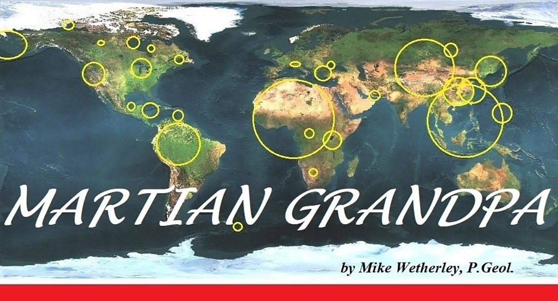
Carl Sagan wrote: “Astronomers do not object to the idea of major collisions, only to major recent collisions.” Why? The reason, obviously, is that they…he…didn’t know how to recognize evidence of major recent collisions. The Caribbean offers an opportunity for scientists to study the site of a major recent collision so they can learn what it looks like. The area is highly accessible, with a generally pleasant climate and readily available accommodation, so that professors and their students are unlikely to object to working there.
An examination of this region will provide scientists the chance to advance out of the current Scientific Dark Age on the right-hand side of The Chocolate Box to recognize how catastrophism has shaped our world. It might enable investigators to determine a more precise age for the impact, put aside the absurd role they have assigned Chicxulub, and determine characteristics that can be applied to interpret similar sites around the world.
It doesn’t take much scholarship to recognize the cause of the Barringer Crater, near Flagstaff, Arizona because there is a big hole in the ground. There is clearly a need, however, for scientists to learn how to recognize sites sufficiently large to have formed a convection cell. When scientists realize that large asteroid impacts provide the energy required by plate tectonics, moving continents around as a result, the history of our physical world will become much more understandable to them.
I even dare to hope that astronomers will begin to consider how large asteroids from the Main Asteroid Belt get to Earth since their frequency of impact cannot be explained by chance alone. Of course, for astronomers to accept that planets and (world-type) moons are not fixed in their orbits but sometimes leave them to interact with others, could take a couple more centuries.
The objective is nothing less than a new way of doing science on the right-hand side of the Chocolate Box. We mustn’t dismiss reports just because they are a couple of thousand years old, or because one source happens to be a religious book. (Velikovsky wrote in ‘Worlds in Collision’: “….least of all do we place faith in books that demand belief, religious books, though we swear on these.”)
Greater integration of the sciences is a critical requirement, and ‘generalist’ must not be considered a derogatory term. And let me be clear on this point: Co-operation between specialists is not going to get us very far on the right-hand side of the Chocolate Box. It never has. This does not mean that every geologist or astronomer has to develop a command of every subject, but scientists must develop broader interests than they have now, including knowledge of human history over the past 4,000 years.
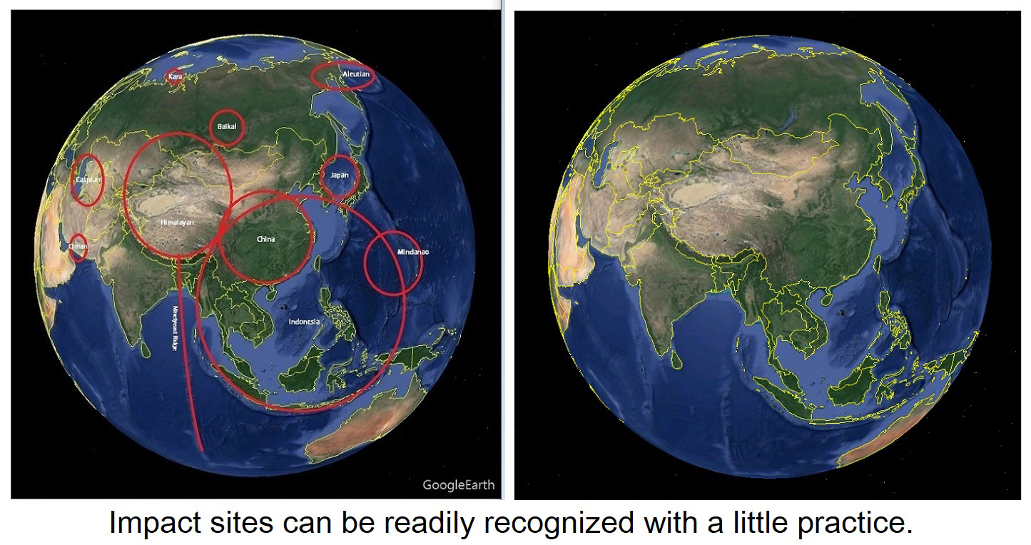 Major new concepts in geology and astronomy are not too difficult for the general public to appreciate. For example, major impact sites are ‘hiding in plain sight’ all over our planet. The joint NASA-ESA Ulysses program demonstrated that it is electricity that powers our Sun, and by extension, the stars. Particle Physics, which seems to exist increasingly to support the Big Bang hypothesis, is an inward-looking science and should not continue for long in its present form.
We can do better, and an investigation of the geology of the Caribbean Sea would be a good place to start. Once the first sacred cows have been put out to pasture things will get easier.
 Most Recent Impact
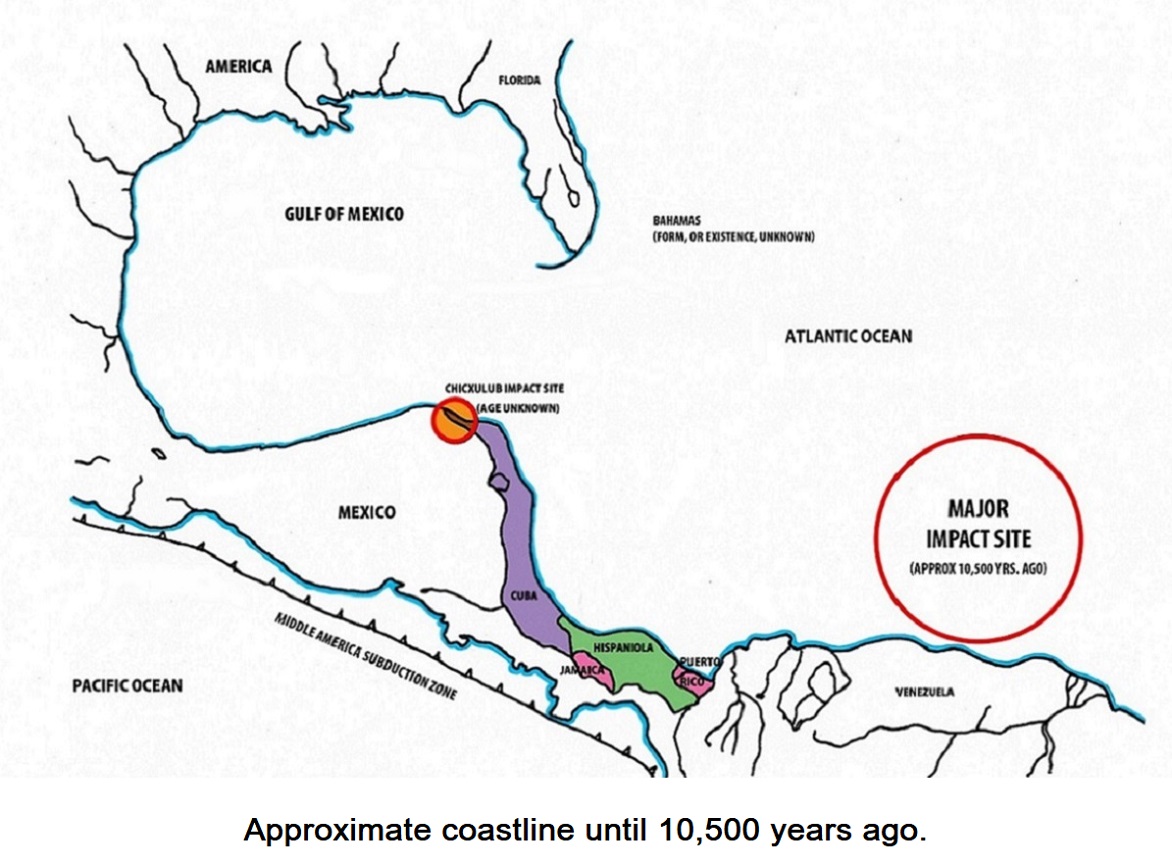
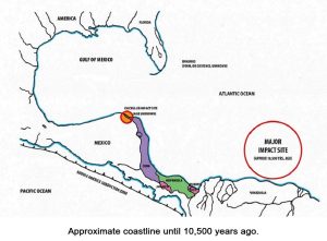
A major impact formed the Venezuela Basin about 10,500 years ago, and points at the geographic poles were moved about 220 closer to the present equator. In the northern and southern hemispheres, the former and present geographic poles are situated about 100 of longitude apart (in the present coordinate system.) This means that it took about 40 minutes for the poles to move about 1650 miles from their former positions. Therefore, the axis change took place at a speed of close to 2,475 miles per hour, which is more than 3 times the speed of sound in air at sea level. A 700 km (435 mi.) diameter convection cell formed at the impact site and a pair of parallel faults developed from it, trending toward the Middle America Subduction Zone.
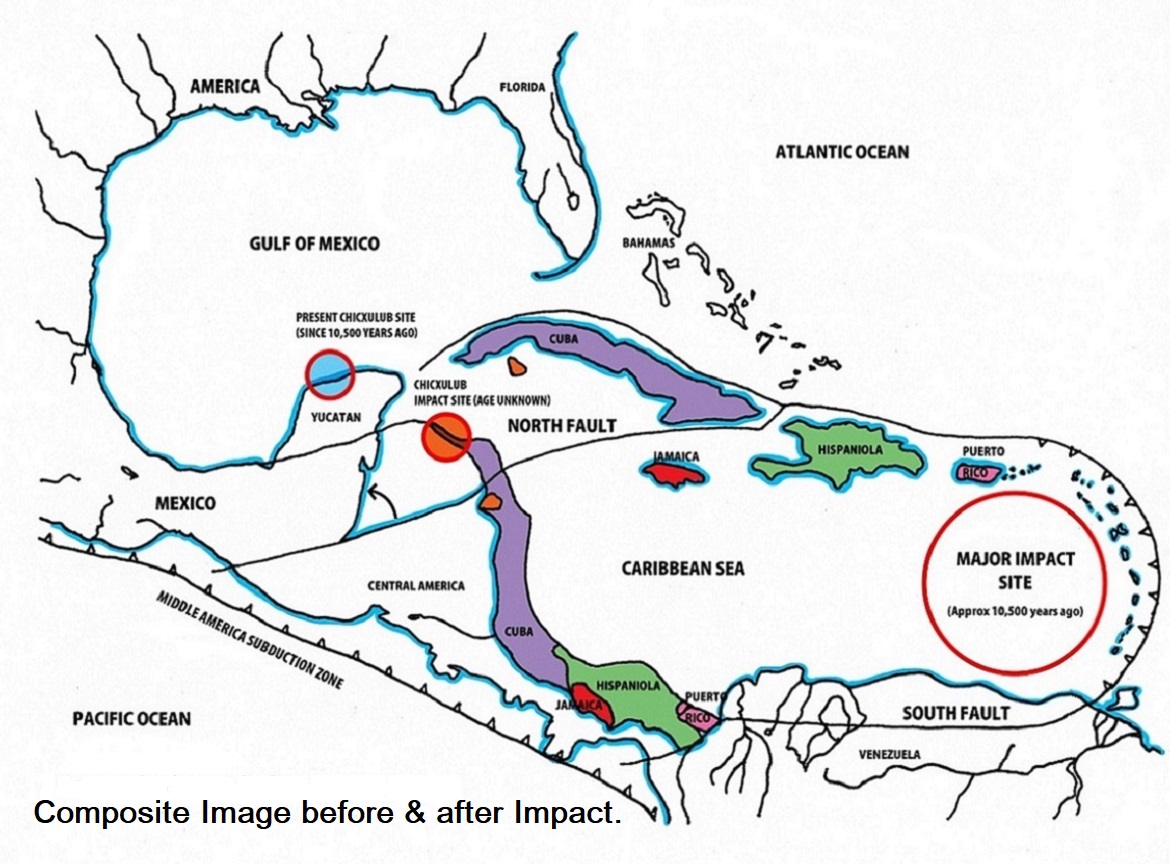 A surge of magma from the convection cell, confined between the two faults, was deflected upward by the plunging plate, tearing what are now the Greater Antilles (Cuba, Hispaniola, Jamaica and Puerto Rico), plus some smaller pieces, out of Central America and moving them up to 1500 km (more than 900 miles) away. The paths they took can be easily recognized on a physical map of the Caribbean Sea, just as with islands of the Mediterranean Sea. It’s not as if they were hiding their tracks. And where the crust was torn open at the Gulf of Honduras, accommodating the northward rotation of the Yucatán, the evidence can be clearly recognized on GoogleEarth.
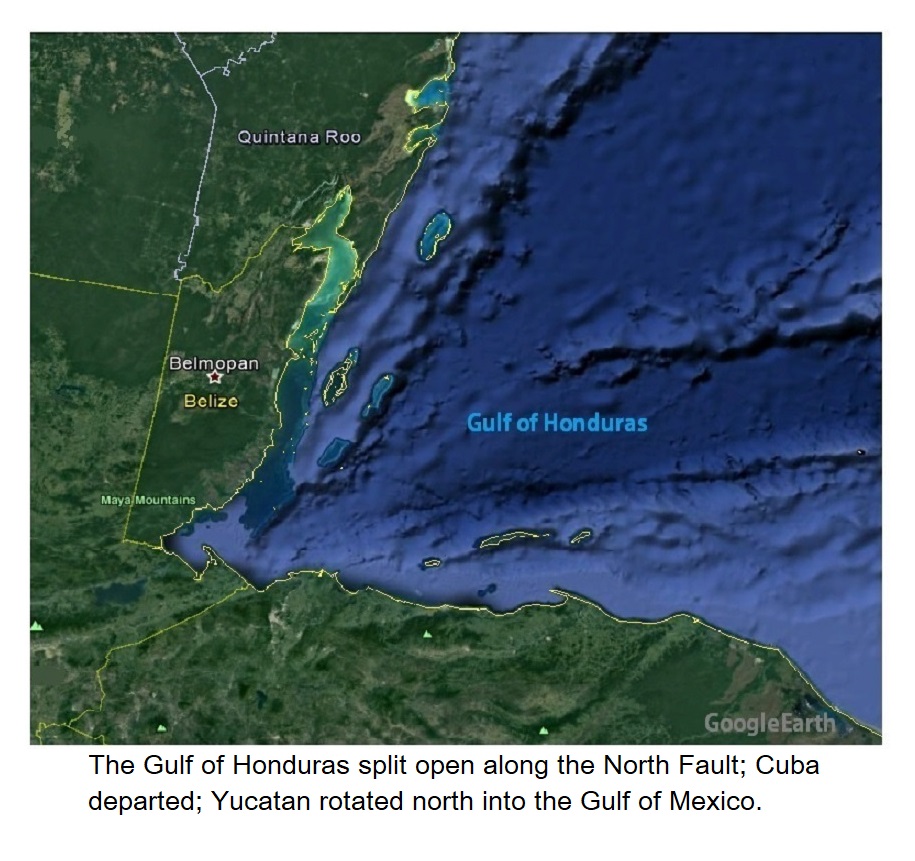 As Cuba separated from the mainland the Yucatán Peninsula rotated north taking with it the infamous Chicxulub impact site, or at least its upper part, so that its roots might still be detectable where the impact actually occurred. The island arc formed by the Leeward and Windward islands is made up of young, frequently active volcanic islands that developed as a result of the impact. Oceanic crust from the Mid Atlantic Ridge is now being subducted along the east limb of the convection cell, resulting in the growth of these volcanic islands. At its north end, the arc has begun to divide in two, influenced by the westward moving plate to the north.
Trinidad, as well as Barbados (which is mostly limestone), were broken out of South America. The ‘Aves Swell’ , now deep beneath the surface of the sea, may once have been a peninsula of South America (an extension of the Guiana Shield), and is the probable source of the ‘Gorda Baths’ on the British Virgin Islands, where massive rounded boulders of granodiorite up to 12 meters (40 ft.) in diameter are piled up at the edge of the sea. The islands between Trinidad and the British Virgin Islands are made of volcanic rock (which granodiorite is not) having an age of less than about 10,500 years.
As the Greater Antilles moved to their present locations the surface of the mantle was left exposed. Sediments were deposited by the furious tides following the axis change. These are the same sediments the university professors declared were 90 million years old, based upon fossils they allegedly contain. Ten thousand five hundred years after the sediments were laid down they would be mapped by USGS geologists, who had already decided they were Tertiary, meaning an age of between 1.5 and 66 million years. Something doesn’t add up!
Proofs
- Cores of volcanic rock from beneath the sediments should be dated by the 40Ar-39Ar method. This time, the results should be released to the public.
- The original location of the Chicxulub impact might be identifiable by geophysical means.
- Standard geological mapping techniques might satisfy skeptics of how the Greater Antilles were part of Central America until about 10,500 years ago.
- While they’re at it, a competent paleontologist might want to take a look at those 90 million-year-old fossils.
Arthur Schopenhauer
In concluding this series, I want to remind you of what this 19th-century German philosopher wrote about truth:
“All truth passes through three stages.
First, it is ridiculed.
Second, it is violently opposed.
Third, it is accepted as being self-evident.”
Thank you,

Mike Wetherley, P.Geol.